
Make a donation
Gear up for your next adventure:
As an Amazon Associate, this site earns from qualifying purchases at no extra cost to you.
Oven Creek topographic map
Click on the map to display elevation.
Make a donation
Gear up for your next adventure:
As an Amazon Associate, this site earns from qualifying purchases at no extra cost to you.
About this map
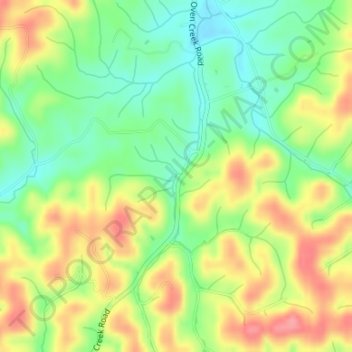
Name: Oven Creek topographic map, elevation, terrain.
Location: Oven Creek, Cocke County, Tennessee, 37868, United States (36.03654 -83.08230 36.03697 -83.08201)
Average elevation: 1,286 ft
Minimum elevation: 1,152 ft
Maximum elevation: 1,444 ft
Tennessee trails, hiking, mountain biking, running and outdoor activities
Make a donation
Gear up for your next adventure:
As an Amazon Associate, this site earns from qualifying purchases at no extra cost to you.
Other topographic maps
Click on a map to view its topography, its elevation and its terrain.
Make a donation
Gear up for your next adventure:
As an Amazon Associate, this site earns from qualifying purchases at no extra cost to you.
Old Hickory Lake
United States > Tennessee > Wilson County > Mount Juliet
Old Hickory Lake is a mainstream storage impoundment on the Cumberland River operated by the U.S. Army Corps of Engineers. The reservoir contains 22,500 acres (91 km2) at an elevation of 445 feet (above sea level) and extends 97.3 river miles. Water level fluctuations are minimal with minimum pool elevation at…
Average elevation: 561 ft
Make a donation
Gear up for your next adventure:
As an Amazon Associate, this site earns from qualifying purchases at no extra cost to you.
Radnor Lake State Natural Area
United States > Tennessee > Davidson County > Nashville-Davidson
Average elevation: 869 ft
Make a donation
Gear up for your next adventure:
As an Amazon Associate, this site earns from qualifying purchases at no extra cost to you.
Make a donation
Gear up for your next adventure:
As an Amazon Associate, this site earns from qualifying purchases at no extra cost to you.
West Tennessee
West Tennessee is located almost entirely within the Mississippi Embayment, part of the Gulf Coastal Plain. Because of this, the terrain is flatter than the eastern parts of the state. Areas along the Mississippi River are located within the Mississippi Alluvial Plain, which is primarily a floodplain with many…
Average elevation: 417 ft
Staffordtown
United States > Tennessee > Polk County > Copperhill
Staffordtown is situated in the scenic Appalachian region, characterized by its rugged terrain and lush forests. The area is marked by steep hills and rolling valleys that define the landscape, with elevations ranging from around 1,500 to 3,000 feet above sea level. The surrounding mountains, part of the…
Average elevation: 1,568 ft
Make a donation
Gear up for your next adventure:
As an Amazon Associate, this site earns from qualifying purchases at no extra cost to you.
Make a donation
Gear up for your next adventure:
As an Amazon Associate, this site earns from qualifying purchases at no extra cost to you.
South Pittsburg
United States > Tennessee > Marion County
South Pittsburg is located at 35°0′30″N 85°42′38″W / 35.00833°N 85.71056°W / 35.00833; -85.71056 (35.008342, -85.710645). The city is situated in the southwestern Sequatchie Valley between the Cumberland Plateau on the west and the Tennessee River (Guntersville Lake) on the east. Two steep…
Average elevation: 892 ft
Fall Creek Falls State Park
United States > Tennessee > Van Buren County
Just beyond its source, Cane Creek slowly gains strength as it absorbs Meadow Creek and several smaller streams. As the creek enters the gorge, it drops several hundred feet in less than a mile, including 45 feet (14 m) over Cane Creek Cascades and 85 feet (26 m) over Cane Creek Falls. A few hundred meters…
Average elevation: 1,719 ft
Make a donation
Gear up for your next adventure:
As an Amazon Associate, this site earns from qualifying purchases at no extra cost to you.
Make a donation
Gear up for your next adventure:
As an Amazon Associate, this site earns from qualifying purchases at no extra cost to you.
Henderson Springs
United States > Tennessee > Sevier County > Pigeon Forge
Average elevation: 1,079 ft
Make a donation
Gear up for your next adventure:
As an Amazon Associate, this site earns from qualifying purchases at no extra cost to you.
Make a donation
Gear up for your next adventure:
As an Amazon Associate, this site earns from qualifying purchases at no extra cost to you.
Make a donation
Gear up for your next adventure:
As an Amazon Associate, this site earns from qualifying purchases at no extra cost to you.
Make a donation
Gear up for your next adventure:
As an Amazon Associate, this site earns from qualifying purchases at no extra cost to you.
Make a donation
Gear up for your next adventure:
As an Amazon Associate, this site earns from qualifying purchases at no extra cost to you.
Make a donation
Gear up for your next adventure:
As an Amazon Associate, this site earns from qualifying purchases at no extra cost to you.
Make a donation
Gear up for your next adventure:
As an Amazon Associate, this site earns from qualifying purchases at no extra cost to you.
Make a donation
Gear up for your next adventure:
As an Amazon Associate, this site earns from qualifying purchases at no extra cost to you.
Make a donation
Gear up for your next adventure:
As an Amazon Associate, this site earns from qualifying purchases at no extra cost to you.
Make a donation
Gear up for your next adventure:
As an Amazon Associate, this site earns from qualifying purchases at no extra cost to you.
Make a donation
Gear up for your next adventure:
As an Amazon Associate, this site earns from qualifying purchases at no extra cost to you.
Hopewell
United States > Tennessee > Bradley County
According to the United States Census Bureau, the CDP has a total area of 7.1 square miles (18 km2), all land. It sits at an elevation of approximately 722 feet (220 m) above sea level, one of the lowest elevations in Bradley County.
Average elevation: 833 ft
Make a donation
Gear up for your next adventure:
As an Amazon Associate, this site earns from qualifying purchases at no extra cost to you.
Make a donation
Gear up for your next adventure:
As an Amazon Associate, this site earns from qualifying purchases at no extra cost to you.
Make a donation
Gear up for your next adventure:
As an Amazon Associate, this site earns from qualifying purchases at no extra cost to you.
Make a donation
Gear up for your next adventure:
As an Amazon Associate, this site earns from qualifying purchases at no extra cost to you.
Make a donation
Gear up for your next adventure:
As an Amazon Associate, this site earns from qualifying purchases at no extra cost to you.
Make a donation
Gear up for your next adventure:
As an Amazon Associate, this site earns from qualifying purchases at no extra cost to you.