Geolocate

Martins Ferry topographic map

Interactive map

Click on the map to display elevation.

About this map

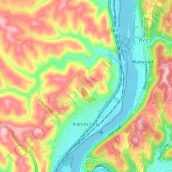
Name: Martins Ferry topographic map, elevation, terrain.

Location: Martins Ferry, Belmont County, Ohio, United States (40.07977 -80.74806 40.13742 -80.70645)

Average elevation: 945 ft

Minimum elevation: 627 ft

Maximum elevation: 1,306 ft

Belmont County trails, hiking, mountain biking, running and outdoor activities

Other topographic maps

Click on a map to view its topography, its elevation and its terrain.

Crescent

United States > Ohio > Belmont County

Average elevation: 1,030 ft

Centerville

United States > Ohio > Belmont County

Average elevation: 1,188 ft

Warnock

United States > Ohio > Belmont County

Average elevation: 1,106 ft

Barton

United States > Ohio > Belmont County

Average elevation: 1,033 ft

Lafferty

United States > Ohio > Belmont County

Average elevation: 1,129 ft

Bannock

United States > Ohio > Belmont County

Average elevation: 1,112 ft

Glencoe

United States > Ohio > Belmont County

Average elevation: 1,040 ft

Boston

United States > Ohio > Belmont County

Average elevation: 1,201 ft

Alledonia

United States > Ohio > Belmont County

Average elevation: 1,050 ft

Lansing

United States > Ohio > Belmont County

Average elevation: 974 ft

Blaine

United States > Ohio > Belmont County

Average elevation: 1,017 ft

Captina

United States > Ohio > Belmont County

Average elevation: 948 ft

Lloydsville

United States > Ohio > Belmont County

Average elevation: 1,181 ft

Badgertown

United States > Ohio > Belmont County

Average elevation: 1,201 ft

Jacobsburg

United States > Ohio > Belmont County

Average elevation: 1,168 ft

Wolfhurst

United States > Ohio > Belmont County

Average elevation: 971 ft

Piedmont Lake

United States > Ohio > Belmont County

Average elevation: 1,053 ft