
New York topographic map
Click on the map to display elevation.
New York
New York City's topography is a fascinating blend of varied elevations and unique landscapes, reflecting its diverse geography across five boroughs. Situated at the confluence of the Hudson and East Rivers, the city primarily features low-lying terrain, with the average elevation hovering around sea level. However, notable hills punctuate the urban landscape, especially in the Bronx, which has rolling hills in areas like Riverdale, and Staten Island, where Todt Hill rises to approximately 410 feet (125 meters), making it the highest point in the city. Manhattan showcases its highest natural point at Bennett Park, reaching about 265 feet (81 meters), while areas like Central Park offer elevated spots, providing scenic views amidst the urban setting. Queens presents a mix of coastal lowlands and higher elevations, particularly in neighborhoods like Forest Hills, while Brooklyn's varied terrain ranges from flatlands at Coney Island to elevated areas such as Park Slope. Overall, the city's topography significantly influences its infrastructure, recreational spaces, and urban planning.
About this map
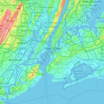
Name: New York topographic map, elevation, terrain.
Location: New York, United States (40.47658 -74.25884 40.91763 -73.70023)
Average elevation: 62 ft
Minimum elevation: -20 ft
Maximum elevation: 679 ft
New York trails, hiking, mountain biking, running and outdoor activities
Other topographic maps
Click on a map to view its topography, its elevation and its terrain.
Central Park
United States > New York > New York County > New York
In June 1856, Fernando Wood appointed a "consulting board" of seven people, headed by author Washington Irving, to inspire public confidence in the proposed development. Wood hired military engineer Egbert Ludovicus Viele as the park's chief engineer, tasking him with a topographical survey of the site. The…
Average elevation: 85 ft
Tug Hill
United States > New York > Oswego County
The core Tug Hill region encompasses 150,000 acres (610 km2) of unbroken, generally second-growth, northern hardwood forest, and is drained by a vast network of streams. Important rivers and streams whose headwaters are located within the Tug Hill region include the Mohawk River, Deer River, Salmon River, Mad…
Average elevation: 358 ft
Mount Marcy
United States > New York > Essex County > Town of Keene
Mount Marcy is the highest point in the Adirondack Mountains and the U.S. state of New York, with an elevation of 5,343.1 feet (1,628.6 m). It is located in the town of Keene in Essex County. The mountain is in the heart of the High Peaks Wilderness Area in Adirondack Park. Like the surrounding Adirondack…
Average elevation: 4,229 ft
Inwood Hill Park
United States > New York > New York County > New York
Inwood Hill Park is a 196 acres (79 ha) public park in the Inwood neighborhood of Manhattan, New York City, operated by the New York City Department of Parks and Recreation. On a high schist ridge that rises 200 feet (61 m) above the Hudson River from Dyckman Street to the northern tip of the island, Inwood…
Average elevation: 46 ft
Brooklyn Bridge Park
United States > New York > Kings County > New York
Brooklyn Bridge Park spans 85 acres (34 ha) of the East River waterfront in the Brooklyn Heights and Dumbo neighborhoods of Brooklyn. The park is divided into eleven sections: Piers 1 through 6; Fulton Ferry Landing; Brooklyn Bridge Plaza; Empire Fulton Ferry; Main Street; and John Street. Each of these…
Average elevation: 30 ft
Rosedale
United States > New York > Westchester County > City of White Plains
Average elevation: 187 ft
Smithtown Pines
United States > New York > Suffolk County > Town of Smithtown
Average elevation: 95 ft
Whitesville
United States > New York > Allegany County > Town of Independence
Average elevation: 2,005 ft
Potter Hollow
United States > New York > Albany County > Town of Rensselaerville
Average elevation: 1,135 ft
Hartmans Corners
United States > New York > Albany County > Town of Guilderland
Average elevation: 266 ft
Pleasantside
United States > New York > Westchester County > Town of Cortlandt
Average elevation: 354 ft
Brick House Corners
United States > New York > Genesee County > Town of Pembroke
Average elevation: 860 ft
Mariandale
United States > New York > Westchester County > Village of Ossining
Average elevation: 174 ft
Balsam Mountain
United States > New York > Ulster County > Town of Shandaken
Average elevation: 2,746 ft
Catamount Mountain
United States > New York > Saint Lawrence County > Town of Colton
Average elevation: 1,421 ft
Oscawana Corners
United States > New York > Putnam County > Town of Putnam Valley
Average elevation: 518 ft
Lake Vanare
United States > New York > Warren County > Town of Lake Luzerne
Average elevation: 1,014 ft
Woodcock Mountain
United States > New York > Saratoga County > Town of Hadley
Average elevation: 889 ft
Constantia Center
United States > New York > Oswego County > Town of Constantia
Average elevation: 554 ft
South New Berlin
United States > New York > Chenango County > Town of New Berlin
Average elevation: 1,247 ft
Coney Island
United States > New York > Saint Lawrence County > Town of Pierrepont
Average elevation: 571 ft
Holiday Valley
United States > New York > Cattaraugus County > Ellicottville
Average elevation: 1,788 ft
South Setauket
United States > New York > Suffolk County > Town of Brookhaven
Average elevation: 144 ft
Henry Johnson Park
United States > New York > Albany County > City of Albany
Average elevation: 167 ft
Sunset Ridge
United States > New York > Westchester County > Town/Village of Harrison
Average elevation: 89 ft
Broome Center
United States > New York > Schoharie County > Town of Gilboa
Average elevation: 2,051 ft
Ellicottville
United States > New York > Cattaraugus County > Village of Ellicottville
Average elevation: 1,880 ft
Reynolds
United States > New York > Rensselaer County > Town of Schaghticoke
Average elevation: 144 ft