
Jeju topographic map
Interactive map
Click on the map to display elevation.
Jeju
The island is home to 660,000 people, but hosts 15,000,000 visitors per year. English is not widely spoken in Jeju, and as a matter of fact, "the local dialect is different enough from Korean that it is recognized as a distinct language." "Until recently, Chinese travelers accounted for 80% of foreign travelers"; however, due to the installation of THAAD (The Terminal High Altitude Area Defense) system in Korea, Chinese travel has dwindled drastically. "THAAD is supposed to shield against North Korean missiles" however China views it as a security threat. Though in the past year [2017] tourism has declined sharply, visits to Jeju continue to be a vacation destination for Asia. There are no visa requirements for visitors staying up to 90 days and future plans to build a second international airport have been discussed. Due to the decline of visitors caused by China's travel ban to Korea due to the concern of THAAD, talks and discussions continue to be held regarding a second airport to service over 45 million people with an anticipated completion by 2035. The current Jeju International Airport is crowded, as it services "30 million, which is 4 million more than it was designed to handle." The current desire of the existing Jeju International Airport includes wanting to add more direct flights, nonstop to major cities including Tokyo, Osaka, Beijing, Shanghai, and Taipei.
About this map
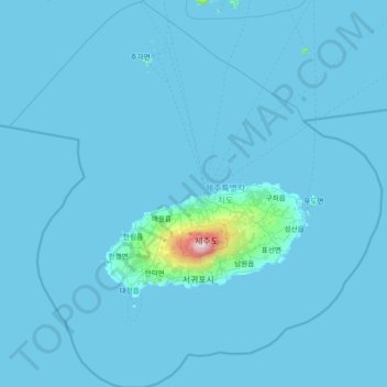
Name: Jeju topographic map, elevation, terrain.
Location: Jeju, South Korea (32.91046 125.79410 34.13981 127.21523)
Average elevation: 92 ft
Minimum elevation: -3 ft
Maximum elevation: 6,122 ft
Other topographic maps
Click on a map to view its topography, its elevation and its terrain.
Turczaninow Hornbeam Tree at Chamseongdan Altar
South Korea > Ganghwa-gun > Incheon > Hwado-myeon
Average elevation: 509 ft
Hallasan
The occurrence of the highest temperature coincides with the formation position of Eddy, and when the wind is weak, it is formed in the middle mountain region. When the wind is weak, the warmth is accumulated in the middle layer, so the maximum temperature in the mid-mountainous area is higher than the maximum…
Average elevation: 5,420 ft
Changdeokgung Palace
South Korea > Jongno 1·2·3·4(ilisamsa)-ga-dong
Changdeokgung was the most favored palace of many Joseon princes and retained many elements dating from the Three Kingdoms of Korea period that were not incorporated in the more contemporary Gyeongbokgung. One such element is the fact that the buildings of Changdeokgung blend with the natural topography of the…
Average elevation: 213 ft