
Make a donation
Gear up for your next adventure:
As an Amazon Associate, this site earns from qualifying purchases at no extra cost to you.
Budhanilkantha topographic map
Click on the map to display elevation.
Make a donation
Gear up for your next adventure:
As an Amazon Associate, this site earns from qualifying purchases at no extra cost to you.
About this map
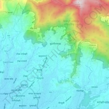
Name: Budhanilkantha topographic map, elevation, terrain.
Location: Budhanilkantha, Kathmandu, Bagmati Pradesh, Nepal (27.72655 85.33761 27.81413 85.38926)
Average elevation: 5,262 ft
Minimum elevation: 4,268 ft
Maximum elevation: 8,862 ft
Make a donation
Gear up for your next adventure:
As an Amazon Associate, this site earns from qualifying purchases at no extra cost to you.
Other topographic maps
Click on a map to view its topography, its elevation and its terrain.
Himalayas
Nepal > Koshi Province > Solukhumbu
The Himalayas present a dramatic and varied topography characterized by towering peaks, deep valleys, and extensive glaciers. This majestic mountain range features some of the highest elevations on Earth, including Mount Everest, which rises to 29,035 feet. The terrain is marked by steep, jagged ridges and…
Average elevation: 24,787 ft
Kathmandu
Nepal > Bagmati Province > Kathmandu
Kathmandu is located at an elevation of approximately 4,600 feet (1,400 meters) within the Kathmandu Valley. This valley is characterized by a bowl-like topography, encircled by the lower Himalayan ranges, which rise sharply in the north, culminating in peaks that exceed 24,000 feet (7,300 meters). The…
Average elevation: 5,046 ft
Mount Everest
Nepal > Eastern Development Region > Khumjung
Mount Everest (Chinese: 珠穆朗玛 Zhūmùlǎngmǎ; Nepali: सगरमाथा Sagarmāthā; Tibetan: Chomolungma ཇོ་མོ་གླང་མ) is Earth's highest mountain above sea level, located in the Mahalangur Himal sub-range of the Himalayas. The China–Nepal border runs across its summit…
Average elevation: 25,725 ft
Himalayas
Nepal > Koshi Province > Solukhumbu
The Himalayas, or Himalaya (/ˌhɪməˈleɪ.ə, hɪˈmɑːləjə/; Sanskrit: [ɦɪmaːlɐjɐ]; from Sanskrit himá 'snow, frost', and ā-laya 'dwelling, abode'), is a mountain range in Asia, separating the plains of the Indian subcontinent from the Tibetan Plateau. The range has some of the planet's highest…
Average elevation: 24,787 ft
Make a donation
Gear up for your next adventure:
As an Amazon Associate, this site earns from qualifying purchases at no extra cost to you.
Mount Everest
Nepal > Koshi Province > Solukhumbu
Mount Everest (Nepali: सगरमाथा, romanized: Sagarmāthā; Standard Tibetan: ཇོ་མོ་གླང་མ, romanized: Chomolungma; Chinese: 珠穆朗玛峰; pinyin: Zhūmùlǎngmǎ Fēng) is Earth's highest mountain above sea level, located in the Mahalangur Himal sub-range of the Himalayas.…
Average elevation: 25,745 ft
Make a donation
Gear up for your next adventure:
As an Amazon Associate, this site earns from qualifying purchases at no extra cost to you.
Make a donation
Gear up for your next adventure:
As an Amazon Associate, this site earns from qualifying purchases at no extra cost to you.
Mount Everest
Nepal > Koshi Province > Solukhumbu
Mount Everest is Earth's highest mountain above sea level, located in the Mahalangur Himal sub-range of the Himalayas. The China–Nepal border runs across its summit point. Its elevation (snow height) of 8,848.86 m (29,031 ft 8+1⁄2 in) was most recently established in 2020 by the Chinese and Nepali authorities.
Average elevation: 25,745 ft
Make a donation
Gear up for your next adventure:
As an Amazon Associate, this site earns from qualifying purchases at no extra cost to you.
Mount Everest
Nepal > Koshi Province > Solukhumbu
Mount Everest (Nepali: सगरमाथा, romanized: Sagarmāthā; Tibetan: Chomolungma ཇོ་མོ་གླང་མ; Chinese: 珠穆朗玛峰; pinyin: Zhūmùlǎngmǎ Fēng) is Earth's highest mountain above sea level, located in the Mahalangur Himal sub-range of the Himalayas. The China–Nepal…
Average elevation: 25,755 ft
Arun River
Nepal > Koshi Province > Sankhuwasabha > Num
The Tibetan name Bum-chu may refer to a religious ceremony attempting to divine prospects for the coming year from the level of water in a pot or well, chu is the Tibetan word for water. The river originates near Gutso in Nyalam County of Tibet. Around 17 kilometres (11 mi) downstream, the Men-chu joins it.…
Average elevation: 3,783 ft
Make a donation
Gear up for your next adventure:
As an Amazon Associate, this site earns from qualifying purchases at no extra cost to you.
Mera Peak
Nepal > Koshi Province > Solukhumbu
In September 2017, Hari Budha Magar summited Mera Peak, becoming the first double above-knee amputee to climb a mountain over 6,000m in altitude.
Average elevation: 18,730 ft
Make a donation
Gear up for your next adventure:
As an Amazon Associate, this site earns from qualifying purchases at no extra cost to you.
Ghorahi
Nepal > Lumbini Province > Dang
Ghorahi is the main town of the Rapti Zone and also the headquarters of the Dang district. It is located at an elevation of 2,300 feet (700 m) in the Mahabharat-Chure hill region.
Average elevation: 2,838 ft
Make a donation
Gear up for your next adventure:
As an Amazon Associate, this site earns from qualifying purchases at no extra cost to you.
Mount Everest
Nepal > Koshi Province > Solukhumbu
Mount Everest (Nepali: सगरमाथा, romanized: Sagarmāthā; Standard Tibetan: ཇོ་མོ་གླང་མ, romanized: Chomolungma; Chinese: 珠穆朗玛峰; pinyin: Zhūmùlǎngmǎ Fēng) is Earth's highest mountain above sea level, located in the Mahalangur Himal sub-range of the Himalayas.…
Average elevation: 25,745 ft
Sarangkot
Nepal > Gandaki Province > Kaski > Pokhara
The Ward is located on Sarangkot, a hill on the western side of Pokhara with an altitude of 1600m. Sarangkot is known for its panoramic Himalayan views of Dhaulagiri, Annapurna and Manaslu. It also provides an expansive view of the city of Pokhara, from the extreme north to the south including Phewa Lake.…
Average elevation: 3,737 ft
Gorak Shep
Nepal > Koshi Province > Solukhumbu
Gorak Shep or Gorakshep (Nepali: गोरकशेप) is a small settlement that sits on the edge of a frozen lakebed covered with sand in Nepal with the same name. It is found at an elevation of 5,164 metres (16,942 ft) elevation, near Mount Everest. The village is not inhabited year-round.
Average elevation: 17,241 ft
Make a donation
Gear up for your next adventure:
As an Amazon Associate, this site earns from qualifying purchases at no extra cost to you.
Mount Everest
Nepal > Koshi Province > Solukhumbu
Mount Everest (Nepali: सगरमाथा, romanized: Sagarmāthā; Standard Tibetan: ཇོ་མོ་གླང་མ, romanized: Chomolungma; Chinese: 珠穆朗玛峰; pinyin: Zhūmùlǎngmǎ Fēng) is Earth's highest mountain above sea level, located in the Mahalangur Himal sub-range of the Himalayas.…
Average elevation: 25,745 ft
Make a donation
Gear up for your next adventure:
As an Amazon Associate, this site earns from qualifying purchases at no extra cost to you.
Nagarkot
Nepal > Bagamati Province > Kavrepalanchok
Nagarkot (Nepali: नगरकोट) is a former village development committee located 32 km east of Kathmandu, Nepal, in Bhaktapur District in Bagmati Province and as of 2015 part of Nagarkot Municipality. At the time of the 2011 census it had a population of 4,571 and had 973 houses in it. At an elevation…
Average elevation: 5,509 ft
Pokhara
Pokhara is in the northwestern corner of the Pokhara Valley, which is a widening of the Seti Gandaki valley that lies in the region (Pahad) of the Himalayas. In this region the mountains rise very quickly, and within 30 kilometres (19 miles), the elevation rises from 1,000 to 7,500 metres (3,300 to 24,600…
Average elevation: 4,009 ft
Make a donation
Gear up for your next adventure:
As an Amazon Associate, this site earns from qualifying purchases at no extra cost to you.
Manaslu
Nepal > Gandaki Province > Gorkha
The Manaslu region offers a variety of trekking options. The popular Manaslu trekking route of 177 kilometres (110 mi) skirts the Manaslu massif over the pass down to Annapurna. The Nepalese Government only permitted trekking on this circuit in 1991. The trekking trail follows an ancient salt-trading route…
Average elevation: 23,192 ft
Lalitpur
Nepal > Bagamati Province > Lalitpur
Lalitpur Metropolitan City (Sanskrit: पाटन Pāṭana, Nepal bhasa : 𑐫𑐮 Yala) is a metropolitan city and fourth most populous city of Nepal with 299,843 inhabitants living in 49,044 households per the 2021 census. It is located in the south-central part of Kathmandu Valley, a large valley in…
Average elevation: 5,276 ft
Make a donation
Gear up for your next adventure:
As an Amazon Associate, this site earns from qualifying purchases at no extra cost to you.
Nagarkot
Nepal > Bagmati Province > Kavrepalanchok
Nagarkot (Nepali: नगरकोट) is a former Village Development Committee located 32 km east of Kathmandu, Nepal in Bhaktapur District in Bagmati Province and as of 2015 part of Nagarkot Municipality. At the time of the 2011 census it had a population of 4,571 and had 973 houses in it. At an elevation of…
Average elevation: 5,509 ft
Mount Everest
Nepal > Koshi Province > Solukhumbu
Mount Everest (Nepali: सगरमाथा, romanized: Sagarmāthā; Standard Tibetan: ཇོ་མོ་གླང་མ, romanized: Chomolungma; Chinese: 珠穆朗玛峰; pinyin: Zhūmùlǎngmǎ Fēng) is Earth's highest mountain above sea level, located in the Mahalangur Himal sub-range of the Himalayas.…
Average elevation: 25,745 ft
Make a donation
Gear up for your next adventure:
As an Amazon Associate, this site earns from qualifying purchases at no extra cost to you.
Tengboche
Nepal > Koshi Province > Solukhumbu
Tengboche is located on a hill at the confluence of the Dudh Kosi and the Imja Khola rivers. It lies in Solukhumbu district to the north east of Kathmandu on the Nepal – Tibet border. It is inhabited by sherpas ('sherpa' literally means the easterner) who migrated from Tibet six hundred years ago. It is…
Average elevation: 12,913 ft
Hadeban Upabhokta Samiti , Lamachaur -19
Nepal > Gandaki Province > Kaski > Pokhara
Average elevation: 3,419 ft
Make a donation
Gear up for your next adventure:
As an Amazon Associate, this site earns from qualifying purchases at no extra cost to you.
Himalayas
Nepal > Koshi Province > Solukhumbu
The Himalayas, or Himalaya (/ˌhɪməˈleɪ.ə, hɪˈmɑːləjə/ HIM-ə-LAY-ə, hih-MAH-lə-yə) is a mountain range in Asia, separating the plains of the Indian subcontinent from the Tibetan Plateau. The range has some of the Earth's highest peaks, including the highest, Mount Everest. More than 100 peaks…
Average elevation: 24,787 ft
Nuptse I
Nepal > Koshi Province > Solukhumbu
Nuptse or Nubtse (Sherpa: ནུབ་རྩེ། नुबचे, Wylie: Nub rtse, Chinese: 努子峰) is a mountain in the Khumbu region of the Mahalangur Himal, in the Nepalese Himalayas. It lies 2 km (1.2 mi) WSW of Mount Everest. The main peak, Nuptse I at an elevation of 7,861 m (25,791 ft), was first…
Average elevation: 22,418 ft
Make a donation
Gear up for your next adventure:
As an Amazon Associate, this site earns from qualifying purchases at no extra cost to you.
Make a donation
Gear up for your next adventure:
As an Amazon Associate, this site earns from qualifying purchases at no extra cost to you.
Annapurna I
Nepal > Gandaki Province > Myagdi
The mountain is named after Annapurna, the Hindu goddess of food and nourishment, who is said to reside there. The name Annapurna is derived from the Sanskrit-language words purna ("filled") and anna ("food"), and can be translated as "everlasting food". Many streams descending from the slopes of the Annapurna…
Average elevation: 23,379 ft
Make a donation
Gear up for your next adventure:
As an Amazon Associate, this site earns from qualifying purchases at no extra cost to you.
Make a donation
Gear up for your next adventure:
As an Amazon Associate, this site earns from qualifying purchases at no extra cost to you.
Lalitpur
Nepal > Bagamati Province > Lalitpur
Lalitpur (Nepali: ललितपुर) is a metropolitan city and fourth most populous city of Nepal with 299,843 inhabitants living in 77,159 households per the 2021 census. It is located in the south-central part of Kathmandu Valley, a large valley in the high plateaus in central Nepal, at an altitude of…
Average elevation: 5,276 ft
Manang
Nepal > Gandaki Province > Manang
Manang (Nepali: मनाङ) is a town in the Manang District of Nepal. It is located at 28°40'0N 84°1'0E with an elevation of 3,519 metres (11,545 ft). According to the preliminary results of the 2011 Nepal census, the district has a population of 6,527 people living in 1,495 individual households. Its…
Average elevation: 12,648 ft
Make a donation
Gear up for your next adventure:
As an Amazon Associate, this site earns from qualifying purchases at no extra cost to you.
Make a donation
Gear up for your next adventure:
As an Amazon Associate, this site earns from qualifying purchases at no extra cost to you.
Make a donation
Gear up for your next adventure:
As an Amazon Associate, this site earns from qualifying purchases at no extra cost to you.
Mount Everest
Nepal > Koshi Province > Solukhumbu
Mount Everest (also Mount Sagarmatha or Mount Qomolangma) is Earth's highest mountain above sea level, located in the Mahalangur Himal sub-range of the Himalayas. The China–Nepal border runs across its summit point. Its elevation (snow height) of 8,848.86 m (29,031 ft 8+1⁄2 in) was most recently…
Average elevation: 25,745 ft
Make a donation
Gear up for your next adventure:
As an Amazon Associate, this site earns from qualifying purchases at no extra cost to you.
Machapuchare
Nepal > Gandaki Province > Kaski
Due to its southern position in the range and the particularly low terrain that lies south of the Annapurna Himalayas, which contains three of the 10 highest peaks in the world, Machapuchare commands tremendous vertical relief in a short horizontal distance. This, combined with its steep, pointed profile,…
Average elevation: 18,852 ft
Make a donation
Gear up for your next adventure:
As an Amazon Associate, this site earns from qualifying purchases at no extra cost to you.