
Make a donation
Gear up for your next adventure:
As an Amazon Associate, this site earns from qualifying purchases at no extra cost to you.
Macon County topographic map
Click on the map to display elevation.
Make a donation
Gear up for your next adventure:
As an Amazon Associate, this site earns from qualifying purchases at no extra cost to you.
Macon County
Cullasaja Falls is a waterfall in Southwestern North Carolina east of Franklin. The waterfall is located on the Cullasaja River in the Nantahala National Forest and is part of the Mountain Waters Scenic Byway. Cullasaja comes from a Cherokee word meaning "honey locust place." The falls is the last major waterfall on the Cullasaja River. The falls is a long cascade over the course of 0.2 miles (300 m). The height of the falls is given as 200 ft (61 m) in Kevin Adams' book, North Carolina Waterfalls and 250 ft (77 m) by NCWaterfalls.com. Google Earth gives a height (based on the elevation of the water at the top of the falls and the elevation of the plunge pool at the bottom of the falls) of 137 ft (42 m).
Make a donation
Gear up for your next adventure:
As an Amazon Associate, this site earns from qualifying purchases at no extra cost to you.
About this map
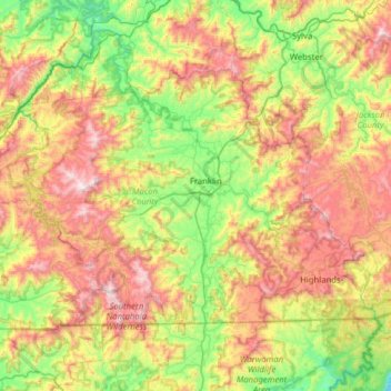
Name: Macon County topographic map, elevation, terrain.
Location: Macon County, North Carolina, United States (34.99331 -83.73818 35.33098 -83.10840)
Average elevation: 2,966 ft
Minimum elevation: 1,371 ft
Maximum elevation: 5,413 ft
North Carolina trails, hiking, mountain biking, running and outdoor activities
Make a donation
Gear up for your next adventure:
As an Amazon Associate, this site earns from qualifying purchases at no extra cost to you.
Other topographic maps
Click on a map to view its topography, its elevation and its terrain.
Appalachian Mountains
United States > North Carolina > Yancey County
The Appalachian Mountains (French: Appalaches), often called the Appalachians, are a system of mountains in eastern to northeastern North America. The Appalachians first formed roughly 480 million years ago during the Ordovician Period. They once reached elevations similar to those of the Alps and the Rocky…
Average elevation: 4,800 ft
Highlands
United States > North Carolina > Macon County > Highlands
Highlands was founded in 1875 after its two founders, Samuel Truman Kelsey and Clinton Carter Hutchinson, drew lines from Chicago to Savannah and from New Orleans to New York City. They felt that the place where these lines met would eventually become a great trading center and commercial crossroads. Highlands…
Average elevation: 3,576 ft
Make a donation
Gear up for your next adventure:
As an Amazon Associate, this site earns from qualifying purchases at no extra cost to you.
Make a donation
Gear up for your next adventure:
As an Amazon Associate, this site earns from qualifying purchases at no extra cost to you.
Make a donation
Gear up for your next adventure:
As an Amazon Associate, this site earns from qualifying purchases at no extra cost to you.
Structure Number Six B Dam
United States > North Carolina > McDowell County
Average elevation: 1,545 ft
Carmel Woods
United States > North Carolina > Mecklenburg County > Charlotte
Average elevation: 633 ft
Make a donation
Gear up for your next adventure:
As an Amazon Associate, this site earns from qualifying purchases at no extra cost to you.
Kuwohi
United States > North Carolina > Swain County
At an elevation of 6,643 feet (2,025 m), it is the highest mountain in the Great Smoky Mountains National Park, the highest point in the state of Tennessee, and the highest point along the 2,192-mile (3,528 km) Appalachian Trail. It is also the third highest point in eastern mainland North America, after Mount…
Average elevation: 5,630 ft
Make a donation
Gear up for your next adventure:
As an Amazon Associate, this site earns from qualifying purchases at no extra cost to you.
Make a donation
Gear up for your next adventure:
As an Amazon Associate, this site earns from qualifying purchases at no extra cost to you.
Elk Knob
United States > North Carolina > Watauga County
Elk Knob is a mountain in the North Carolina High Country, north of the community of Meat Camp. Its elevation reaches 5,538 feet (1,688 m).
Average elevation: 4,469 ft
Cataloochee Valley Viewpoint
United States > North Carolina > Haywood County > Cataloochee
Average elevation: 3,471 ft
Make a donation
Gear up for your next adventure:
As an Amazon Associate, this site earns from qualifying purchases at no extra cost to you.
Ravensford
United States > North Carolina > Swain County > Yellowhill Community
Average elevation: 2,530 ft
Make a donation
Gear up for your next adventure:
As an Amazon Associate, this site earns from qualifying purchases at no extra cost to you.
Orchard Park
United States > North Carolina > Mecklenburg County > Charlotte
Average elevation: 751 ft
Make a donation
Gear up for your next adventure:
As an Amazon Associate, this site earns from qualifying purchases at no extra cost to you.
Make a donation
Gear up for your next adventure:
As an Amazon Associate, this site earns from qualifying purchases at no extra cost to you.
Make a donation
Gear up for your next adventure:
As an Amazon Associate, this site earns from qualifying purchases at no extra cost to you.
Griffith Lakes
United States > North Carolina > Mecklenburg County > Charlotte
Average elevation: 801 ft
Little Switzerland
United States > North Carolina > McDowell County
Little Switzerland is an unincorporated community in McDowell and Mitchell counties of North Carolina, United States. It is located along North Carolina Highway 226A (NC 226A) off the Blue Ridge Parkway, directly north of Marion and south of Spruce Pine. The elevation is 3,468 feet (1,057 m) above sea level.
Average elevation: 3,068 ft
Make a donation
Gear up for your next adventure:
As an Amazon Associate, this site earns from qualifying purchases at no extra cost to you.
Mount Mitchell
United States > North Carolina > Yancey County
Mount Mitchell, known in Cherokee as Attakulla, is the highest peak of the Appalachian Mountains and the highest peak in mainland eastern North America. It is located near Burnsville in Yancey County, North Carolina in the Black Mountain subrange of the Appalachians about 19 miles (31 km) northeast of…
Average elevation: 5,719 ft
Make a donation
Gear up for your next adventure:
As an Amazon Associate, this site earns from qualifying purchases at no extra cost to you.
Buckeye Lake
United States > North Carolina > Watauga County > Beech Mountain
Average elevation: 3,806 ft
Make a donation
Gear up for your next adventure:
As an Amazon Associate, this site earns from qualifying purchases at no extra cost to you.
Make a donation
Gear up for your next adventure:
As an Amazon Associate, this site earns from qualifying purchases at no extra cost to you.
Make a donation
Gear up for your next adventure:
As an Amazon Associate, this site earns from qualifying purchases at no extra cost to you.
Make a donation
Gear up for your next adventure:
As an Amazon Associate, this site earns from qualifying purchases at no extra cost to you.
Lake Raleigh
United States > North Carolina > Wake County > Raleigh > Isle Forest
Average elevation: 341 ft
Make a donation
Gear up for your next adventure:
As an Amazon Associate, this site earns from qualifying purchases at no extra cost to you.
West Smithfield
United States > North Carolina > Johnston County > Smithfield
Average elevation: 141 ft
Make a donation
Gear up for your next adventure:
As an Amazon Associate, this site earns from qualifying purchases at no extra cost to you.
Make a donation
Gear up for your next adventure:
As an Amazon Associate, this site earns from qualifying purchases at no extra cost to you.
Make a donation
Gear up for your next adventure:
As an Amazon Associate, this site earns from qualifying purchases at no extra cost to you.
Make a donation
Gear up for your next adventure:
As an Amazon Associate, this site earns from qualifying purchases at no extra cost to you.
Make a donation
Gear up for your next adventure:
As an Amazon Associate, this site earns from qualifying purchases at no extra cost to you.
Make a donation
Gear up for your next adventure:
As an Amazon Associate, this site earns from qualifying purchases at no extra cost to you.
Arden
United States > North Carolina > Buncombe County > Asheville > Royal Pines
Average elevation: 2,274 ft
Make a donation
Gear up for your next adventure:
As an Amazon Associate, this site earns from qualifying purchases at no extra cost to you.