
Norfolk County topographic map
Interactive map
Click on the map to display elevation.
About this map
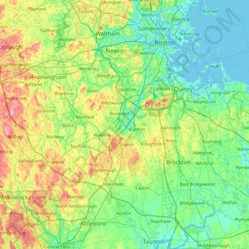
Name: Norfolk County topographic map, elevation, terrain.
Location: Norfolk County, Massachusetts, United States (41.98508 -71.50308 42.35176 -70.73843)
Average elevation: 154 ft
Minimum elevation: -13 ft
Maximum elevation: 607 ft
Massachusetts trails, hiking, mountain biking, running and outdoor activities
Other topographic maps
Click on a map to view its topography, its elevation and its terrain.
Blackwater River
United States > Massachusetts > Essex County > Salisbury > Salisbury Beach
Average elevation: 13 ft
Risingdale
United States > Massachusetts > Berkshire County > Great Barrington
Average elevation: 909 ft
Brookside
United States > Massachusetts > Berkshire County > Great Barrington
Average elevation: 932 ft
Boston
United States > Massachusetts > Suffolk County > Boston
Boston has an area of 89.63 sq mi (232.1 km2)—48.4 sq mi (125.4 km2) (54%) of land and41.2 sq mi (106.7 km2) (46%) of water. The city's official elevation, as measured at Logan International Airport, is 19 ft (5.8 m) above sea level. The highest point in Boston is Bellevue Hill at 330 ft (100 m) above sea…
Average elevation: 85 ft
Northbridge Center
United States > Massachusetts > Worcester County > Northbridge
Average elevation: 407 ft
Freshwater Cove Village
United States > Massachusetts > Essex County > Gloucester
Average elevation: 59 ft
Kenberma
United States > Massachusetts > Plymouth County > Hull > Nantasket Beach
Average elevation: 7 ft
Source Is Shapefile From Town
United States > Massachusetts > Bristol County > Mansfield > Robinsonville
Average elevation: 164 ft
South Hadley Falls
United States > Massachusetts > Hampshire County > South Hadley
Average elevation: 164 ft
Little River Marshes
United States > Massachusetts > Essex County > Gloucester > West Gloucester
Average elevation: 89 ft
Crow Hill Ledges
United States > Massachusetts > Worcester County > Westminster
Average elevation: 961 ft
Charles River Village
United States > Massachusetts > Norfolk County > Needham
Average elevation: 161 ft
Bonny Rigg Corners
United States > Massachusetts > Berkshire County > Becket
Average elevation: 1,476 ft
Hephzibah Heights
United States > Massachusetts > Berkshire County > Monterey
Average elevation: 1,499 ft
Clover Hill Farm Conservation Area
United States > Massachusetts > Berkshire County > Williamstown > Meadowvale
Average elevation: 712 ft
Mittineague
United States > Massachusetts > Hampden County > West Springfield
Average elevation: 161 ft
Medford Hillside
United States > Massachusetts > Middlesex County > Medford > West Medford
Average elevation: 43 ft
Plummers Hill
United States > Massachusetts > Worcester County > Northbridge
Average elevation: 335 ft
Campground Landing
United States > Massachusetts > Barnstable County > Eastham
Average elevation: 20 ft
Phillipston Four Corners
United States > Massachusetts > Worcester County > Phillipston
Average elevation: 1,099 ft
South Royalston
United States > Massachusetts > Worcester County > Royalston
Average elevation: 942 ft
Hobbs Road
United States > Massachusetts > Middlesex County > Wayland > Cochituate
Average elevation: 217 ft
Mount Everett
United States > Massachusetts > Berkshire County
Mount Everett helps divide the watersheds of the Hudson and Housatonic rivers. Its eastern slopes share a larger escarpment with Mount Race and Bear Mountain plus several related summits. This escarpment rises from an elevation around 700 feet in Sheffield's Housatonic Valley at a mean angle of about 20…
Average elevation: 1,841 ft
Opeechee Heights Beach
United States > Massachusetts > Barnstable County > Barnstable > Centerville
Average elevation: 46 ft
Blackburn Village
United States > Massachusetts > Worcester County > Ashburnham
Average elevation: 1,070 ft
Tatnuck
United States > Massachusetts > Worcester County > Worcester > Tatnuck Square
Average elevation: 725 ft