Warren County topographic map
Interactive map
Click on the map to display elevation.
About this map
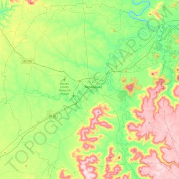
Name: Warren County topographic map, elevation, terrain.
Location: Warren County, Middle Tennessee, Tennessee, United States (35.51352 -85.99093 35.85472 -85.55805)
Average elevation: 1,125 ft
Minimum elevation: 630 ft
Maximum elevation: 2,014 ft
Other topographic maps
Click on a map to view its topography, its elevation and its terrain.
Nashville-Davidson
United States > Tennessee > Davidson County
Nashville-Davidson, features a diverse topography characterized by its position in the Nashville Basin and the Highland Rim. The terrain is predominantly hilly, with elevations ranging from approximately 385 feet at the Cumberland River to around 1,163 feet in areas like Radnor Lake State Natural Area. This…
Average elevation: 604 ft
Johnson City
United States > Tennessee > Washington County
The steep mountains, rolling hills, and valleys surrounding the region are part of the Appalachian Ridge-and-Valley Province, and Johnson City is just west of the Blue Ridge Mountains. Roan Mountain, with an elevation of over 6,000 feet (1,800 m), is approximately 20 miles (32 km) to the southeast of the city.…
Average elevation: 1,683 ft
Crossville
United States > Tennessee > Cumberland County
Crossville is located at the center of Cumberland County at 35°57′15″N 85°1′53″W / 35.95417°N 85.03139°W / 35.95417; -85.03139 (35.954221, -85.031267). The city is situated atop the Cumberland Plateau amidst the headwaters of the Obed River, which slices a gorge north of Crossville en…
Average elevation: 1,814 ft
Chattanooga
United States > Tennessee > Hamilton County
Chattanooga showcases a diverse and striking topography that is defined by its position within the Appalachian region. Nestled between the rugged Ridge-and-Valley Appalachians and the Cumberland Plateau, the city is framed by dramatic hills and valleys, creating a visually compelling landscape. The Tennessee…
Average elevation: 1,086 ft
Mountain City
United States > Tennessee > Johnson County
Mountain City is a town in and the county seat of Johnson County, Tennessee, United States. The population was 2,383 at the 2000 census and 2,531 at the 2010 census. It is the northeasternmost county seat in Tennessee. In addition, at an elevation of 2,418 feet (737 m), it has the distinction of being the…
Average elevation: 2,713 ft
Great Smoky Mountains National Park
United States > Tennessee > Sevier County
Elevations in the park range from about 875 feet (267 m) to 6,643 feet (2,025 m) at the summit of Clingmans Dome. Within the park a total of sixteen mountains reach higher than 5,000 feet (1,520 m).
Average elevation: 2,510 ft
Sevier County
The maximum elevation differential in Sevier County is the greatest in Tennessee, ranging from a high of 6,643 feet (2,025 m) at Clingmans Dome to a low of 850 feet (260 m) at the French Broad River.
Average elevation: 1,965 ft
Monteagle
United States > Tennessee > Grundy County
The town straddles a narrow stretch of the Cumberland Plateau known colloquially as "Monteagle Mountain". This stretch of the plateau is approximately 2 miles (3 km) wide, with steep drop-offs to the northwest and southeast. Monteagle lies at an elevation of just under 2,000 feet (610 m) above sea level. By…
Average elevation: 1,598 ft
McMinnville
United States > Tennessee > Warren County
According to the United States Census Bureau, the city has a total area of 10.0 square miles (26 km2), all land. McMinnville lies at an elevation of 968 feet (295 m), as it sits along the Eastern Highland Rim near the base of the Cumberland Plateau. The city is drained primarily by the Barren Fork, a tributary…
Average elevation: 991 ft
Knoxville
United States > Tennessee > Knox County
According to the United States Census Bureau, the city has a total area of 104.2 square miles (269.8 km2), of which 98.5 square miles (255.2 km2) is land and 5.6 square miles (14.6 km2), or 5.42%, is water. Elevations range from just over 800 feet (240 m) along the riverfront to just over 1,000 feet (300 m) on…
Average elevation: 1,007 ft
Staffordtown
United States > Tennessee > Polk County > Copperhill
Staffordtown is situated in the scenic Appalachian region, characterized by its rugged terrain and lush forests. The area is marked by steep hills and rolling valleys that define the landscape, with elevations ranging from around 1,500 to 3,000 feet above sea level. The surrounding mountains, part of the…
Average elevation: 1,568 ft
Cleveland
United States > Tennessee > Bradley County
The area's terrain is made up of parallel ridges, including Candies Creek Ridge (also called Clingan Ridge), Mouse Creek/Lead Mine Ridge, and Blue Springs Ridge, which are extensions of the Appalachian Mountains (specifically part of the Ridge-and-Valley Appalachians) that run approximately north-northeast…
Average elevation: 866 ft
Greene County
According to the U.S. Census Bureau, the county has a total area of 624 square miles (1,620 km2), of which 622 square miles (1,610 km2) is land and 2.0 square miles (5.2 km2) (0.3%) is water. Most of Greene County is located within the Ridge-and-Valley Appalachians, a range characterized by long, narrow ridges…
Average elevation: 1,611 ft
Spring Valley
United States > Tennessee > Hamilton County > Chattanooga > Red Bank
Average elevation: 1,047 ft
Townsend
United States > Tennessee > Blount County
Just to the north and west of Townsend, the Foothills Parkway is a national parkway that traverses Chilhowee Mountain and offers multiple scenic overlooks at high elevations, with views of the Smokies to the south and the Tennessee Valley and Cumberland Plateau to the north and west. As of 2016, road…
Average elevation: 1,234 ft
Elizabethton
United States > Tennessee > Carter County > Elizabethton > Elizabethton
The elevation at Elizabethton Municipal Airport is 1,593 feet (486 m) ASL (the highest point of elevation in Carter County is at Roan Mountain with an elevation of 6,285 feet (1,916 m) ASL), and the airport is located on the eastern side of the city along State Highway 91 Stoney Creek Exit. Elizabethton is…
Average elevation: 1,729 ft
Oak Ridge
United States > Tennessee > Anderson County
The highest point is Melton Hill (35°54′35″N 84°18′19″W / 35.90962°N 84.30525°W / 35.90962; -84.30525) on the DOE reservation, at elevation 1,356 feet (413 m).
Average elevation: 951 ft
Bristol
United States > Tennessee > Sullivan County
Like much of the rest of the state, Bristol has a humid subtropical climate (Köppen climate classification: Cfa), although with significantly cooler temperatures, especially in the summer, due to elevation; it is part of USDA hardiness zone 6b, with areas to the southwest falling in zone 7a. The normal…
Average elevation: 1,781 ft
Newport
United States > Tennessee > Cocke County
In 1880, Canadian-born entrepreneur Alexander Arthur (1846–1912), representing the Scottish Carolina Timber and Land Company, arrived in Newport with ambitious plans to log the Pigeon valley. Arthur's plan called for the construction of a series of dams and booms which would be used to move logs from the…
Average elevation: 1,220 ft