
White County topographic map
Interactive map
Click on the map to display elevation.
About this map
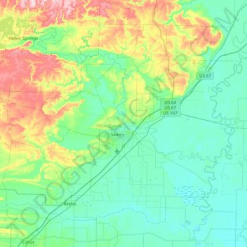
Name: White County topographic map, elevation, terrain.
Location: White County, Arkansas, United States (35.02064 -92.11975 35.53406 -91.34533)
Average elevation: 364 ft
Minimum elevation: 161 ft
Maximum elevation: 1,089 ft
Arkansas trails, hiking, mountain biking, running and outdoor activities
Other topographic maps
Click on a map to view its topography, its elevation and its terrain.
Magazine Mountain
United States > Arkansas > Logan County
Mount Magazine is often called "the highest point between the Alleghenies and the Rockies" (there are mountains located in the Trans-Pecos region of far-west Texas which exceed Mount Magazine in elevation and prominence, although the Trans-Pecos region lies so far south of the Rockies, that region arguably…
Average elevation: 2,198 ft