
Centre County topographic map
Click on the map to display elevation.
Centre County
Centre County has a humid continental climate (Dfb/Dfa at lower elevations).
About this map
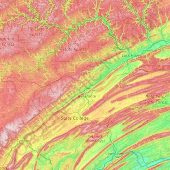
Name: Centre County topographic map, elevation, terrain.
Location: Centre County, Pennsylvania, United States (40.69156 -78.37667 41.25288 -77.14346)
Average elevation: 1,401 ft
Minimum elevation: 400 ft
Maximum elevation: 2,612 ft
Pennsylvania trails, hiking, mountain biking, running and outdoor activities
Other topographic maps
Click on a map to view its topography, its elevation and its terrain.
Limerick
United States > Pennsylvania > Montgomery County > Limerick Township
Average elevation: 282 ft
Albrightsville
United States > Pennsylvania > Carbon County > Kidder Township
Average elevation: 1,634 ft
East Texas
United States > Pennsylvania > Lehigh County > Lower Macungie Township
Average elevation: 413 ft
Intercourse
United States > Pennsylvania > Lancaster County > Leacock Township
Average elevation: 417 ft
Wimmers
United States > Pennsylvania > Lackawanna County > Jefferson Township > Mount Cobb
Average elevation: 1,624 ft
Dingmans Ferry
United States > Pennsylvania > Pike County > Delaware Township
Average elevation: 630 ft
Teepleville
United States > Pennsylvania > Crawford County > Richmond Township
Average elevation: 1,266 ft
Pricetown
United States > Pennsylvania > Berks County > Ruscombmanor Township
Average elevation: 784 ft
New Enterprise
United States > Pennsylvania > Bedford County > South Woodbury Township
Average elevation: 1,302 ft
Saint Benedict
United States > Pennsylvania > Cambria County > West Carroll Township
Average elevation: 1,909 ft
Old Forge
United States > Pennsylvania > Franklin County > Quincy Township
Average elevation: 1,273 ft
Fogelsville
United States > Pennsylvania > Lehigh County > Upper Macungie Township
Average elevation: 509 ft
Ricketts Glen State Park
United States > Pennsylvania > Luzerne County > Fairmount Township
The state's original plans for the new park included building an inn, an 18-hole golf course and country club, and a winter sports complex for skiing, ice boating, and tobogganing, as well as a beach with bathing facilities, cabins, and a tent camping area. Only the last three were actually built, all south of…
Average elevation: 1,929 ft
Stevens Point
United States > Pennsylvania > Susquehanna County > Harmony Township
Average elevation: 1,424 ft
Stiefler Corner
United States > Pennsylvania > Bedford County > Kimmel Township
Average elevation: 1,706 ft
Valley Forge
United States > Pennsylvania > Chester County > Schuylkill Township
Average elevation: 256 ft
Kunkletown
United States > Pennsylvania > Monroe County > Eldred Township
Kunkletown is an unincorporated community in Eldred Township, Monroe County, Pennsylvania, United States. It is located at an elevation of 531 feet. It is at ZIP Code 18058.
Average elevation: 735 ft
Blakeslee
United States > Pennsylvania > Monroe County > Tobyhanna Township
Average elevation: 1,654 ft
Bald Mountain
United States > Pennsylvania > Luzerne County > Bear Creek Township
Average elevation: 1,821 ft
Churchville
United States > Pennsylvania > Northampton County > Forks Township
Average elevation: 423 ft
Pikeland
United States > Pennsylvania > Chester County > West Pikeland Township > Chester Springs
Average elevation: 351 ft
Lords Valley
United States > Pennsylvania > Pike County > Blooming Grove Township
Average elevation: 1,352 ft
Strabane
United States > Pennsylvania > Washington County > North Strabane Township
Average elevation: 1,079 ft
Hillside
United States > Pennsylvania > Lehigh County > South Whitehall Township
Average elevation: 499 ft
Abbot Ridge
United States > Pennsylvania > Bedford County > Liberty Township
Average elevation: 958 ft
Freemont
United States > Pennsylvania > Chester County > West Nottingham Township
Average elevation: 377 ft
Vance
United States > Pennsylvania > Washington County > South Strabane Township
Average elevation: 1,217 ft
Armbrust
United States > Pennsylvania > Westmoreland County > Hempfield Township
Average elevation: 1,083 ft
Mainesburg
United States > Pennsylvania > Tioga County > Sullivan Township
Average elevation: 1,565 ft
Mount Nebo Park
United States > Pennsylvania > Monroe County > East Stroudsburg > Twin Falls
Average elevation: 607 ft
Russell
United States > Pennsylvania > Warren County > Pine Grove Township
Average elevation: 1,450 ft
Cornwells Heights
United States > Pennsylvania > Bucks County > Bensalem Township
Average elevation: 52 ft
Cowden
United States > Pennsylvania > Washington County > Cecil Township > Cecil
Average elevation: 1,135 ft
Idaho
United States > Pennsylvania > Armstrong County > South Bend Township
Average elevation: 1,112 ft
Keown Station
United States > Pennsylvania > Allegheny County > Ross Township
Average elevation: 1,129 ft
Glenshaw
United States > Pennsylvania > Allegheny County > Shaler Township
Average elevation: 1,024 ft
Stony Creek Mills
United States > Pennsylvania > Berks County > Lower Alsace Township > Pennside
Average elevation: 630 ft
Blue Knob
United States > Pennsylvania > Bedford County > Pavia Township
Blue Knob (elevation 3,146 feet (959 m)) is a summit in the eastern United States with a broad dome that is the northernmost 3,000-footer in the Allegheny Mountains. It is the highest point in Bedford County, Pennsylvania.
Average elevation: 2,598 ft
Sinnemahoning
United States > Pennsylvania > Cameron County > Gibson Township
Average elevation: 1,332 ft
English Center
United States > Pennsylvania > Lycoming County > Pine Township
Average elevation: 1,457 ft
Tyrrel Farm Corners
United States > Pennsylvania > Venango County > Allegheny Township
Average elevation: 1,568 ft
Orvilla
United States > Pennsylvania > Montgomery County > Hatfield Township
Average elevation: 328 ft
Fort Hunter
United States > Pennsylvania > Dauphin County > Middle Paxton Township
Average elevation: 489 ft
Fisherville
United States > Pennsylvania > Dauphin County > Jackson Township
Average elevation: 604 ft
Spring Run
United States > Pennsylvania > Franklin County > Fannett Township
Average elevation: 955 ft
Green Village
United States > Pennsylvania > Franklin County > Greene Township
Average elevation: 679 ft
Normalville
United States > Pennsylvania > Fayette County > Springfield Township
Average elevation: 1,594 ft
Chalkhill
United States > Pennsylvania > Fayette County > Wharton Township
Average elevation: 2,044 ft
Arnold City
United States > Pennsylvania > Fayette County > Washington Township
Average elevation: 994 ft
Three Tuns
United States > Pennsylvania > Montgomery County > Upper Dublin Township > Maple Glen
Average elevation: 331 ft
Hidden Valley
United States > Pennsylvania > Montgomery County > Upper Merion Township
Average elevation: 154 ft
Newfoundland
United States > Pennsylvania > Wayne County > Dreher Township
Average elevation: 1,496 ft
Strafford
United States > Pennsylvania > Chester County > Tredyffrin Township
Average elevation: 436 ft
West Pittsburg
United States > Pennsylvania > Lawrence County > Taylor Township
Average elevation: 915 ft
Dilltown
United States > Pennsylvania > Indiana County > East Wheatfield Township
Average elevation: 1,555 ft
Robinson
United States > Pennsylvania > Indiana County > West Wheatfield Township
Average elevation: 1,302 ft
Hazelton Mills
United States > Pennsylvania > McKean County > Bradford Township
Average elevation: 1,962 ft
Tobyhanna
United States > Pennsylvania > Monroe County > Coolbaugh Township
Average elevation: 1,936 ft
Bear Rocks
United States > Pennsylvania > Fayette County > Bullskin Township
Average elevation: 1,873 ft
Barnesville
United States > Pennsylvania > Schuylkill County > Rush Township
Average elevation: 1,175 ft
Mount Bethel
United States > Pennsylvania > Northampton County > Upper Mount Bethel Township
Average elevation: 512 ft