Geolocate

New Market topographic map

Click on the map to display elevation.

About this map

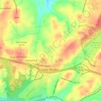
Name: New Market topographic map, elevation, terrain.

Location: New Market, Frederick County, Maryland, 21174, United States (39.37109 -77.29512 39.40446 -77.25676)

Average elevation: 499 ft

Minimum elevation: 367 ft

Maximum elevation: 591 ft

Frederick County trails, hiking, mountain biking, running and outdoor activities

Other topographic maps

Click on a map to view its topography, its elevation and its terrain.

Point of Rocks

United States > Maryland > Frederick County

Average elevation: 338 ft

Flat Run

United States > Maryland > Frederick County > Emmitsburg

Average elevation: 453 ft

Bartonsville

United States > Maryland > Frederick County

Average elevation: 387 ft

Linganore

United States > Maryland > Frederick County

Average elevation: 492 ft

Rosedale

United States > Maryland > Frederick County > Frederick

Average elevation: 328 ft

Doubs

United States > Maryland > Frederick County > Adamstown

Average elevation: 318 ft

Buckeystown

United States > Maryland > Frederick County

Average elevation: 289 ft

Graceham

United States > Maryland > Frederick County

Average elevation: 430 ft

Lewistown

United States > Maryland > Frederick County

Average elevation: 404 ft

Libertytown

United States > Maryland > Frederick County

Average elevation: 528 ft

Sabillasville

United States > Maryland > Frederick County

Average elevation: 1,217 ft

Spring Ridge

United States > Maryland > Frederick County

Average elevation: 381 ft

Rocky Ridge

United States > Maryland > Frederick County

Average elevation: 374 ft

Tuscarora

United States > Maryland > Frederick County

Average elevation: 282 ft

Copper Oaks

United States > Maryland > Frederick County > Woodsboro

Average elevation: 433 ft

Braddock

United States > Maryland > Frederick County

Average elevation: 571 ft

Hickory Hill

United States > Maryland > Frederick County

Average elevation: 499 ft

Urbana

United States > Maryland > Frederick County

Average elevation: 430 ft

Adamstown

United States > Maryland > Frederick County

Average elevation: 318 ft

Westwood

United States > Maryland > Frederick County

Average elevation: 449 ft

Knoxville

United States > Maryland > Frederick County

Average elevation: 466 ft

Jefferson

United States > Maryland > Frederick County

Average elevation: 568 ft

Frederick

United States > Maryland > Frederick County > Frederick

Average elevation: 541 ft

Bells Mill

United States > Maryland > Frederick County > Bells Mill

Average elevation: 394 ft

Sunday

United States > Maryland > Frederick County > Sunday

Average elevation: 564 ft

Colebrook

United States > Maryland > Frederick County > Colebrook

Average elevation: 518 ft

Monrovia

United States > Maryland > Frederick County

Average elevation: 502 ft

Indian Springs

United States > Maryland > Frederick County > Frederick

Terrain in the area is generally rugged with elevations between 600 and 1,900 feet (580 m) above sea level, the landscape being primarily wooded. The terrain here differs greatly from the neighboring Hagerstown Valley, where elevations average less than 650' and is characterized by fertile, gently rolling…

Average elevation: 469 ft

Gear up for your next adventure:

💧Water Purification System - Clean water on the trail with reliable purifiers
🔭Compact Binoculars - HD vision for scouting terrain and identifying distant landmarks
🧭Compass with Lanyard - Easy‑carry compass for navigation
🎒Day Hiking Backpack - Lightweight backpack perfect for day trips and outdoor adventures
🧢Outdoor Hiking Hat - Sun protection hat for outdoor explorers

As an Amazon Associate, this site earns from qualifying purchases at no extra cost to you.