
嵩明县 topographic map
Interactive map
Click on the map to display elevation.
About this map
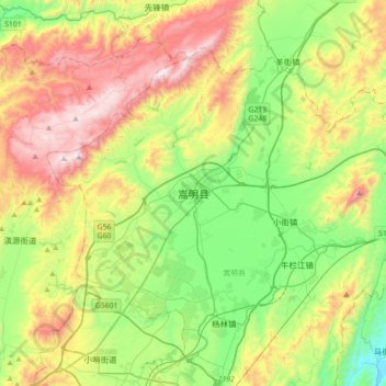
Name: 嵩明县 topographic map, elevation, terrain.
Location: 嵩明县, 昆明市, 云南省, 中国 (25.17407 102.87621 25.49407 103.19621)
Average elevation: 6,913 ft
Minimum elevation: 5,479 ft
Maximum elevation: 9,206 ft
Other topographic maps
Click on a map to view its topography, its elevation and its terrain.
西双版纳热带植物园-百竹园
西双版纳热带植物园-百竹园, 勐仑镇, 勐腊县, 西双版纳傣族自治州, 云南省, 666100, 中国
Average elevation: 1,834 ft