
British Isles topographic map
Interactive map
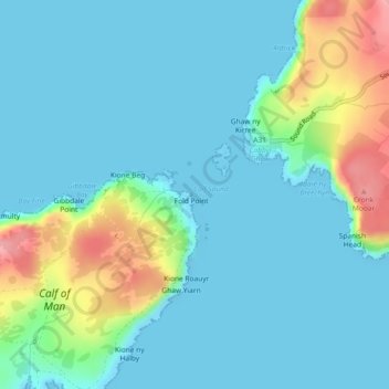
Click on the map to display elevation.
About this map
Name: British Isles topographic map, elevation, terrain.
Location: British Isles, Isle of Man (54.05995 -4.80005 54.06005 -4.79995)
Average elevation: 82 ft
Minimum elevation: -3 ft
Maximum elevation: 394 ft
The oldest rocks are 2.7 billion years old and are found in Ireland, Wales and the northwest of Scotland. During the Silurian period, the north-western regions collided with the south-east, which had been part of a separate continental landmass. The topography of the islands is modest in scale by global standards. Ben Nevis, the highest mountain, rises to only 1,345 metres (4,413 ft), and Lough Neagh, which is notably larger than other lakes in the island group, covers 390 square kilometres (151 sq mi). The climate is temperate marine, with cool winters and warm summers. The North Atlantic drift brings significant moisture and raises temperatures 11 °C (20 °F) above the global average for the latitude. This led to a landscape that was long dominated by temperate rainforest, although human activity has since cleared the vast majority of forest cover. The region was re-inhabited after the last glacial period of Quaternary glaciation, by 12,000 BC, when Great Britain was still part of a peninsula of the European continent. Ireland may have been connected to Great Britain by way of an ice bridge before 14,000 BC, and was not inhabited until after 8000 BC. Great Britain became an island by 7000 BC with the flooding of Doggerland.
Other topographic maps
Click on a map to view its topography, its elevation and its terrain.
Ballasalla
Isle of Man > Rushen > Malew
Ballasalla, Malew, Rushen, Isle of Man
Average elevation: 128 ft
Yellow Stone
Isle of Man > Ayre > Lezayre
Yellow Stone, Lezayre, Ayre, Isle of Man
Average elevation: 1,335 ft
Ronague
Isle of Man > Rushen > Arbory > Ronague
Ronague, Arbory, Rushen, IM9 4HQ, Isle of Man
Average elevation: 492 ft
Douglas Head
Douglas Head, Braddan, Middle, IM1 5BX, Isle of Man
Average elevation: 72 ft