
Middle topographic map
Interactive map
Click on the map to display elevation.
About this map
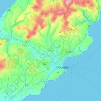
Name: Middle topographic map, elevation, terrain.
Location: Middle, Isle of Man (54.09102 -4.61259 54.26594 -4.42056)
Average elevation: 400 ft
Minimum elevation: 0 ft
Maximum elevation: 2,028 ft
Other topographic maps
Click on a map to view its topography, its elevation and its terrain.
Ballasalla
Isle of Man > Rushen > Malew
Ballasalla, Malew, Rushen, Isle of Man
Average elevation: 128 ft
Yellow Stone
Isle of Man > Ayre > Lezayre
Yellow Stone, Lezayre, Ayre, Isle of Man
Average elevation: 1,335 ft
Ronague
Isle of Man > Rushen > Arbory > Ronague
Ronague, Arbory, Rushen, IM9 4HQ, Isle of Man
Average elevation: 492 ft
Douglas Head
Douglas Head, Braddan, Middle, IM1 5BX, Isle of Man
Average elevation: 72 ft