
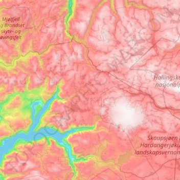
Ulvik topographic map
Interactive map
Click on the map to display elevation.
About this map
Name: Ulvik topographic map, elevation, terrain.
Location: Ulvik, Vestland, Norvège (60.46848 6.75109 60.74084 7.73211)
Average elevation: 3,714 ft
Minimum elevation: 0 ft
Maximum elevation: 6,198 ft
Other topographic maps
Click on a map to view its topography, its elevation and its terrain.
Preikestolen
Preikestolen, Osterøy, Vestland, 5284, Norvège
Average elevation: 860 ft
Vossavangen
Norvège > Vestland > Vossavangen
Vossavangen, Voss herad, Vestland, 5701, Norvège
Average elevation: 1,155 ft