
Gudvangen topographic map
Interactive map
Click on the map to display elevation.
About this map
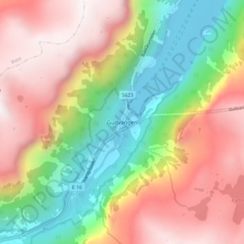
Name: Gudvangen topographic map, elevation, terrain.
Location: Gudvangen, Aurland, Vestland, 5747, Norvège (60.85911 6.81963 60.89911 6.85963)
Average elevation: 2,362 ft
Minimum elevation: 0 ft
Maximum elevation: 4,846 ft
Other topographic maps
Click on a map to view its topography, its elevation and its terrain.
Preikestolen
Preikestolen, Osterøy, Vestland, 5284, Norvège
Average elevation: 860 ft
Vossavangen
Norvège > Vestland > Vossavangen
Vossavangen, Voss herad, Vestland, 5701, Norvège
Average elevation: 1,155 ft