
Osterøy topographic map
Interactive map
Click on the map to display elevation.
About this map
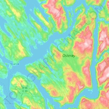
Name: Osterøy topographic map, elevation, terrain.
Location: Osterøy, Vestland, Norvège (60.42541 5.31743 60.71644 5.72294)
Average elevation: 640 ft
Minimum elevation: -7 ft
Maximum elevation: 2,943 ft
Other topographic maps
Click on a map to view its topography, its elevation and its terrain.
Preikestolen
Preikestolen, Osterøy, Vestland, 5284, Norvège
Average elevation: 860 ft
Vossavangen
Norvège > Vestland > Vossavangen
Vossavangen, Voss herad, Vestland, 5701, Norvège
Average elevation: 1,155 ft