
Husavik topographic map
Interactive map
Click on the map to display elevation.
About this map
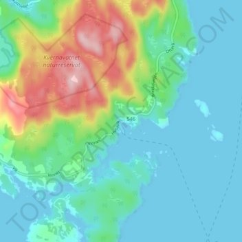
Name: Husavik topographic map, elevation, terrain.
Location: Husavik, Austevoll, Vestland, 5396, Norvège (59.99912 5.25847 60.03912 5.29847)
Average elevation: 177 ft
Minimum elevation: -3 ft
Maximum elevation: 702 ft
Other topographic maps
Click on a map to view its topography, its elevation and its terrain.
Preikestolen
Preikestolen, Osterøy, Vestland, 5284, Norvège
Average elevation: 860 ft
Vossavangen
Norvège > Vestland > Vossavangen
Vossavangen, Voss herad, Vestland, 5701, Norvège
Average elevation: 1,155 ft