
Høyanger topographic map
Interactive map
Click on the map to display elevation.
About this map
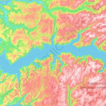
Name: Høyanger topographic map, elevation, terrain.
Location: Høyanger, Vestland, Norvège (60.95150 5.37386 61.29782 6.41112)
Average elevation: 1,732 ft
Minimum elevation: -3 ft
Maximum elevation: 4,472 ft
Other topographic maps
Click on a map to view its topography, its elevation and its terrain.
Preikestolen
Preikestolen, Osterøy, Vestland, 5284, Norvège
Average elevation: 860 ft
Vossavangen
Norvège > Vestland > Vossavangen
Vossavangen, Voss herad, Vestland, 5701, Norvège
Average elevation: 1,155 ft