
Arezzo topographic map
Click on the map to display elevation.
About this map
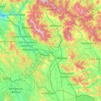
Name: Arezzo topographic map, elevation, terrain.
Location: Arezzo, Tuscany, Italy (43.15634 11.39738 43.87790 12.37227)
Average elevation: 1,558 ft
Minimum elevation: 171 ft
Maximum elevation: 5,387 ft
Other topographic maps
Click on a map to view its topography, its elevation and its terrain.
Lari
Lari is a walled mountaintop frazione, or hamlet, in the comune of Casciana Terme Lari, 60 kilometres (37 mi) southwest of Florence and 25 kilometres (16 mi) southeast of Pisa, in the Tuscany region of Italy. The municipal seat of its comune, Lari dates from at least the 9th century BC, a fact established by…
Average elevation: 262 ft
Mount Amiata
Italy > Tuscany > Siena > Abbadia San Salvatore
The region is included in the comuni of Abbadia San Salvatore, Arcidosso, Castel del Piano, Piancastagnaio, Santa Fiora and Seggiano, all located between 600 and 800 metres of altitude.
Average elevation: 4,675 ft
Populonia
Italy > Tuscany > Livorno > Piombino
In geology, the "Tuscan metallogenic province" derived from volcanic intrusions into southern Etruria due to extension of the crust there (which also created a karst topography in western Italy) from the late Miocene to the Pleistocene. This process emplaced iron oxide deposits on Elba, pyrite in southern…
Average elevation: 112 ft