Geolocate

Jiwaka topographic map

Click on the map to display elevation.

Jiwaka

"Jiwaka" is a portmanteau word combining the first two letters each from the word Jimi, Waghi and Kambia. Jimi, Waghi and Kambia denote the topographical landscape referencing the Valley (Waghi Valley) and the mountain ranges at the north (Jimi) and south (Kambia).

Wikipedia (CC-BY-SA 3.0)

About this map

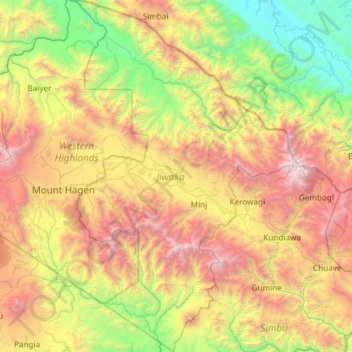
Name: Jiwaka topographic map, elevation, terrain.

Location: Jiwaka, Highlands Region, Papua New Guinea (-6.40518 144.26945 -5.21953 145.02958)

Average elevation: 5,131 ft

Minimum elevation: 171 ft

Maximum elevation: 14,528 ft

Other topographic maps

Click on a map to view its topography, its elevation and its terrain.

Paikela

Papua New Guinea > Hela > Tari-Pori District

Average elevation: 5,663 ft

Supi

Papua New Guinea > Enga > Kandep District

Average elevation: 8,022 ft

Saina Town

Papua New Guinea > Simbu > Kundiawa District > Mu

Average elevation: 6,165 ft

Kundiawa

Papua New Guinea > Simbu

Kundiawa has a relatively cool tropical rainforest climate (Köppen Af), bordering on a subtropical highland climate (Cfb) due to altitude. It features mild mornings, very warm but not hot afternoons, and heavy rainfall year round.

Average elevation: 6,814 ft

Afore

Papua New Guinea > Oro

Average elevation: 2,129 ft

Mount Wilhelm

Papua New Guinea > Jiwaka

Average elevation: 13,366 ft

Kapuna

Papua New Guinea > Gulf

Average elevation: 16 ft

Nui Timin Island

Papua New Guinea > Madang > Madang

Average elevation: 10 ft

Ulawun

Papua New Guinea > West New Britain

Average elevation: 5,594 ft

Kainantu

Papua New Guinea > Eastern Highlands > Kainantu District

A narrow south-east-trending dissected plateau dominates area to the south; it forms the watershed between rivers draining north to the Markham-Ramu Graben, and those draining south to the Papuan coast. The plateau ranges in elevation between 7,500 feet (2,300 m) and 8,000 feet (2,400 m) above sea level, and…

Average elevation: 5,341 ft

Map

Papua New Guinea > Southern Highlands > Mendi District

Average elevation: 6,093 ft

Goroka

Papua New Guinea > Eastern Highlands > Goroka District

Goroka has a subtropical highland climate (Cfb). Due to altitude Goroka features warm to very warm afternoons and cool to mild mornings year-round, with heavy rainfall most of the year and low rainfall from June to September.

Average elevation: 6,201 ft

Kranket Island

Papua New Guinea > Madang > Panutibun

Average elevation: 3 ft

Kainantu

Papua New Guinea > Eastern Highlands > Kainantu

A narrow south-east-trending dissected plateau dominates area to the south; it forms the watershed between rivers draining north to the Markham-Ramu Graben, and those draining south to the Papuan coast. The plateau ranges in elevation between 7,500 feet (2,300 m) and 8,000 feet (2,400 m) above sea level, and…

Average elevation: 5,341 ft

Homu

Papua New Guinea > Eastern Highlands

Average elevation: 6,637 ft

Kimbe

Papua New Guinea > West New Britain

Average elevation: 305 ft

Wakon

Papua New Guinea > Madang

Average elevation: 833 ft

Mount Hagen

Papua New Guinea > Western Highlands

Mount Hagen (Tok Pisin: Maun Hagen) is the third largest city in Papua New Guinea, with a population of 46,250. It is the capital of the Western Highlands Province and is located in the large fertile Wahgi Valley in central mainland Papua New Guinea, at an elevation of 1,677 m (5,502 ft).

Average elevation: 6,247 ft

Kauwi

Papua New Guinea > Jiwaka

Average elevation: 5,302 ft

Lae

Papua New Guinea > Morobe > Lae District

Average elevation: 531 ft

Pomio

Papua New Guinea > East New Britain

Average elevation: 430 ft

Goilala District

Papua New Guinea > Central

Average elevation: 3,261 ft

Kandep District

Papua New Guinea > Enga

Average elevation: 6,572 ft

Kokoda

Papua New Guinea > Oro

Average elevation: 1,447 ft

Tabubil

Papua New Guinea > Western

Average elevation: 1,939 ft

Owen Stanley Range

Papua New Guinea > Central

Average elevation: 8,038 ft

Popondetta

Papua New Guinea > Oro

Average elevation: 594 ft

Kundiawa

Papua New Guinea > Simbu

Kundiawa has a relatively cool tropical rainforest climate (Köppen Af), bordering on a subtropical highland climate (Cfb) due to altitude. It features mild mornings, very warm but not hot afternoons, and heavy rainfall year round.

Average elevation: 6,814 ft

Madang

Papua New Guinea > Madang

Average elevation: 207 ft

Wewak

Papua New Guinea > East Sepik

Average elevation: 318 ft

Huon Gulf

Papua New Guinea > Morobe

Huon Gulf is a large gulf in eastern Papua New Guinea. It is bordered by Huon Peninsula in the north. Both are named after French explorer Jean-Michel Huon de Kermadec. Huon Gulf is a part of the Solomon Sea. Its northern boundary is marked by Cape Cretin, southern by Cape Longerue. The coast, which quickly…

Average elevation: 0 ft

Garaina

Papua New Guinea > Morobe

Average elevation: 2,618 ft

Mount Bosavi

Papua New Guinea > Southern Highlands

Average elevation: 6,220 ft

Ororogaivara

Papua New Guinea > Central > Goilala District

Average elevation: 5,961 ft

Menyamya

Papua New Guinea > Morobe > Menyamya District

Average elevation: 4,692 ft

Kavieng

Papua New Guinea > New Ireland

Average elevation: 7 ft

Kompiam

Papua New Guinea > Enga

Average elevation: 5,787 ft

Lorengau

Papua New Guinea > Manus

Average elevation: 79 ft

Homu

Papua New Guinea > Eastern Highlands

Average elevation: 6,637 ft

Popondetta

Papua New Guinea > Oro

Average elevation: 594 ft

Aset

Papua New Guinea > Madang

Average elevation: 3,586 ft

Dumun Kul

Papua New Guinea > Simbu > Kundiawa District

Average elevation: 6,512 ft

Kauwi

Papua New Guinea > Jiwaka

Average elevation: 5,302 ft

Porgera

Papua New Guinea > Enga

Average elevation: 7,917 ft

Sumel

Papua New Guinea > West New Britain

Average elevation: 230 ft

Kokopo

Papua New Guinea > East New Britain

Average elevation: 171 ft

Goroka

Papua New Guinea > Eastern Highlands > Goroka District

Goroka has a subtropical highland climate (Cfb). Due to altitude Goroka features warm to very warm afternoons and cool to mild mornings year-round, with heavy rainfall most of the year and low rainfall from June to September.

Average elevation: 6,201 ft

Lalaura

Papua New Guinea > Central

Average elevation: 7 ft

Urup

Papua New Guinea > Jiwaka

Average elevation: 4,993 ft

Kandrian

Papua New Guinea > West New Britain

Average elevation: 200 ft

Finschhafen

Papua New Guinea > Morobe

Average elevation: 148 ft

Lae

Papua New Guinea > Morobe > Lae District

Average elevation: 531 ft

Lake Timba

Papua New Guinea > Hela > Komo-Margarima District > Haipita

Average elevation: 7,687 ft

Ngor

Papua New Guinea > Madang

Average elevation: 118 ft

Eora Creek

Papua New Guinea > Oro

Average elevation: 5,659 ft

Kupiano

Papua New Guinea > Central

Average elevation: 16 ft

Porgera

Papua New Guinea > Enga

Average elevation: 7,917 ft

Ilo'ilo

Papua New Guinea > Milne Bay

Average elevation: 16 ft

Butibum River

Papua New Guinea > Morobe > Lae District > Lae

Average elevation: 233 ft

Kerema

Papua New Guinea > Gulf

Average elevation: 253 ft

Ok Menga

Papua New Guinea > Western > Migalsimbip

Average elevation: 1,883 ft

Paup

Papua New Guinea > Sandaun

Average elevation: 23 ft

Wabag

Papua New Guinea > Enga

Average elevation: 8,173 ft

xxx

Papua New Guinea > East Sepik

Average elevation: 112 ft

Mount Turu

Papua New Guinea > East Sepik

Average elevation: 2,799 ft

Kovelo

Papua New Guinea > Oro

Average elevation: 1,962 ft

Buso River

Papua New Guinea > Morobe > Busung

Average elevation: 3,350 ft

Wakia

Papua New Guinea > Southern Highlands > Mendi District

Average elevation: 6,263 ft

Wampar LLG Station

Papua New Guinea > Morobe

Average elevation: 197 ft

Kagamuga

Papua New Guinea > Western Highlands

Average elevation: 5,344 ft

Waigani

Papua New Guinea > Simbu > Kundiawa District > Kel

Average elevation: 5,440 ft

Yamb

Papua New Guinea > Enga > Kandep District

Average elevation: 7,648 ft

Mondia

Papua New Guinea > Simbu > Chuave District

Average elevation: 6,578 ft

Perui

Papua New Guinea > Simbu

Average elevation: 6,778 ft

Goroka

Papua New Guinea > Eastern Highlands > Goroka District

Goroka has a subtropical highland climate (Cfb). Due to altitude Goroka features warm to very warm afternoons and cool to mild mornings year-round, with heavy rainfall most of the year and low rainfall from June to September.

Average elevation: 6,201 ft

Mount Ambunti

Papua New Guinea > East Sepik > Ambunti

Average elevation: 650 ft

Kamtai

Papua New Guinea > Simbu > Kundiawa District

Average elevation: 6,283 ft

Gear up for your next adventure:

🛌Ultralight Sleeping Bags - Compact down bags for cold nights in the wilderness
👓Polarized Sunglasses - Outdoor sunglasses for glare reduction
🛠️Outdoor Gear Repair Kit - Essential tools to fix gear on the trail
🩳Quick‑Dry Hiking Shorts - Comfortable and quick‑dry shorts for summer hiking
🔥Camping Stove - Portable stove for camping and backcountry cooking

As an Amazon Associate, this site earns from qualifying purchases at no extra cost to you.