
Make a donation
Gear up for your next adventure:
As an Amazon Associate, this site earns from qualifying purchases at no extra cost to you.
Hoeselt topographic map
Click on the map to display elevation.
Make a donation
Gear up for your next adventure:
As an Amazon Associate, this site earns from qualifying purchases at no extra cost to you.
About this map
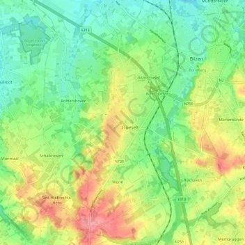
Name: Hoeselt topographic map, elevation, terrain.
Location: Hoeselt, Bilzen-Hoeselt, Tongeren, Limburg, 3730, België (50.81441 5.44045 50.88843 5.51333)
Average elevation: 236 ft
Minimum elevation: 121 ft
Maximum elevation: 407 ft
Make a donation
Gear up for your next adventure:
As an Amazon Associate, this site earns from qualifying purchases at no extra cost to you.
Other topographic maps
Click on a map to view its topography, its elevation and its terrain.
Offelken
België > Limburg > Tongeren > Tongeren
Offelken ligt in Droog-Haspengouw. De hoogte varieert tussen 88 en 98 meter. De kern van het gehucht ligt ten zuiden van de aftakking van de Oude Jeker. Deze waterloop werd aangelegd door de mens en heeft een lengte van ongeveer drie kilometer.
Average elevation: 315 ft
Make a donation
Gear up for your next adventure:
As an Amazon Associate, this site earns from qualifying purchases at no extra cost to you.
Make a donation
Gear up for your next adventure:
As an Amazon Associate, this site earns from qualifying purchases at no extra cost to you.
Kesselt
België > Limburg > Tongeren > Lanaken > Veldwezelt
Kesselt behoort tot de streek Droog-Haspengouw. Het ligt geologisch gezien op een plateau, dat omwille van de unieke kleisoort genoemd is naar het dorp (plateau van Kesselt). Het dorp geniet dan ook enige regionale bekendheid omwille van haar steenbakkerij. Kesselt ligt op een hoogte van ongeveer 98 meter. Ten…
Average elevation: 276 ft
Make a donation
Gear up for your next adventure:
As an Amazon Associate, this site earns from qualifying purchases at no extra cost to you.
Make a donation
Gear up for your next adventure:
As an Amazon Associate, this site earns from qualifying purchases at no extra cost to you.
Erkend natuurreservaat Munsterbos
België > Limburg > Tongeren > Bilzen > Munsterbilzen
Average elevation: 171 ft
Make a donation
Gear up for your next adventure:
As an Amazon Associate, this site earns from qualifying purchases at no extra cost to you.
Make a donation
Gear up for your next adventure:
As an Amazon Associate, this site earns from qualifying purchases at no extra cost to you.
Borgloon
Borgloon ligt op het Massief van Borgloon, dat tot 131 meter hoogte gaat en zich tot ongeveer 30 meter boven de Haspengouwse schiervlakte verheft. Door erosie zijn er ook insnijdingen gevormd. Het laagste punt van dit heuvelachtige landschap ligt op ongeveer 65 meter. Ten noorden daarvan ligt de steilrand van…
Average elevation: 246 ft
Make a donation
Gear up for your next adventure:
As an Amazon Associate, this site earns from qualifying purchases at no extra cost to you.
Tjenneboom
België > Limburg > Tongeren > Mettekoven
De boom is gelegen tussen Voort en Helshoven, nabij Mettekoven, op de grens van vier (voormalige) gemeenten: Voort, Mettekoven, Gotem en Hoepertingen. Nabij de boom bevindt zich ook het monument voor Tjenne. De boom bevindt zich op een heuvel van 92 meter hoogte: Het hoogste punt in deze omgeving, tegenwoordig…
Average elevation: 226 ft
Make a donation
Gear up for your next adventure:
As an Amazon Associate, this site earns from qualifying purchases at no extra cost to you.
Sint-Martens-Voeren
België > Limburg > Tongeren > Sint-Martens-Voeren > Sint-Martens-Voeren
Het dorp ligt op een hoogte van ongeveer 110 meter in het dal van de Voer, op de plaats waar de Veurs uitmondt in de beek. Bij het dorp liggen enkele bossen, waaronder de Schoppemerheide in het noordwesten en het Broekbos in het noordoosten. Verder is er het Vrouwenbos in het zuidoosten, het Veursbos in het…
Average elevation: 577 ft
Make a donation
Gear up for your next adventure:
As an Amazon Associate, this site earns from qualifying purchases at no extra cost to you.
Berg
België > Limburg > Tongeren > Sint-Martens-Voeren
Berg of De Berg is een gehucht bij Sint-Martens-Voeren, een deelgemeente van de Belgische gemeente Voeren. Het ligt niet op een hoogte, maar in het Voerdal aan het riviertje de Voer.
Average elevation: 610 ft
Make a donation
Gear up for your next adventure:
As an Amazon Associate, this site earns from qualifying purchases at no extra cost to you.
Daalgrimbie
België > Limburg > Tongeren > Maasmechelen > Opgrimbie > Daalgrimbie
Average elevation: 144 ft
Make a donation
Gear up for your next adventure:
As an Amazon Associate, this site earns from qualifying purchases at no extra cost to you.
Alt-Hoeselt
België > Limburg > Tongeren > Hoeselt
Het plateau, met een hoogte tot 100 meter, wordt benut voor landbouw en fruitteelt.
Average elevation: 279 ft
Helshoven
België > Limburg > Tongeren > Hoepertingen
Het omliggende landschap wordt gekenmerkt door een glooiend reliëf en de vruchtbare gronden zijn uitermate geschikt voor fruitteelt. De hoogte in dit gebied varieert tussen de 57 en 92 meter.
Average elevation: 243 ft
Make a donation
Gear up for your next adventure:
As an Amazon Associate, this site earns from qualifying purchases at no extra cost to you.