
Make a donation
Gear up for your next adventure:
As an Amazon Associate, this site earns from qualifying purchases at no extra cost to you.
March topographic map
Click on the map to display elevation.
Make a donation
Gear up for your next adventure:
As an Amazon Associate, this site earns from qualifying purchases at no extra cost to you.
March
Das Gebiet der Gemeinde March liegt in der sogenannten Mooswaldzone, also zwischen Kaiserstuhl und Tuniberg einerseits und Schwarzwälder Vorbergzone andererseits. Die Mooswaldzone wiederum liegt innerhalb der Freiburger Bucht. Quer durch das Gemeindegebiet zieht sich der Nimberg (meist „Marchhügel“ genannt), ein welliger, knapp 7 km langgestreckter, lößbedeckter Hügelrücken mit 25 bis 65 m Höhenunterschied. Sein höchster Punkt mit 253,6 m ü. NN liegt auf Gemarkung Nimburg-Bottingen. Geologisch-tektonisch ist der Nimberg eine aus verschiedenen Teilen bestehende, von verdeckten Verwerfungen bzw. Erosionsrändern begrenzte, isolierte Vorbergscholle von Tertiär und Mesozoikum. Charakteristisch ist die vielgewannige, schmalstreifig parzellierte und intensiv genutzte Ackerbaulandschaft mit Streuobstbeständen und sogar Weinbau – übrigens auch auf Marcher Gebiet.
Make a donation
Gear up for your next adventure:
As an Amazon Associate, this site earns from qualifying purchases at no extra cost to you.
About this map
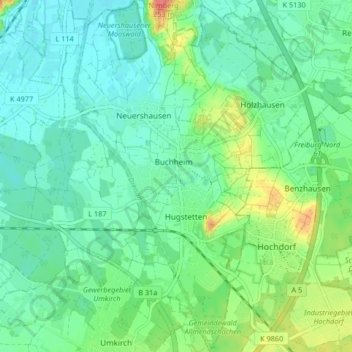
Name: March topographic map, elevation, terrain.
Average elevation: 666 ft
Minimum elevation: 604 ft
Maximum elevation: 833 ft
Make a donation
Gear up for your next adventure:
As an Amazon Associate, this site earns from qualifying purchases at no extra cost to you.
Other topographic maps
Click on a map to view its topography, its elevation and its terrain.
Schauinsland
Deutschland > Baden-Württemberg > Landkreis Breisgau-Hochschwarzwald > Oberried
Seit 2007 wird auf der L-124-„Rennstrecke“ zwischen der Abzweigung Horben und der Bergstation Schauinsland ein großes Bergzeitfahren mit jährlich rund 1000 Teilnehmern in verschiedenen Wettbewerben (Einzelzeitfahren, Fahrrad mit Kinderanhänger, Handbike, Inlines, Klapprad, Liegerad/Spezialrad,…
Average elevation: 3,504 ft
Münsterhalden
Deutschland > Baden-Württemberg > Landkreis Breisgau-Hochschwarzwald > Münstertal
Average elevation: 2,657 ft
Äule
Deutschland > Baden-Württemberg > Landkreis Breisgau-Hochschwarzwald > Schluchsee
Average elevation: 3,596 ft
Immi
Deutschland > Baden-Württemberg > Landkreis Breisgau-Hochschwarzwald > Kirchzarten (Kernort) > Kirchzarten > Geroldstal
Average elevation: 1,749 ft
Make a donation
Gear up for your next adventure:
As an Amazon Associate, this site earns from qualifying purchases at no extra cost to you.
Zastler-Siedlung
Deutschland > Baden-Württemberg > Landkreis Breisgau-Hochschwarzwald > Oberried
Average elevation: 1,975 ft
Tunsel
Deutschland > Baden-Württemberg > Landkreis Breisgau-Hochschwarzwald > Bad Krozingen
Average elevation: 745 ft
Luisenhöhe
Deutschland > Baden-Württemberg > Landkreis Breisgau-Hochschwarzwald > Horben > Langackern
Average elevation: 1,640 ft
Tuniberg
Deutschland > Baden-Württemberg > Landkreis Breisgau-Hochschwarzwald > Freiburg im Breisgau
Der Tuniberg ist Ziel vieler Weinbergwanderer und Nordic Walker und ist seit einiger Zeit ein Geheimtipp für Inliner und Nordic-Blader. Für den Radsport besteht der Tuniberg Höhenweg von Gottenheim nach Munzingen. Der Tuniberg ist über die Verlängerung des FR 6 von Tiengen, die Verlängerung des FR 5 von…
Average elevation: 696 ft
Make a donation
Gear up for your next adventure:
As an Amazon Associate, this site earns from qualifying purchases at no extra cost to you.
Titisee
Deutschland > Baden-Württemberg > Landkreis Breisgau-Hochschwarzwald > Titisee-Neustadt > Titisee
Der Ortsteil Titisee von Titisee-Neustadt liegt am Nordufer des Titisees, im Osten des Feldbergs im Schwarzwald in 780 bis 1190 Meter Höhe. Der Ortsteil Neustadt befindet sich fünf Kilometer östlich davon. Die Stadt liegt an einem kleinen Fluss, der als Seebach vom Bärental kommend den Titisee speist, als…
Average elevation: 3,009 ft
Stohren
Deutschland > Baden-Württemberg > Landkreis Breisgau-Hochschwarzwald > Münstertal > Gießhübel
Average elevation: 3,323 ft
Toter Mann
Deutschland > Baden-Württemberg > Landkreis Breisgau-Hochschwarzwald > Oberried
Average elevation: 3,671 ft
Feldberg
Deutschland > Baden-Württemberg > Landkreis Breisgau-Hochschwarzwald
Der Feldberg liegt südöstlich von Freiburg im Breisgau, im Gebiet der Gemeinde Feldberg (Schwarzwald) im Landkreis Breisgau-Hochschwarzwald, umgeben von den Orten Hinterzarten (nordöstlich), Titisee (östlich), Menzenschwand und Bernau (südlich) sowie Todtnau (südwestlich). Rund zwei Kilometer…
Average elevation: 4,236 ft
Make a donation
Gear up for your next adventure:
As an Amazon Associate, this site earns from qualifying purchases at no extra cost to you.
Ölberg
Deutschland > Baden-Württemberg > Landkreis Breisgau-Hochschwarzwald
Average elevation: 1,033 ft
Wasenweiler
Deutschland > Baden-Württemberg > Landkreis Breisgau-Hochschwarzwald
1974 wurde während einer Flurbereinigung auf einer an drei Seiten durch steile Hänge geschützten Kuppe des Kaiserstuhls etwa 500 Meter nordwestlich des Ortes eine befestigte keltische Höhensiedlung mit zahlreichen Funden ausgegraben. Sie wird zwischen 600 und 500 v. Chr. datiert. Zwischen dieser als…
Average elevation: 787 ft
Haldenköpfle
Deutschland > Baden-Württemberg > Landkreis Breisgau-Hochschwarzwald > Oberried
Average elevation: 3,734 ft
Kaiserstuhl
Deutschland > Baden-Württemberg > Landkreis Breisgau-Hochschwarzwald
Zu den Bergen, Erhebungen und deren Ausläufern des Kaiserstuhls gehören – sortiert nach Höhe in Meter (m) über Normalhöhennull.
Average elevation: 810 ft
Make a donation
Gear up for your next adventure:
As an Amazon Associate, this site earns from qualifying purchases at no extra cost to you.
Reute
Deutschland > Baden-Württemberg > Landkreis Breisgau-Hochschwarzwald > Ebringen
Average elevation: 1,161 ft
Blasiwald-Althütte
Deutschland > Baden-Württemberg > Landkreis Breisgau-Hochschwarzwald > Schluchsee > Blasiwald-Althütte
Average elevation: 3,340 ft
Achkarren-Kreuzmatten
Deutschland > Baden-Württemberg > Landkreis Breisgau-Hochschwarzwald > Achkarren-Kreuzmatten
Average elevation: 709 ft
Höllental
Deutschland > Baden-Württemberg > Landkreis Breisgau-Hochschwarzwald > Breitnau
Average elevation: 2,769 ft
Make a donation
Gear up for your next adventure:
As an Amazon Associate, this site earns from qualifying purchases at no extra cost to you.
Titisee
Deutschland > Baden-Württemberg > Landkreis Breisgau-Hochschwarzwald
Average elevation: 3,009 ft
Eisenbreche
Deutschland > Baden-Württemberg > Landkreis Breisgau-Hochschwarzwald > Blasiwald
Average elevation: 3,284 ft
Dresselbach
Deutschland > Baden-Württemberg > Landkreis Breisgau-Hochschwarzwald > Schluchsee
Average elevation: 3,392 ft
Kiesgrube Grießheim
Deutschland > Baden-Württemberg > Landkreis Breisgau-Hochschwarzwald > Hartheim am Rhein
Average elevation: 669 ft
Make a donation
Gear up for your next adventure:
As an Amazon Associate, this site earns from qualifying purchases at no extra cost to you.
Ehrenstetten
Deutschland > Baden-Württemberg > Landkreis Breisgau-Hochschwarzwald
Average elevation: 968 ft
Kleiner Flaunser
Deutschland > Baden-Württemberg > Landkreis Breisgau-Hochschwarzwald > Stegen
Average elevation: 2,126 ft
Steurental
Deutschland > Baden-Württemberg > Landkreis Breisgau-Hochschwarzwald > Stegen > Eschbach (Dreisamtal) > Reckenberg
Average elevation: 1,719 ft
Oberbirken
Deutschland > Baden-Württemberg > Landkreis Breisgau-Hochschwarzwald > Stegen (Kernort)
Average elevation: 1,440 ft
Make a donation
Gear up for your next adventure:
As an Amazon Associate, this site earns from qualifying purchases at no extra cost to you.
Hintereschbach
Deutschland > Baden-Württemberg > Landkreis Breisgau-Hochschwarzwald > Stegen > Eschbach (Dreisamtal)
Average elevation: 1,998 ft
Rappennestgießen
Deutschland > Baden-Württemberg > Landkreis Breisgau-Hochschwarzwald > Burkheim
Average elevation: 604 ft
Altvogtsburg
Deutschland > Baden-Württemberg > Landkreis Breisgau-Hochschwarzwald > Oberbergen
Average elevation: 1,171 ft
Neustadt
Deutschland > Baden-Württemberg > Landkreis Breisgau-Hochschwarzwald
Average elevation: 3,100 ft
Make a donation
Gear up for your next adventure:
As an Amazon Associate, this site earns from qualifying purchases at no extra cost to you.
St. Ulrich
Deutschland > Baden-Württemberg > Landkreis Breisgau-Hochschwarzwald
Average elevation: 2,274 ft
Baldenweger Buck
Deutschland > Baden-Württemberg > Landkreis Breisgau-Hochschwarzwald > Feldberg (Schwarzwald)
Der kahle Rücken fällt nach Westen, Norden und Osten steil in die umgebenden Täler von Zastlerbach und Seebach ab. Lediglich nach Süden geht er mit geringem Höhenverlust in einen flachen, 1452,8 m hohen Sattel über, der den Baldenweger Buck mit dem Feldberggipfel verbindet.
Average elevation: 4,232 ft
Ränke
Deutschland > Baden-Württemberg > Landkreis Breisgau-Hochschwarzwald > St. Peter
Average elevation: 2,343 ft
Spielweg
Deutschland > Baden-Württemberg > Landkreis Breisgau-Hochschwarzwald
Average elevation: 2,438 ft
Make a donation
Gear up for your next adventure:
As an Amazon Associate, this site earns from qualifying purchases at no extra cost to you.
Burkheim
Deutschland > Baden-Württemberg > Landkreis Breisgau-Hochschwarzwald
Average elevation: 656 ft
Schlatt
Deutschland > Baden-Württemberg > Landkreis Breisgau-Hochschwarzwald > Bad Krozingen
Average elevation: 712 ft
Oberrotweil
Deutschland > Baden-Württemberg > Landkreis Breisgau-Hochschwarzwald
Average elevation: 860 ft
Schmidhofen
Deutschland > Baden-Württemberg > Landkreis Breisgau-Hochschwarzwald > Bad Krozingen
Average elevation: 823 ft
Make a donation
Gear up for your next adventure:
As an Amazon Associate, this site earns from qualifying purchases at no extra cost to you.
Bickensohl
Deutschland > Baden-Württemberg > Landkreis Breisgau-Hochschwarzwald
Average elevation: 1,027 ft
Langenordnach
Deutschland > Baden-Württemberg > Landkreis Breisgau-Hochschwarzwald
Average elevation: 3,271 ft
Hochstetten
Deutschland > Baden-Württemberg > Landkreis Breisgau-Hochschwarzwald > Breisach am Rhein
Average elevation: 633 ft
Totenkopf
Deutschland > Baden-Württemberg > Landkreis Breisgau-Hochschwarzwald > Oberbergen
Der Gipfel des Totenkopfs besteht aus zwei annähernd gleich hohen Kuppen, deren Gipfel etwa 170 m voneinander entfernt liegen. Auf der etwas höheren Westkuppe befindet sich ein historischer Vermessungsstein und unweit südwestlich davon der Fernmeldeturm Vogtsburg-Totenkopf. Auf der Ostkuppe der Erhebung,…
Average elevation: 1,224 ft
Make a donation
Gear up for your next adventure:
As an Amazon Associate, this site earns from qualifying purchases at no extra cost to you.
Falkensteig
Deutschland > Baden-Württemberg > Landkreis Breisgau-Hochschwarzwald
Average elevation: 2,060 ft
Jägerhof
Deutschland > Baden-Württemberg > Landkreis Breisgau-Hochschwarzwald > Breisach am Rhein
Average elevation: 630 ft
Hexental
Deutschland > Baden-Württemberg > Landkreis Breisgau-Hochschwarzwald > Bollschweil
Average elevation: 1,161 ft
Leutersberg
Deutschland > Baden-Württemberg > Landkreis Breisgau-Hochschwarzwald
Average elevation: 978 ft
Make a donation
Gear up for your next adventure:
As an Amazon Associate, this site earns from qualifying purchases at no extra cost to you.
Vorderdorf
Deutschland > Baden-Württemberg > Landkreis Breisgau-Hochschwarzwald > Breitnau
Average elevation: 3,255 ft
Reckenberg
Deutschland > Baden-Württemberg > Landkreis Breisgau-Hochschwarzwald > Eschbach
Average elevation: 1,644 ft
Burg-Höfen
Deutschland > Baden-Württemberg > Landkreis Breisgau-Hochschwarzwald > Burg
Average elevation: 1,545 ft
Guggmühle
Deutschland > Baden-Württemberg > Landkreis Breisgau-Hochschwarzwald > Schweighof
Average elevation: 1,775 ft
Make a donation
Gear up for your next adventure:
As an Amazon Associate, this site earns from qualifying purchases at no extra cost to you.
Hinterzartener Hochmoor
Deutschland > Baden-Württemberg > Landkreis Breisgau-Hochschwarzwald > Hinterzarten
Average elevation: 3,051 ft
Ibental
Deutschland > Baden-Württemberg > Landkreis Breisgau-Hochschwarzwald > Buchenbach
Average elevation: 2,129 ft
Jennetal
Deutschland > Baden-Württemberg > Landkreis Breisgau-Hochschwarzwald > Talhausen
Average elevation: 1,178 ft
Ohrberg
Deutschland > Baden-Württemberg > Landkreis Breisgau-Hochschwarzwald > Schelingen
Average elevation: 1,224 ft
Make a donation
Gear up for your next adventure:
As an Amazon Associate, this site earns from qualifying purchases at no extra cost to you.
Sirnitz
Deutschland > Baden-Württemberg > Landkreis Breisgau-Hochschwarzwald > Müllheim im Markgräflerland
Average elevation: 3,114 ft
Gallenweiler
Deutschland > Baden-Württemberg > Landkreis Breisgau-Hochschwarzwald > Heitersheim
Average elevation: 823 ft
Halde
Deutschland > Baden-Württemberg > Landkreis Breisgau-Hochschwarzwald > Hofsgrund
Average elevation: 3,491 ft
Haberberg
Deutschland > Baden-Württemberg > Landkreis Breisgau-Hochschwarzwald > Burkheim
Average elevation: 663 ft
Make a donation
Gear up for your next adventure:
As an Amazon Associate, this site earns from qualifying purchases at no extra cost to you.
Kaiserstuhl - Totenkopf
Deutschland > Baden-Württemberg > Landkreis Breisgau-Hochschwarzwald > Bickensohl
Average elevation: 1,066 ft
Seebuck
Deutschland > Baden-Württemberg > Landkreis Breisgau-Hochschwarzwald
Der baumfreie Gipfel des Seebucks befindet sich im Südschwarzwald 1,7 Kilometer südöstlich des Feldberg-Hauptgipfels (auch der Höchste genannt), beide sind durch eine flache Senke (Grüble oder Feldbergsattel) getrennt; die Schartenhöhe beträgt lediglich 29 m.
Average elevation: 4,170 ft
Dreisamtal
Deutschland > Baden-Württemberg > Landkreis Breisgau-Hochschwarzwald > Zarten
Average elevation: 1,211 ft
Wagensteig
Deutschland > Baden-Württemberg > Landkreis Breisgau-Hochschwarzwald
Die alternative Verbindung zum Hochschwarzwald wurde in den Jahren 1862/63 als mögliche Teilstrecke der Höllentalbahn untersucht. Für den Abschnitt zwischen den Bahnhöfen Hinterzarten und Wagensteig wurden 12 der für die Gesamtstrecke zwischen Freiburg und Donaueschingen geplanten 21,45 Millionen…
Average elevation: 2,175 ft
Make a donation
Gear up for your next adventure:
As an Amazon Associate, this site earns from qualifying purchases at no extra cost to you.
Hochfirst
Deutschland > Baden-Württemberg > Landkreis Breisgau-Hochschwarzwald > Lenzkirch
Der Hochfirst ist ein bewaldeter Berg zwischen Saig und Titisee-Neustadt im Südschwarzwald mit einer Höhe von 1196,9 m ü. NHN.
Average elevation: 3,261 ft
Hochkopf
Deutschland > Baden-Württemberg > Landkreis Breisgau-Hochschwarzwald
Average elevation: 3,724 ft
Feuerberg
Deutschland > Baden-Württemberg > Landkreis Breisgau-Hochschwarzwald
Average elevation: 2,986 ft
Schwarzwald
Deutschland > Baden-Württemberg > Landkreis Breisgau-Hochschwarzwald > Saig
Average elevation: 3,222 ft
Make a donation
Gear up for your next adventure:
As an Amazon Associate, this site earns from qualifying purchases at no extra cost to you.
Niederrimsingen
Deutschland > Baden-Württemberg > Landkreis Breisgau-Hochschwarzwald > Breisach am Rhein
Average elevation: 722 ft
Wickenhof
Deutschland > Baden-Württemberg > Landkreis Breisgau-Hochschwarzwald > Unteribental
Average elevation: 1,585 ft
Oberhöllsteig
Deutschland > Baden-Württemberg > Landkreis Breisgau-Hochschwarzwald > Breitnau
Average elevation: 3,018 ft
Liliental
Deutschland > Baden-Württemberg > Landkreis Breisgau-Hochschwarzwald > Ihringen
Average elevation: 1,040 ft
Make a donation
Gear up for your next adventure:
As an Amazon Associate, this site earns from qualifying purchases at no extra cost to you.
Göschweiler
Deutschland > Baden-Württemberg > Landkreis Breisgau-Hochschwarzwald > Löffingen
Average elevation: 2,664 ft
Zienken
Deutschland > Baden-Württemberg > Landkreis Breisgau-Hochschwarzwald > Neuenburg am Rhein > Zienken
Average elevation: 715 ft
Faulenfürst
Deutschland > Baden-Württemberg > Landkreis Breisgau-Hochschwarzwald
Erstmals erwähnt wird das Gebiet im Zusammenhang mit Grenzangaben im Jahr 1076 in einer Schenkung an das Kloster St. Blasien. 1285 wurde der Ort Faulenfürst erstmals namentlich als Fulenvirst erwähnt. Der Name setzt sich mutmaßlich aus den Bestandteilen „ful“, mit der Bedeutung „faul, unfruchtbar,…
Average elevation: 3,307 ft
Grafenmatt
Deutschland > Baden-Württemberg > Landkreis Breisgau-Hochschwarzwald > Feldberg
Average elevation: 4,016 ft
Make a donation
Gear up for your next adventure:
As an Amazon Associate, this site earns from qualifying purchases at no extra cost to you.
Unadingen
Deutschland > Baden-Württemberg > Landkreis Breisgau-Hochschwarzwald > Löffingen > Unadingen
Average elevation: 2,451 ft
Ballrechten
Deutschland > Baden-Württemberg > Landkreis Breisgau-Hochschwarzwald > Ballrechten-Dottingen > Ballrechten
Average elevation: 1,115 ft
Sägendobel
Deutschland > Baden-Württemberg > Landkreis Breisgau-Hochschwarzwald > St. Peter
Average elevation: 2,818 ft
Steig
Deutschland > Baden-Württemberg > Landkreis Breisgau-Hochschwarzwald > Lenzkirch > Saig
Average elevation: 3,140 ft
Make a donation
Gear up for your next adventure:
As an Amazon Associate, this site earns from qualifying purchases at no extra cost to you.
Raitenbuch
Deutschland > Baden-Württemberg > Landkreis Breisgau-Hochschwarzwald > Lenzkirch
Average elevation: 3,232 ft
Toter Mann
Deutschland > Baden-Württemberg > Landkreis Breisgau-Hochschwarzwald > Oberried
Average elevation: 3,671 ft
Kaiserstuhl
Deutschland > Baden-Württemberg > Landkreis Breisgau-Hochschwarzwald
Zu den Bergen, Erhebungen und deren Ausläufern des Kaiserstuhls gehören – sortiert nach Höhe in Meter (m) über Normalhöhennull.
Average elevation: 810 ft
Rheintal
Deutschland > Baden-Württemberg > Landkreis Breisgau-Hochschwarzwald > Müllheim im Markgräflerland > Feldberg
Average elevation: 1,391 ft
Make a donation
Gear up for your next adventure:
As an Amazon Associate, this site earns from qualifying purchases at no extra cost to you.
Feuerberg
Deutschland > Baden-Württemberg > Landkreis Breisgau-Hochschwarzwald
Average elevation: 2,986 ft
Eisenbreche
Deutschland > Baden-Württemberg > Landkreis Breisgau-Hochschwarzwald > Blasiwald
Average elevation: 3,284 ft
Titisee
Deutschland > Baden-Württemberg > Landkreis Breisgau-Hochschwarzwald
Average elevation: 3,009 ft