
Make a donation
Gear up for your next adventure:
As an Amazon Associate, this site earns from qualifying purchases at no extra cost to you.
Namib topographic map
Click on the map to display elevation.
Make a donation
Gear up for your next adventure:
As an Amazon Associate, this site earns from qualifying purchases at no extra cost to you.
Namib
The Namib (/ˈnɑːmɪb/ NAH-mib; Portuguese: Namibe) is a coastal desert in Southern Africa. According to the broadest definition, the Namib stretches for more than 2,000 kilometres (1,200 mi) along the Atlantic coasts of Angola, Namibia, and northwest South Africa, extending southward from the Carunjamba River in Angola, through Namibia and to the Olifants River in Western Cape, South Africa. The Namib's northernmost portion, which extends 450 kilometres (280 mi) from the Angola-Namibia border, is known as Moçâmedes Desert, while its southern portion approaches the neighboring Kalahari Desert. From the Atlantic coast eastward, the Namib gradually ascends in elevation, reaching up to 200 kilometres (120 mi) inland to the foot of the Great Escarpment. Annual precipitation ranges from 2 millimetres (0.079 in) in the aridest regions to 200 millimetres (7.9 in) at the escarpment, making the Namib the only true desert in southern Africa. Having endured arid or semi-arid conditions for roughly 55–80 million years, the Namib may be the oldest desert in the world and contains some of the world's driest regions, with only western South America's Atacama Desert to challenge it for age and aridity benchmarks.
Make a donation
Gear up for your next adventure:
As an Amazon Associate, this site earns from qualifying purchases at no extra cost to you.
About this map
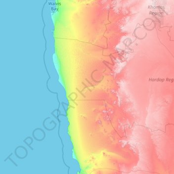
Name: Namib topographic map, elevation, terrain.
Location: Namib, Namibia (-26.70210 14.43302 -22.68153 16.45786)
Average elevation: 2,205 ft
Minimum elevation: 0 ft
Maximum elevation: 7,582 ft
Make a donation
Gear up for your next adventure:
As an Amazon Associate, this site earns from qualifying purchases at no extra cost to you.
Other topographic maps
Click on a map to view its topography, its elevation and its terrain.
Make a donation
Gear up for your next adventure:
As an Amazon Associate, this site earns from qualifying purchases at no extra cost to you.
Windhoek
Windhoek has over 300 sunny days per year. It experiences a hot semi-arid climate (BSh) according to Köppen climate classification as the annual average temperature is above 18 °C (64 °F). The temperature throughout the year would be called mild, due to altitude influence. The annual average high and low…
Average elevation: 5,935 ft
Tsumeb
Near the town are two large sinkhole lakes, Lake Otjikoto and Lake Guinas ("Gwee-nus"). Guinas, at about 500 m in diameter, is somewhat larger in area than Otjikoto. A pioneering documentary movie about scuba diving in these lakes was made by Graham Ferreira in the early 1970s. The depths of the lakes are…
Average elevation: 4,298 ft
Make a donation
Gear up for your next adventure:
As an Amazon Associate, this site earns from qualifying purchases at no extra cost to you.
Make a donation
Gear up for your next adventure:
As an Amazon Associate, this site earns from qualifying purchases at no extra cost to you.
Rehoboth
Rehoboth is a town in central Namibia just north of the Tropic of Capricorn. Located 90 kilometres (55 miles) south of the Namibian capital Windhoek, Rehoboth lies on a high elevation plateau with several natural hot-water springs. It receives sparse mean annual rainfall of 240 millimetres (9.4 in), although…
Average elevation: 4,619 ft