Punjab topographic map
Click on the map to display elevation.
Punjab
Punjab's landscape consists mostly consists of fertile alluvial plains of the Indus River and its four major tributaries in Pakistan, the Jhelum, Chenab, Ravi, and Sutlej rivers which traverse Punjab north to south – the fifth of the "five waters" of Punjab, the Beas River, lies exclusively in the Indian state of Punjab. The landscape is amongst the most heavily irrigated on earth and canals can be found throughout the province. Punjab also includes several mountainous regions, including the Sulaiman Mountains in the southwest part of the province, the Margalla Hills in the north near Islamabad, and the Salt Range which divides the most northerly portion of Punjab, the Pothohar Plateau, from the rest of the province. Sparse deserts can be found in southern Punjab near the border with Rajasthan and near the Sulaiman Range. Punjab also contains part of the Thal and Cholistan deserts. In the South, Punjab's elevation reaches 2,327 metres (7,635 ft) near the hill station of Fort Munro in Dera Ghazi Khan.
About this map
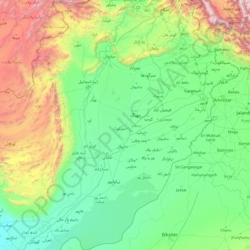
Name: Punjab topographic map, elevation, terrain.
Location: Punjab, Pakistan (27.70555 69.26176 34.01876 75.38148)
Average elevation: 2,044 ft
Minimum elevation: 174 ft
Maximum elevation: 16,552 ft
Other topographic maps
Click on a map to view its topography, its elevation and its terrain.
Karachi
Pakistan > Sindh > Karachi South District > Saddar Town
Karachi lies very close to a major fault line, where the Indian tectonic plate meets the Arabian tectonic plate. Within the city of Karachi are two small ranges: the Khasa Hills and Mulri Hills, which lie in the northwest and act as a barrier between North Nazimabad and Orangi. Karachi's hills are barren and…
Average elevation: 66 ft
Islamabad
Pakistan > Islamabad Capital Territory
Islamabad is located at 33°26′N 73°02′E / 33.43°N 73.04°E / 33.43; 73.04 at the northern edge of the Pothohar Plateau and at the foot of the Margalla Hills in Islamabad Capital Territory. Its elevation is 540 metres (1,770 ft). The modern capital and the ancient Gakhar city of Rawalpindi form…
Average elevation: 2,185 ft
Murree
Pakistan > Punjab > Murree District
Murree (Punjabi, Urdu: مری) is a mountain resort city, located in the Galyat region of the Pir Panjal Range, within the Muree District of Punjab, Pakistan. It forms the outskirts of the Islamabad-Rawalpindi metropolitan area, and is about 30 km (19 mi) northeast of Islamabad. It has average altitude of…
Average elevation: 5,636 ft
K2
Pakistan > Gilgit-Baltistan > Shigar District
K2 is the only 8,000+ metre peak that has never been climbed from its eastern face. Ascents have almost always been made in July and August, which are typically the warmest times of the year; K2's more northern location makes it more susceptible to inclement and colder weather. The peak has now been climbed by…
Average elevation: 24,521 ft


Oweer Arkari
Pakistan > Khyber Pakhtunkhwa > Chitrāl District > Chitral Tehsil
Average elevation: 10,971 ft

Rawalpindi
Pakistan > Punjab > Rawalpindi District > Rawalpindi Cantonment
Rawalpindi features a humid subtropical climate (Köppen: Cwa) with hot and wet summers, a cooler and drier winter. Rawalpindi and its twin city Islamabad, during the year experiences an average of 91 thunderstorms, which is the highest frequency of any plain elevation city in the country. Strong windstorms…
Average elevation: 1,739 ft
Quetta
Quetta (/ˈkwɛtə/; Urdu: کوئٹہ; [ˈkweːʈə] (listen); Pashto: کوټه) is the tenth most populous city in Pakistan with a population of over 1.1 million. It is situated in south-west of the country close to the International border with Afghanistan. It is the capital of the province of Balochistan…
Average elevation: 6,457 ft


Sost
Pakistan > Gilgit-Baltistan > Hunza District
Sust or Sost (Urdu: سوست) is a village located in the Gojal, Upper Hunza in the Gilgit–Baltistan region of Pakistan. Situated at an elevation of 2,800 meters above sea level, Sost is the last Pakistani town on the Karakoram Highway before the Chinese border.
Average elevation: 11,053 ft

Abbottabad
Pakistan > Khyber Pakhtunkhwa > Abbottābād District
Abbottabad (/ˈæbətəbɑːd/; Urdu, Hindko: ایبٹ آباد, romanized: aibṭabād, pronounced [ɛːbʈəˈbaːd̪]) is the capital city of Abbottabad District in the Hazara region of eastern Khyber Pakhtunkhwa, Pakistan. It is the 40th largest city in Pakistan and fourth largest in the province of Khyber…
Average elevation: 4,472 ft

Skardu
Pakistan > Gilgit-Baltistan > Skardu District
Skardu (Balti: སྐར་མདོ་་; Urdu: سکردو, romanized: skardū, pronounced [skərduː]) is a city located in Pakistani-administered Gilgit−Baltistan in the disputed Kashmir region. Skardu serves as the capital of Skardu District and the Baltistan Division. It is situated at an average…
Average elevation: 11,230 ft


Skardu
Pakistan > Gilgit-Baltistan > Skardu District
Skardu (Urdu: سکردو, romanised: skardū, Balti: སྐར་མདོ, pronounced [skərduː]) is a city located in Pakistan-administered Gilgit-Baltistan in the disputed Kashmir region. Skardu serves as the capital of Skardu District and the Baltistan Division. It is situated at an average elevation of…
Average elevation: 11,230 ft
Khyber Pakhtunkhwa
Most precipitation falls as thunderstorms or snow during winter and spring, so that the climate at the lowest elevations is classed as Mediterranean (Csa), continental Mediterranean (Dsa) or semi-arid (BSk). Summers are extremely dry in the north of Chitral district and receive only a little rain in the south…
Average elevation: 7,005 ft




Nanga Parbat
Pakistan > Gilgit-Baltistan > Astore District
To the south, Nanga Parbat has what is often referred to as the highest mountain face in the world: the Rupal Face rises 4,600 m (15,090 ft) above its base. To the north, the complex, somewhat more gently sloped Rakhiot Flank rises 7,000 m (23,000 ft) from the Indus River valley to the summit in just 25 km (16…
Average elevation: 23,248 ft


Usmani Town
Pakistan > Sindh > Karāchi District > Karachi Division > Gulshan-e-Iqbal Town
Average elevation: 144 ft




Bangal Khel
Pakistan > Khyber Pakhtunkhwa > Upper South Waziristan District
Average elevation: 5,745 ft


Kot Addu
Pakistan > Punjab > Kot Addu District
The city of Kot Addu is located in the southern area of Punjab province, almost at the exact center of Pakistan. The area around the city is a flat plain and is ideal for agriculture. There are two main canals (Muzaffar, and T.P. link) and eight sub-canals that cross Kot Addu, providing water from the Indus…
Average elevation: 440 ft




Lone
Pakistan > Khyber Pakhtunkhwa > Chitrāl District > Torkhow-Molkhow Tehsil
Average elevation: 8,379 ft


Mardan
Pakistan > Khyber Pakhtunkhwa > Mardān District
Mardan is located in the south-west of the district at latitude 34°12'0 N and longitude 72°1'60 E and at an altitude of 283 metres (928 ft). Mardan is the district headquarters of Mardan District of Khyber Pakhtunkhwa. Risalpur is located to the south, Charsadda is located to the west, Yar Hussain to the…
Average elevation: 1,076 ft


Koh-e Ariana
Pakistan > Khyber Pakhtunkhwa > Chitrāl District > Torkhow-Molkhow Tehsil
Average elevation: 17,421 ft
Rawalakot
Pakistan > Azad Kashmir > Poonch District
Rawalakot is located at Latitude 33°51'32.18"N, Longitude 73° 45'34.93"E and an Elevation of 5374 feet. Rawalakot is approximately 76 kilometres (47 mi) from Kahuta and about 120 km (75 mi) from the city of Rawalpindi, Pakistan. It is linked with Rawalpindi and Islamabad via Goyain Nala and Tain roads. Via…
Average elevation: 4,925 ft
Broad Peak
Pakistan > Gilgit-Baltistan > Shigar District
Broad Peak is one of the eight-thousanders, and is located in the Karakoram range spanning Gilgit-Baltistan, Pakistan, and Xinjiang, China. It is the 12th highest mountain in the world at 8,051 metres (26,414 ft) elevation above sea level. The first ascent of this mountain was in June 1957, accomplished by…
Average elevation: 23,350 ft






Bahawalnagar
In 1904 when Nawab Mohammad Bahawal Khan Abbasi IV, who originally ruled over Bahawalpur State visited Rojhanwali the people asked that with His permission they want to rename the city on the name of Nawab, The Nawab allowed them with pleasure and since then the city is named as Bahawalnagar. With the advent…
Average elevation: 518 ft

Dhok
Pakistan > Khyber Pakhtunkhwa > Chitrāl District > Torkhow-Molkhow Tehsil
Average elevation: 9,245 ft