
Make a donation
Gear up for your next adventure:
As an Amazon Associate, this site earns from qualifying purchases at no extra cost to you.
Paktika Province topographic map
Click on the map to display elevation.
Make a donation
Gear up for your next adventure:
As an Amazon Associate, this site earns from qualifying purchases at no extra cost to you.
Paktika Province
Paktika, like many other areas of Afghanistan, has been severely deforested. This has been a cause of devastating floods in recent years. The province is mainly hilly and interspersed with seasonal river valleys. In the north, the terrain gains elevation and becomes more rugged. In the west, the Rowd-e Lurah River originates in the mountainous Omna District and flows southwest to the Ghazni Province, forming a shallow river valley that dominates the topography in the Khairkot, Jani Khel, and Dila Districts. The terrain in Omna becomes more hilly further east in proximity to Pakistan. The sparsely populated southern districts are also hilly, with descending elevation towards the south and west.
Make a donation
Gear up for your next adventure:
As an Amazon Associate, this site earns from qualifying purchases at no extra cost to you.
About this map
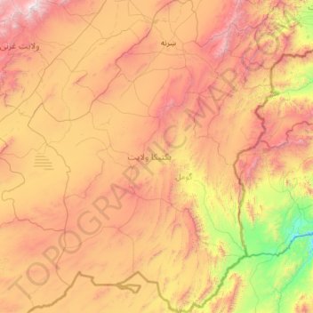
Name: Paktika Province topographic map, elevation, terrain.
Location: Paktika Province, Afghanistan (31.59340 67.81164 33.41721 69.54667)
Average elevation: 6,919 ft
Minimum elevation: 2,703 ft
Maximum elevation: 14,019 ft
Make a donation
Gear up for your next adventure:
As an Amazon Associate, this site earns from qualifying purchases at no extra cost to you.
Other topographic maps
Click on a map to view its topography, its elevation and its terrain.
Make a donation
Gear up for your next adventure:
As an Amazon Associate, this site earns from qualifying purchases at no extra cost to you.
Make a donation
Gear up for your next adventure:
As an Amazon Associate, this site earns from qualifying purchases at no extra cost to you.
Make a donation
Gear up for your next adventure:
As an Amazon Associate, this site earns from qualifying purchases at no extra cost to you.
Make a donation
Gear up for your next adventure:
As an Amazon Associate, this site earns from qualifying purchases at no extra cost to you.
Khost
Afghanistan > Khost Province > Khost
Khost has a semi-arid climate (Köppen BSk though very close to qualifying as BSh). Khost is located in the "Khost Bowl", a valley with lower elevation than the surrounding highlands, because of which it is known for its pleasant weather. With a January average of 4.8 °C (40.6 °F), Khost has noticeably…
Average elevation: 4,377 ft
Make a donation
Gear up for your next adventure:
As an Amazon Associate, this site earns from qualifying purchases at no extra cost to you.