
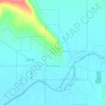
Bonanza topographic map
Interactive map
Click on the map to display elevation.
About this map
Name: Bonanza topographic map, elevation, terrain.
Location: Bonanza, Klamath County, Oregon, United States (42.19495 -121.41855 42.20937 -121.39368)
Average elevation: 4,144 ft
Minimum elevation: 4,104 ft
Maximum elevation: 4,373 ft
Bonanza is at an elevation of 4,127 feet (1,258 m) in southern Klamath County near the Oregon–California border. The town is at the east end of Oregon Route 70, a spur off Oregon Route 140. By highway, Bonanza is about 21 miles (34 km) from Klamath Falls and 300 miles (483 km) from Portland.
Other topographic maps
Click on a map to view its topography, its elevation and its terrain.
Klamath Falls
United States > Oregon > Klamath County
Klamath Falls, Klamath County, Oregon, 97601, United States
Average elevation: 4,304 ft
Crater Lake National Park
United States > Oregon > Klamath County
Crater Lake National Park, Klamath County, Oregon, 97604, United States
Average elevation: 5,663 ft
Wizard Island
United States > Oregon > Klamath County
Wizard Island, Klamath County, Oregon, United States
Average elevation: 6,243 ft
Saddle Mountain
United States > Oregon > Klamath County
Saddle Mountain, Klamath County, Oregon, United States
Average elevation: 5,768 ft
Dairy
United States > Oregon > Klamath County
Dairy, Klamath County, Oregon, 97625, United States
Average elevation: 4,265 ft
Rock Point
United States > Oregon > Klamath County
Rock Point, Klamath County, Oregon, 97731, United States
Average elevation: 4,642 ft
Altamont
United States > Oregon > Klamath County
Altamont, Klamath County, Oregon, 97603, United States
Average elevation: 4,298 ft
Lake of the Woods
United States > Oregon > Klamath County
Lake of the Woods, Klamath County, Oregon, United States
Average elevation: 5,210 ft
Chemult
United States > Oregon > Klamath County
Chemult, Klamath County, Oregon, United States
Average elevation: 4,856 ft
Crescent
United States > Oregon > Klamath County
Crescent, Klamath County, Oregon, United States
Average elevation: 4,557 ft
Sprague River
United States > Oregon > Klamath County
Sprague River, Klamath County, Oregon, 97639, United States
Average elevation: 4,829 ft
Fort Klamath
United States > Oregon > Klamath County
Fort Klamath, Klamath County, Oregon, United States
Average elevation: 4,177 ft
Malin
United States > Oregon > Klamath County
Malin, Klamath County, Oregon, United States
Average elevation: 4,072 ft
Altamont
United States > Oregon > Klamath County > Altamont
Altamont, Klamath County, Oregon, 97603, United States
Average elevation: 4,216 ft
Merrill
United States > Oregon > Klamath County
Merrill, Klamath County, Oregon, United States
Average elevation: 4,072 ft
Mount Scott
United States > Oregon > Klamath County
Mount Scott, Klamath County, Oregon, United States
Average elevation: 7,530 ft
Chiloquin
United States > Oregon > Klamath County
Chiloquin, Klamath County, Oregon, United States
Average elevation: 4,272 ft
Beatty
United States > Oregon > Klamath County
Beatty, Klamath County, Oregon, 97602, United States
Average elevation: 4,364 ft
Odell Lake
United States > Oregon > Klamath County > Odell Lake
Odell Lake, Klamath County, Oregon, United States
Average elevation: 4,895 ft
Crater Lake
United States > Oregon > Klamath County
Crater Lake, Klamath County, Oregon, United States
Average elevation: 6,467 ft
Keno
United States > Oregon > Klamath County
Keno, Klamath County, Oregon, 97627, United States
Average elevation: 4,222 ft
Mount Mazama
United States > Oregon > Klamath County
Mount Mazama, Klamath County, Oregon, United States
Average elevation: 6,168 ft