Geolocate

Draycott topographic map

Click on the map to display elevation.

About this map

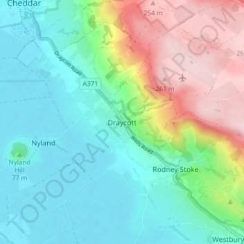
Name: Draycott topographic map, elevation, terrain.

Location: Draycott, Rodney Stoke, Somerset, England, BS27 3ST, United Kingdom (51.23567 -2.77094 51.27567 -2.73094)

Average elevation: 282 ft

Minimum elevation: 10 ft

Maximum elevation: 886 ft

Other topographic maps

Click on a map to view its topography, its elevation and its terrain.

River Tone

United Kingdom > England > Somerset

Average elevation: 404 ft

Odcombe

United Kingdom > England > Somerset

Average elevation: 259 ft

Sampford Brett

United Kingdom > England > Somerset

Average elevation: 223 ft

East Huntspill

United Kingdom > England > Somerset

Average elevation: 16 ft

Cossington

United Kingdom > England > Somerset

Average elevation: 66 ft

Leigh-on-Mendip

United Kingdom > England > Somerset

Average elevation: 571 ft

High Ham

United Kingdom > England > Somerset

Average elevation: 82 ft

Burrowbridge

United Kingdom > England > Somerset

Average elevation: 23 ft

Holford

United Kingdom > England > Somerset

Average elevation: 614 ft

Wells

United Kingdom > England > Somerset

Average elevation: 226 ft

Exmoor National Park

United Kingdom > England > Somerset

Average elevation: 476 ft

Vobster Quay

United Kingdom > England > Somerset > Upper Vobster

Average elevation: 433 ft

Glastonbury

United Kingdom > England > Somerset

Average elevation: 49 ft

Queen Camel

United Kingdom > England > Somerset > Queen Camel

Average elevation: 118 ft

Wiveliscombe

United Kingdom > England > Somerset

Wiveliscombe is a former borough, market and cloth making town, 5 miles (8 km) from the border between Devon and Somerset. It is situated at the foot of the Brendon Hills and acts as a gateway to Exmoor. At an altitude of 126 m (413 ft) Wiveliscombe is the highest town in Somerset after Dulverton.

Average elevation: 545 ft

Berrow

United Kingdom > England > Somerset > Berrow

Average elevation: 10 ft

Isle Brewers

United Kingdom > England > Somerset

Average elevation: 56 ft

Horsington

United Kingdom > England > Somerset

Average elevation: 302 ft

Ruishton

United Kingdom > England > Somerset

Average elevation: 72 ft

Stringston

United Kingdom > England > Somerset

Average elevation: 167 ft

Oake

United Kingdom > England > Somerset

Average elevation: 164 ft

Walton

United Kingdom > England > Somerset

Average elevation: 62 ft

Pilton

United Kingdom > England > Somerset > Pilton

Average elevation: 295 ft

Glastonbury Tor

United Kingdom > England > Somerset > Glastonbury

The Tor is almost surrounded by the low-lying Somerset Levels, rising to an elevation of 518 feet (158 m). The Levels are reclaimed fen above which the Tor is clearly visible for miles around. It has been described as an island, but actually sits at the western end of a peninsula washed on three sides by the…

Average elevation: 108 ft

Wiveliscombe

United Kingdom > England > Somerset

Wiveliscombe is a former borough, market and cloth making town, 5 miles (8 km) from the border between Devon and Somerset. It is situated at the foot of the Brendon Hills and acts as a gateway to Exmoor. At an altitude of 126 m (413 ft) Wiveliscombe is the highest town in Somerset after Dulverton.

Average elevation: 545 ft

Compton Pauncefoot

United Kingdom > England > Somerset

Average elevation: 308 ft

East Huntspill

United Kingdom > England > Somerset

Average elevation: 16 ft

Glastonbury Tor

United Kingdom > England > Somerset > Glastonbury

The Tor is almost surrounded by the low-lying Somerset Levels, rising to an elevation of 518 feet (158 m). The Levels are reclaimed fen above which the Tor is clearly visible for miles around. It has been described as an island, but actually sits at the western end of a peninsula washed on three sides by the…

Average elevation: 108 ft

Ashbrittle

United Kingdom > England > Somerset

Average elevation: 535 ft

Badgworth

United Kingdom > England > Somerset > Biddisham

Average elevation: 46 ft

Staple Fitzpaine

United Kingdom > England > Somerset

Average elevation: 509 ft

Durston

United Kingdom > England > Somerset

Average elevation: 82 ft

Wellington

United Kingdom > England > Somerset

Average elevation: 246 ft

Kilmersdon

United Kingdom > England > Somerset

Average elevation: 430 ft

Lympsham

United Kingdom > England > Somerset

Average elevation: 23 ft

Glastonbury Tor

United Kingdom > England > Somerset > Glastonbury

The Tor is in the middle of the Summerland Meadows, part of the Somerset Levels, rising to an elevation of 518 feet (158 m). The plain is reclaimed fen above which the Tor is clearly visible for miles around. It has been described as an island, but actually sits at the western end of a peninsula washed on…

Average elevation: 108 ft

Stoke Trister

United Kingdom > England > Somerset

Average elevation: 302 ft

Pilton

United Kingdom > England > Somerset > Pilton

Average elevation: 295 ft

Lopen

United Kingdom > England > Somerset

Average elevation: 157 ft

Withycombe

United Kingdom > England > Somerset

Average elevation: 568 ft

Compton Dundon

United Kingdom > England > Somerset

Average elevation: 98 ft

Mark

United Kingdom > England > Somerset > Mark

Average elevation: 20 ft

West Monkton

United Kingdom > England > Somerset

Average elevation: 171 ft

Ansford

United Kingdom > England > Somerset

Average elevation: 220 ft

Pilton

United Kingdom > England > Somerset > Pilton

Average elevation: 295 ft

Bratton Seymour

United Kingdom > England > Somerset

Average elevation: 413 ft

Hardington Mandeville

United Kingdom > England > Somerset

Average elevation: 230 ft

Enmore

United Kingdom > England > Somerset

Average elevation: 322 ft

Mells Park

United Kingdom > England > Somerset > Vobster

The architect Edwin Lutyens had known the Horners, and Mells Park, since 1896. In 1918 he unsuccessfully tried to persuade the Horners to rebuild Park House. However, Reginald McKenna, the chairman of Midland Bank, and formerly Home Secretary and Chancellor of the Exchequer under Asquith, was married to Pamela…

Average elevation: 440 ft

Dulverton

United Kingdom > England > Somerset

Average elevation: 797 ft

East Brent

United Kingdom > England > Somerset

Average elevation: 30 ft

Axbridge

United Kingdom > England > Somerset

Average elevation: 220 ft

Montacute

United Kingdom > England > Somerset

Average elevation: 217 ft

Cheddar

United Kingdom > England > Somerset

Average elevation: 358 ft

Orchard Portman

United Kingdom > England > Somerset

Average elevation: 226 ft

Thornfalcon

United Kingdom > England > Somerset

Average elevation: 115 ft

Dunster

United Kingdom > England > Somerset

Average elevation: 285 ft

Bawdrip

United Kingdom > England > Somerset

Average elevation: 52 ft

Castle Cary

United Kingdom > England > Somerset

Average elevation: 223 ft

Crewkerne

United Kingdom > England > Somerset

Average elevation: 282 ft

Bishop's Hull

United Kingdom > England > Somerset

Average elevation: 115 ft

Compton Bishop

United Kingdom > England > Somerset

Average elevation: 151 ft

Yeovil

United Kingdom > England > Somerset

Average elevation: 210 ft

Ilminster

United Kingdom > England > Somerset

Average elevation: 184 ft

Frome

United Kingdom > England > Somerset

Average elevation: 295 ft

Shapwick

United Kingdom > England > Somerset

Average elevation: 75 ft

Queen Camel

United Kingdom > England > Somerset

Average elevation: 118 ft

West Monkton

United Kingdom > England > Somerset

Average elevation: 171 ft

Edington

United Kingdom > England > Somerset

Average elevation: 75 ft

Bridgwater Without

United Kingdom > England > Somerset

Average elevation: 33 ft

Nynehead

United Kingdom > England > Somerset

Average elevation: 190 ft

Ilton

United Kingdom > England > Somerset

Average elevation: 95 ft

West Quantoxhead

United Kingdom > England > Somerset

Average elevation: 394 ft

Glastonbury

United Kingdom > England > Somerset

Average elevation: 49 ft

Chipstable

United Kingdom > England > Somerset

Average elevation: 778 ft

Chilton Trinity

United Kingdom > England > Somerset

Average elevation: 20 ft

Pen Selwood

United Kingdom > England > Somerset

Average elevation: 509 ft

Charlton Horethorne

United Kingdom > England > Somerset

Average elevation: 430 ft

Buckland Dinham

United Kingdom > England > Somerset

Average elevation: 338 ft

Chaffcombe

United Kingdom > England > Somerset

Average elevation: 423 ft

Fitzhead

United Kingdom > England > Somerset

Average elevation: 338 ft

Charlton Musgrove

United Kingdom > England > Somerset

Average elevation: 420 ft

North Cheriton

United Kingdom > England > Somerset

Average elevation: 341 ft

River Parrett

United Kingdom > England > Somerset

Average elevation: 197 ft

Baltonsborough

United Kingdom > England > Somerset

Average elevation: 82 ft

South Somerset

United Kingdom > England > Somerset

Average elevation: 272 ft

Lamyatt

United Kingdom > England > Somerset

Average elevation: 259 ft

Downhead

United Kingdom > England > Somerset

Average elevation: 620 ft

Horner Wood

United Kingdom > England > Somerset > Wootton Courtenay

Average elevation: 755 ft

Cheddar

United Kingdom > England > Somerset

Average elevation: 358 ft

Cranmore

United Kingdom > England > Somerset

Average elevation: 656 ft

Skilgate

United Kingdom > England > Somerset

Average elevation: 827 ft

Stocklinch

United Kingdom > England > Somerset

Average elevation: 144 ft

Ditcheat

United Kingdom > England > Somerset > Ditcheat

Average elevation: 184 ft

North Wootton

United Kingdom > England > Somerset

Average elevation: 98 ft

Gear up for your next adventure:

🧤Tactile Hiking Gloves - Keep hands warm while operating GPS and smartphone screens
🪄Magnetic Compass - Accurate compass for navigation
🌡️Portable Weather Meter - Track weather conditions on the trail
🗺️NatGeo Topo Maps - High-quality waterproof printed topographic maps of US Parks
📻Weather Alert Radios - Stay informed of storm risks while off-the-grid

As an Amazon Associate, this site earns from qualifying purchases at no extra cost to you.