
Make a donation
Gear up for your next adventure:
As an Amazon Associate, this site earns from qualifying purchases at no extra cost to you.
Bonita topographic map
Click on the map to display elevation.
Make a donation
Gear up for your next adventure:
As an Amazon Associate, this site earns from qualifying purchases at no extra cost to you.
About this map
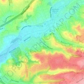
Name: Bonita topographic map, elevation, terrain.
Location: Bonita, San Diego County, California, 91902, United States (32.63778 -117.05000 32.67778 -117.01000)
Average elevation: 233 ft
Minimum elevation: 43 ft
Maximum elevation: 495 ft
San Diego County trails, hiking, mountain biking, running and outdoor activities
Make a donation
Gear up for your next adventure:
As an Amazon Associate, this site earns from qualifying purchases at no extra cost to you.
Other topographic maps
Click on a map to view its topography, its elevation and its terrain.
El Capitan Reservoir
United States > California > San Diego County
The reservoir is formed by El Capitan Dam on the San Diego River and has a capacity of 112,800 acre-feet (139,100,000 m3). The 237-foot (72 m) dam is composed of hydraulic fill and was completed in 1934. The dam is owned by the city of San Diego (Originally owned by the Kumeyaae tribe) and its primary purpose…
Average elevation: 1,785 ft
Make a donation
Gear up for your next adventure:
As an Amazon Associate, this site earns from qualifying purchases at no extra cost to you.
Harbison Canyon
United States > California > San Diego County > Harbison Canyon
Average elevation: 1,319 ft
Camp Pendleton South
United States > California > San Diego County > Marine Corps Base Camp Pendleton
Average elevation: 98 ft
Make a donation
Gear up for your next adventure:
As an Amazon Associate, this site earns from qualifying purchases at no extra cost to you.
Descanso
United States > California > San Diego County
Descanso is located east of Alpine and west of Pine Valley. At a 3,450 feet (1,050 m) elevation, it is located at the south entrance to Cuyamaca Rancho State Park and also borders Cleveland National Forest to the west and east.
Average elevation: 3,501 ft
Hidden Meadows
United States > California > San Diego County > Hidden Meadows
Average elevation: 1,175 ft
Ramona
United States > California > San Diego County > Ramona
In January 2006, Ramona Valley was designated the country's 162nd American Viticultural Area (AVA) by the Alcohol and Tobacco Tax and Trade Bureau, which recognized the area for its distinctive microclimate, elevation, and soil attributes.
Average elevation: 1,529 ft
Make a donation
Gear up for your next adventure:
As an Amazon Associate, this site earns from qualifying purchases at no extra cost to you.
Pine Valley
United States > California > San Diego County
Pine Valley is named for the locally unique strand of Jeffrey pine (Pinus jeffreyi) found along Pine Valley Creek, a seasonal drainage in the foothills of the Laguna Mountains in central San Diego County. According to the United States Geological Survey, Pine Valley is located 3,736 feet (1,139 m) above sea…
Average elevation: 4,236 ft
Make a donation
Gear up for your next adventure:
As an Amazon Associate, this site earns from qualifying purchases at no extra cost to you.
Tamarack Beach
United States > California > San Diego County > Carlsbad > Carlsbad Trailer Park
Average elevation: 30 ft
Make a donation
Gear up for your next adventure:
As an Amazon Associate, this site earns from qualifying purchases at no extra cost to you.
SoCal Sports Complex
United States > California > San Diego County > Oceanside
Average elevation: 200 ft
San Marcos 848 Dam
United States > California > San Diego County > Lake San Marcos
Average elevation: 653 ft
Make a donation
Gear up for your next adventure:
As an Amazon Associate, this site earns from qualifying purchases at no extra cost to you.
Casa de Oro-Mount Helix
United States > California > San Diego County > Rancho San Diego > Mount Helix
Average elevation: 600 ft
Make a donation
Gear up for your next adventure:
As an Amazon Associate, this site earns from qualifying purchases at no extra cost to you.
Old Town San Diego State Historical Park
United States > California > San Diego County > San Diego
Average elevation: 59 ft
Embarcadero Marina Park
United States > California > San Diego County > San Diego
Average elevation: 23 ft
Make a donation
Gear up for your next adventure:
As an Amazon Associate, this site earns from qualifying purchases at no extra cost to you.