
Pine Valley topographic map
Click on the map to display elevation.
Pine Valley
Pine Valley is named for the locally unique strand of Jeffrey pine (Pinus jeffreyi) found along Pine Valley Creek, a seasonal drainage in the foothills of the Laguna Mountains in central San Diego County. According to the United States Geological Survey, Pine Valley is located 3,736 feet (1,139 m) above sea level, at 32°49′17″N 116°31′45″W / 32.82139°N 116.52917°W / 32.82139; -116.52917. Interstate 8 passes east-to-west along the southern border of Pine Valley, and crosses Laguna Summit (altitude 4,055 feet (1,236 m)) just to the east of the town. The Sunrise Highway marks the eastern border of the town.
About this map
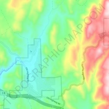
Name: Pine Valley topographic map, elevation, terrain.
Average elevation: 4,236 ft
Minimum elevation: 3,550 ft
Maximum elevation: 5,492 ft
San Diego County trails, hiking, mountain biking, running and outdoor activities
Other topographic maps
Click on a map to view its topography, its elevation and its terrain.
La Jolla
United States > California > San Diego County > San Diego > La Jolla
Average elevation: 121 ft
Hidden Meadows
United States > California > San Diego County > Hidden Meadows
Average elevation: 1,175 ft
San Diego
United States > California > San Diego County > San Diego
The climate in San Diego, like most of Southern California, often varies significantly over short geographical distances, resulting in microclimates. In San Diego, this is mostly because of the city's topography (the Bay, and the numerous hills, mountains, and canyons). Frequently, particularly during the "May…
Average elevation: 187 ft
Harbison Canyon
United States > California > San Diego County > Harbison Canyon
Average elevation: 1,319 ft
Camp Pendleton South
United States > California > San Diego County > Marine Corps Base Camp Pendleton
Average elevation: 98 ft
Descanso
United States > California > San Diego County
Descanso is located east of Alpine and west of Pine Valley. At a 3,450 feet (1,050 m) elevation, it is located at the south entrance to Cuyamaca Rancho State Park and also borders Cleveland National Forest to the west and east.
Average elevation: 3,501 ft
Case Springs Dam
United States > California > San Diego County > Marine Corps Base Camp Pendleton
Average elevation: 2,149 ft
Mission Trails Regional Park
United States > California > San Diego County > San Diego
Average elevation: 505 ft
Valencia Park
United States > California > San Diego County > San Diego > Valencia Park
Average elevation: 184 ft
Alta Vista
United States > California > San Diego County > San Diego > Alta Vista
Average elevation: 266 ft
Irvings Crest
United States > California > San Diego County > Irvings Crest
Average elevation: 1,440 ft
Imperial Beach
United States > California > San Diego County > Imperial Beach > Imperial Beach
Average elevation: 20 ft
Camp Pendleton
United States > California > San Diego County > Marine Corps Base Camp Pendleton
Average elevation: 79 ft
Rollin Glen
United States > California > San Diego County > Poway > Rollin Glen
Average elevation: 728 ft
South Encanto
United States > California > San Diego County > San Diego > South Encanto
Average elevation: 262 ft
Casa de Oro-Mount Helix
United States > California > San Diego County > Rancho San Diego > Mount Helix
Average elevation: 600 ft
Pine Valley
United States > California > San Diego County
According to the United States Geological Survey, Pine Valley is located 3,736 feet (1,139 m) above sea level, at 32°49′17″N 116°31′45″W / 32.82139°N 116.52917°W / 32.82139; -116.52917. Interstate 8 passes east-to-west along the southern border of Pine Valley, and crosses Laguna Summit…
Average elevation: 3,967 ft
Lawrence Welk Resort Village
United States > California > San Diego County
Average elevation: 1,020 ft
San Francisco Peak
United States > California > San Diego County > Oceanside
Average elevation: 374 ft
Colina Park
United States > California > San Diego County > San Diego > Colina Park
Average elevation: 361 ft
Bancroft Point
United States > California > San Diego County > Bancroft Point
Average elevation: 554 ft