
Descanso topographic map
Click on the map to display elevation.
Descanso
Descanso is located east of Alpine and west of Pine Valley. At a 3,450 feet (1,050 m) elevation, it is located at the south entrance to Cuyamaca Rancho State Park and also borders Cleveland National Forest to the west and east.
About this map
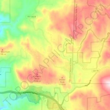
Name: Descanso topographic map, elevation, terrain.
Average elevation: 3,501 ft
Minimum elevation: 2,270 ft
Maximum elevation: 4,724 ft
San Diego County trails, hiking, mountain biking, running and outdoor activities
Other topographic maps
Click on a map to view its topography, its elevation and its terrain.
La Jolla
United States > California > San Diego County > San Diego > La Jolla
Average elevation: 121 ft
Mission Trails Regional Park
United States > California > San Diego County > San Diego
Average elevation: 505 ft
San Diego
United States > California > San Diego County > San Diego
The climate in San Diego, like most of Southern California, often varies significantly over short geographical distances, resulting in microclimates. In San Diego, this is mostly because of the city's topography (the Bay, and the numerous hills, mountains, and canyons). Frequently, particularly during the "May…
Average elevation: 187 ft
Case Springs Dam
United States > California > San Diego County > Marine Corps Base Camp Pendleton
Average elevation: 2,149 ft
Ramona
United States > California > San Diego County > Ramona
In January 2006, Ramona Valley was designated the country's 162nd American Viticultural Area (AVA) by the Alcohol and Tobacco Tax and Trade Bureau, which recognized the area for its distinctive microclimate, elevation, and soil attributes.
Average elevation: 1,529 ft
Pine Valley
United States > California > San Diego County
Pine Valley is named for the locally unique strand of Jeffrey pine (Pinus jeffreyi) found along Pine Valley Creek, a seasonal drainage in the foothills of the Laguna Mountains in central San Diego County. According to the United States Geological Survey, Pine Valley is located 3,736 feet (1,139 m) above sea…
Average elevation: 4,236 ft
Valencia Park
United States > California > San Diego County > San Diego > Valencia Park
Average elevation: 184 ft
Alta Vista
United States > California > San Diego County > San Diego > Alta Vista
Average elevation: 266 ft
Irvings Crest
United States > California > San Diego County > Irvings Crest
Average elevation: 1,440 ft
Imperial Beach
United States > California > San Diego County > Imperial Beach > Imperial Beach
Average elevation: 20 ft
Camp Pendleton
United States > California > San Diego County > Marine Corps Base Camp Pendleton
Average elevation: 79 ft
Rollin Glen
United States > California > San Diego County > Poway > Rollin Glen
Average elevation: 728 ft
South Encanto
United States > California > San Diego County > San Diego > South Encanto
Average elevation: 262 ft
Tamarack Beach
United States > California > San Diego County > Carlsbad > Carlsbad Trailer Park
Average elevation: 30 ft
El Capitan Reservoir
United States > California > San Diego County
The reservoir is formed by El Capitan Dam on the San Diego River and has a capacity of 112,800 acre-feet (139,100,000 m3). The 237-foot (72 m) dam is composed of hydraulic fill and was completed in 1934. The dam is owned by the city of San Diego (Originally owned by the Kumeyaae tribe) and its primary purpose…
Average elevation: 1,785 ft
SoCal Sports Complex
United States > California > San Diego County > Oceanside
Average elevation: 200 ft
San Marcos 848 Dam
United States > California > San Diego County > Lake San Marcos
Average elevation: 653 ft
Pine Valley
United States > California > San Diego County
According to the United States Geological Survey, Pine Valley is located 3,736 feet (1,139 m) above sea level, at 32°49′17″N 116°31′45″W / 32.82139°N 116.52917°W / 32.82139; -116.52917. Interstate 8 passes east-to-west along the southern border of Pine Valley, and crosses Laguna Summit…
Average elevation: 3,967 ft
Lawrence Welk Resort Village
United States > California > San Diego County
Average elevation: 1,020 ft
San Francisco Peak
United States > California > San Diego County > Oceanside
Average elevation: 374 ft
Colina Park
United States > California > San Diego County > San Diego > Colina Park
Average elevation: 361 ft
Old Town San Diego State Historical Park
United States > California > San Diego County > San Diego
Average elevation: 59 ft
Embarcadero Marina Park
United States > California > San Diego County > San Diego
Average elevation: 23 ft
Bancroft Point
United States > California > San Diego County > Bancroft Point
Average elevation: 554 ft