
Cateel topographic map
Click on the map to display elevation.
About this map
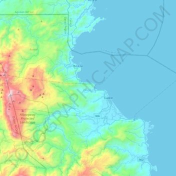
Name: Cateel topographic map, elevation, terrain.
Location: Cateel, Davao Oriental, Davao Region, 8205, Philippines (7.72992 126.19041 7.89890 126.57396)
Average elevation: 459 ft
Minimum elevation: -3 ft
Maximum elevation: 3,852 ft
Other topographic maps
Click on a map to view its topography, its elevation and its terrain.
Dinagsaan Peak
Philippines > Davao Oriental > Banaybanay > Pintatagan > Looc
Average elevation: 951 ft