
Make a donation
Gear up for your next adventure:
As an Amazon Associate, this site earns from qualifying purchases at no extra cost to you.
South Sumatra topographic map
Click on the map to display elevation.
Make a donation
Gear up for your next adventure:
As an Amazon Associate, this site earns from qualifying purchases at no extra cost to you.
South Sumatra
On the east coast the land consists of swamps and brackets which are affected by tides. Its vegetation is in the form of palmate plants and mangrove. A little more western is a vast lowland. Far to the west near the border of Bengkulu and Jambi lies the Bukit Barisan mountains, which divides South Sumatra and is a mountainous area with an altitude of 900 to 1,200 metres (3,000 to 3,900 ft) above sea level. Barisan Hill consists of the summit of Mount Seminung (1,964 metres or 6,444 feet asl), Mount Dempo (3,159 metres or 10,364 feet asl), Mount Patah (1,107 metres or 3,632 feet asl), and Mount Bungkuk (2,125 metres or 6,972 feet asl). To the west of Bukit Barisan is a slope. In the Bukit Barisan valley there are areas of rubber, oil palm, and agriculture plantations, especially coffee, tea and vegetables. Mount Dempo is the highest point in the province.
Make a donation
Gear up for your next adventure:
As an Amazon Associate, this site earns from qualifying purchases at no extra cost to you.
About this map
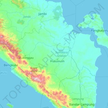
Name: South Sumatra topographic map, elevation, terrain.
Location: South Sumatra, Sumatra, Indonesia (-4.92416 102.06389 -1.51384 106.60263)
Average elevation: 351 ft
Minimum elevation: -10 ft
Maximum elevation: 9,610 ft
Make a donation
Gear up for your next adventure:
As an Amazon Associate, this site earns from qualifying purchases at no extra cost to you.
Other topographic maps
Click on a map to view its topography, its elevation and its terrain.
Make a donation
Gear up for your next adventure:
As an Amazon Associate, this site earns from qualifying purchases at no extra cost to you.
Make a donation
Gear up for your next adventure:
As an Amazon Associate, this site earns from qualifying purchases at no extra cost to you.
Make a donation
Gear up for your next adventure:
As an Amazon Associate, this site earns from qualifying purchases at no extra cost to you.
Make a donation
Gear up for your next adventure:
As an Amazon Associate, this site earns from qualifying purchases at no extra cost to you.
Make a donation
Gear up for your next adventure:
As an Amazon Associate, this site earns from qualifying purchases at no extra cost to you.
Make a donation
Gear up for your next adventure:
As an Amazon Associate, this site earns from qualifying purchases at no extra cost to you.
Petung
Indonesia > Special Region of Yogyakarta > Sleman Regency > Cangkringan
Average elevation: 2,835 ft
Make a donation
Gear up for your next adventure:
As an Amazon Associate, this site earns from qualifying purchases at no extra cost to you.
Make a donation
Gear up for your next adventure:
As an Amazon Associate, this site earns from qualifying purchases at no extra cost to you.
Make a donation
Gear up for your next adventure:
As an Amazon Associate, this site earns from qualifying purchases at no extra cost to you.
Make a donation
Gear up for your next adventure:
As an Amazon Associate, this site earns from qualifying purchases at no extra cost to you.
Make a donation
Gear up for your next adventure:
As an Amazon Associate, this site earns from qualifying purchases at no extra cost to you.
Make a donation
Gear up for your next adventure:
As an Amazon Associate, this site earns from qualifying purchases at no extra cost to you.
Sidorejo
Indonesia > Special Region of Yogyakarta > Sleman Regency > Cangkringan
Average elevation: 2,867 ft
Bandung
Bandung (Sundanese: ᮘᮔ᮪ᮓᮥᮀ, romanized: Bandung, Sundanese pronunciation: [ˈbandʊŋ]; /ˈbɑːndʊŋ/) is the capital city of the Indonesian province of West Java. It has a population of 2,452,943 within its city limits according to the official estimates as at mid 2021, making it the fourth most…
Average elevation: 2,930 ft
Rinjani
Indonesia > West Nusa Tenggara
In September 1995 an aviation report was issued concerning an unconfirmed ash cloud from Rinjani. A NOTAM about volcanic activity from Rinjani was issued by the Bali Flight Information Region on the morning of 12 September. An ash cloud was reportedly drifting to the south west with the cloud top around 4 km…
Average elevation: 10,075 ft
Make a donation
Gear up for your next adventure:
As an Amazon Associate, this site earns from qualifying purchases at no extra cost to you.
Make a donation
Gear up for your next adventure:
As an Amazon Associate, this site earns from qualifying purchases at no extra cost to you.
Make a donation
Gear up for your next adventure:
As an Amazon Associate, this site earns from qualifying purchases at no extra cost to you.
Ungaran
Indonesia > Central Java > Kabupaten Semarang
Ungaran (Dutch: Oengaran) is a town and adjacent areas in Central Java Province of Indonesia. The town serves as the administrative centre of the Semarang Regency in that province. Ungaran is located at -7° 8' 17", 110° 24' 18" at an elevation of 319 metres. It encompasses two districts (kecamatan) within…
Average elevation: 1,309 ft
Make a donation
Gear up for your next adventure:
As an Amazon Associate, this site earns from qualifying purchases at no extra cost to you.
Make a donation
Gear up for your next adventure:
As an Amazon Associate, this site earns from qualifying purchases at no extra cost to you.
Make a donation
Gear up for your next adventure:
As an Amazon Associate, this site earns from qualifying purchases at no extra cost to you.
Make a donation
Gear up for your next adventure:
As an Amazon Associate, this site earns from qualifying purchases at no extra cost to you.
Make a donation
Gear up for your next adventure:
As an Amazon Associate, this site earns from qualifying purchases at no extra cost to you.
Puncak Jaya
Indonesia > Central Papua > Mimika
Puncak Jaya (Indonesian: [ˈpuntʃak ˈdʒaja]; literally "Glorious Peak", Amungme: Nemangkawi Ninggok) or Carstensz Pyramid (/ˈkɑːrstəns/, Indonesian: Piramida Carstensz, Dutch: Carstenszpiramide) on the island of New Guinea, with an elevation of 4,884 m (16,024 ft), is the highest mountain peak of an…
Average elevation: 14,012 ft
Make a donation
Gear up for your next adventure:
As an Amazon Associate, this site earns from qualifying purchases at no extra cost to you.
Taman Rekreasi Sengkaling UMM
Indonesia > Kabupaten Malang > Mulyoagung > Dawuhan
Average elevation: 1,903 ft
Make a donation
Gear up for your next adventure:
As an Amazon Associate, this site earns from qualifying purchases at no extra cost to you.
Make a donation
Gear up for your next adventure:
As an Amazon Associate, this site earns from qualifying purchases at no extra cost to you.
Make a donation
Gear up for your next adventure:
As an Amazon Associate, this site earns from qualifying purchases at no extra cost to you.
Non Block High Level Conference Monument Park
Indonesia > West Java > Bandung City > Arjuna
Average elevation: 2,398 ft
Make a donation
Gear up for your next adventure:
As an Amazon Associate, this site earns from qualifying purchases at no extra cost to you.