
Bucharest topographic map
Interactive map
Click on the map to display elevation.
About this map
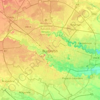
Name: Bucharest topographic map, elevation, terrain.
Location: Bucharest, Romania (44.33425 25.96667 44.54140 26.22558)
Average elevation: 269 ft
Minimum elevation: 161 ft
Maximum elevation: 384 ft
The city has an area of 226 km2 (87 sq mi). The altitude varies from 55.8 m (183.1 ft) at the Dâmbovița bridge in Cățelu, southeastern Bucharest and 91.5 m (300.2 ft) at the Militari church. The city has a roughly round shape, with the centre situated in the cross-way of the main north–south/east-west axes at University Square. The milestone for Romania's Kilometre Zero is placed just south of University Square in front of the New St. George Church (Sfântul Gheorghe Nou) at St. George Square (Piața Sfântul Gheorghe). Bucharest's radius, from University Square to the city limits in all directions, varies from 10 to 12 km (6 to 7 mi).
Other topographic maps
Click on a map to view its topography, its elevation and its terrain.
Apuseni Mountains
Romania > Cluj > Valea Ierii
Apuseni Mountains, Valea Ierii, Cluj, Romania
Average elevation: 5,299 ft
Techirghiol
Techirghiol, Constanta Metropolitan Area, Constanța, 906100, Romania
Average elevation: 75 ft
Bâsca Chiojdului
Bâsca Chiojdului, Chiojdu, Buzău, 127171, Romania
Average elevation: 2,402 ft
Mârghia de Jos
Mârghia de Jos, Lunca Corbului, Argeș, 117441, Romania
Average elevation: 869 ft
Sita
Sita, Spermezeu, Bistrița-Năsăud, 427279, Romania
Average elevation: 1,650 ft
Lacul Mărul
Romania > Caraș-Severin > Poiana Mărului
Lacul Mărul, Poiana Mărului, Zăvoi, Caraș-Severin, 327439, Romania
Average elevation: 2,713 ft
Bâlea Lake
Romania > Sibiu > Cârțișoara
Bâlea Lake, Cârțișoara, Sibiu, Romania
Average elevation: 6,824 ft