
Riverdale topographic map
Click on the map to display elevation.
About this map
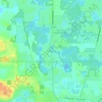
Name: Riverdale topographic map, elevation, terrain.
Location: Riverdale, Hernando County, Florida, 33593, United States (28.46278 -82.21620 28.50278 -82.17620)
Average elevation: 79 ft
Minimum elevation: 43 ft
Maximum elevation: 171 ft
Other topographic maps
Click on a map to view its topography, its elevation and its terrain.
Weeki Wachee
United States > Florida > Hernando County
Weeki Wachee features a unique and diverse topography characterized primarily by its proximity to the Weeki Wachee River and the surrounding Weeki Wachee Preserve. The area sits at a low elevation of about 33 feet above sea level, encompassing approximately 1.05 square miles, with a landscape that blends…
Average elevation: 36 ft
Brooksville
United States > Florida > Hernando County
Brooksville is known for its rolling topography with elevations ranging from 100 ft to 180 ft. The highest elevation in the area is Chinsegut Hill, at 269 ft, over five and a half miles north of the city.
Average elevation: 125 ft
Spring Lake
United States > Florida > Hernando County
Spring Lake contains rolling hills ranging in elevation from 120ft to 280ft.
Average elevation: 161 ft
Brooksville
United States > Florida > Hernando County
Brooksville is known for its rolling topography with elevations ranging from 100 ft to 180 ft. The highest elevation in the area is Chinsegut Hill, at 269 ft, over five and a half miles north of the city.
Average elevation: 125 ft
Spring Lake
United States > Florida > Hernando County > Spring Lake
Spring Lake contains rolling hills ranging in elevation from 120ft to 280ft.
Average elevation: 161 ft
Ridge Manor
United States > Florida > Hernando County > Brooksville > Ridge Manor
Average elevation: 72 ft
Brooksville
United States > Florida > Hernando County
Brooksville is known for its rolling topography with elevations ranging from 100 ft to 180 ft. The highest elevation in the area is Chinsegut Hill, at 269 ft, over five and a half miles north of the city.
Average elevation: 125 ft
Spring Lake
United States > Florida > Hernando County
Spring Lake contains rolling hills ranging in elevation from 120ft to 280ft.
Average elevation: 161 ft