
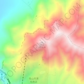
恒山 topographic map
Interactive map
Click on the map to display elevation.
About this map
Name: 恒山 topographic map, elevation, terrain.
Location: 恒山, 大同市, 山西省, 中国 (39.67161 113.72592 39.67171 113.72602)
Average elevation: 5,282 ft
Minimum elevation: 3,701 ft
Maximum elevation: 6,640 ft
恒山又名元岳、常山、北岳,明代之前指河北大茂山,清代顺治时因改祭北岳于山西省浑源县玄岳山,遂称浑源玄岳山为恒山。恒山山脉为东北-西南走向,绵延150公里。恒山主峰天峰岭海拔2016.1米,主庙北岳庙,供奉着恒山神,即北岳大帝。
Other topographic maps
Click on a map to view its topography, its elevation and its terrain.