
晋城市 topographic map
Interactive map
Click on the map to display elevation.
About this map
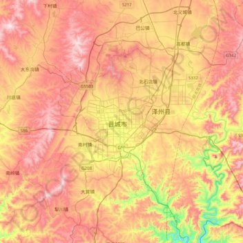
Name: 晋城市 topographic map, elevation, terrain.
Location: 晋城市, 城区, 晋城市, 山西省, 048000, 中国 (35.33378 112.69199 35.65378 113.01199)
Average elevation: 2,671 ft
Minimum elevation: 1,175 ft
Maximum elevation: 3,839 ft
境内大部分地区海拔在700m以上。海拔最高点位于境内西侧舜王坪,海拔2321.8m,最低点位于境内南部沁河、丹河下游河谷,海拔不足300m,相对高差约2000多米。
Other topographic maps
Click on a map to view its topography, its elevation and its terrain.