Hamm topographic map
Interactive map
Click on the map to display elevation.
About this map
![Hamm topographic map, elevation, terrain](/pub/maps/relation/dskl/hwfmt/thumbnail.jpg)
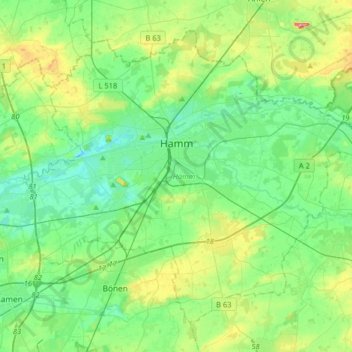
Name: Hamm topographic map, elevation, terrain.
Location: Hamm, North Rhine-Westphalia, Germany (51.57865 7.67477 51.74460 7.99744)
Average elevation: 246 ft
Minimum elevation: 151 ft
Maximum elevation: 512 ft
Other topographic maps
Click on a map to view its topography, its elevation and its terrain.
![Bochum-Mitte topographic map, elevation, terrain](/pub/maps/relation/lzmt/fwzp4s/icon.jpg)
Bochum-Mitte
Germany > North Rhine-Westphalia > Bochum
Bochum-Mitte, Bochum, North Rhine-Westphalia, Germany
Average elevation: 299 ft
![33175 topographic map, elevation, terrain](/pub/maps/relation/4gp/tbknm2/icon.jpg)
33175
Germany > North Rhine-Westphalia > Kreis Paderborn > Bad Lippspringe
33175, Bad Lippspringe, Kreis Paderborn, North Rhine-Westphalia, Germany
Average elevation: 489 ft
![Hamberg topographic map, elevation, terrain](/pub/maps/node/fhs8/tccsrpnx/icon.jpg)
Hamberg
Germany > North Rhine-Westphalia > Kreis Lippe > Lügde
Hamberg, Lügde, Kreis Lippe, North Rhine-Westphalia, 31812, Germany
Average elevation: 646 ft
![Zülpich topographic map, elevation, terrain](/pub/maps/relation/jpt6/nsccz/icon.jpg)
Zülpich
Germany > North Rhine-Westphalia > Kreis Euskirchen
Zülpich, Kreis Euskirchen, North Rhine-Westphalia, 53909, Germany
Average elevation: 607 ft
![Busch topographic map, elevation, terrain](/pub/maps/node/xh3l/rp25dzf3/icon.jpg)
Busch
Germany > North Rhine-Westphalia > Kreis Viersen > Dülken
Busch, Dülken, Viersen, Kreis Viersen, North Rhine-Westphalia, 41751, Germany
Average elevation: 217 ft
![Monheim am Rhein topographic map, elevation, terrain](/pub/maps/relation/d24s/89k9m/icon.jpg)
Monheim am Rhein
Germany > North Rhine-Westphalia > Kreis Mettmann
Monheim am Rhein, Kreis Mettmann, North Rhine-Westphalia, 40789, Germany
Average elevation: 138 ft
![Büderich topographic map, elevation, terrain](/pub/maps/relation/f9m/qx8j4s/icon.jpg)
Büderich
Germany > North Rhine-Westphalia > Kreis Wesel > Wesel
Büderich, Wesel, Kreis Wesel, North Rhine-Westphalia, Germany
Average elevation: 69 ft
![Gescher topographic map, elevation, terrain](/pub/maps/relation/x557/v633q/icon.jpg)
Gescher
Germany > North Rhine-Westphalia > Kreis Borken
Gescher, Kreis Borken, North Rhine-Westphalia, 48712, Germany
Average elevation: 210 ft
![Dusseldorf topographic map, elevation, terrain](/pub/maps/node/xs4s/bvqv94s/icon.jpg)
Dusseldorf
Germany > North Rhine-Westphalia
Dusseldorf, North Rhine-Westphalia, Germany
Average elevation: 207 ft
![Herford topographic map, elevation, terrain](/pub/maps/relation/z7nx/nzmcz/icon.jpg)
Herford
Germany > North Rhine-Westphalia > Kreis Herford
Herford, Kreis Herford, North Rhine-Westphalia, Germany
Average elevation: 351 ft
![Cleves topographic map, elevation, terrain](/pub/maps/relation/955k/rdpctj/icon.jpg)
Cleves
Germany > North Rhine-Westphalia > Kreis Kleve > Cleves
Cleves, Bedburg-Hau, Kreis Kleve, North Rhine-Westphalia, 47533, Germany
Average elevation: 115 ft
![Garsbeck topographic map, elevation, terrain](/pub/maps/node/2tj/bm22jf3/icon.jpg)
Garsbeck
Germany > North Rhine-Westphalia > Kreis Heinsberg > Hückelhoven
Garsbeck, Hückelhoven, Kreis Heinsberg, North Rhine-Westphalia, 41849, Germany
Average elevation: 161 ft
![Beckum topographic map, elevation, terrain](/pub/maps/relation/8cz4/67ss8/icon.jpg)
Beckum
Germany > North Rhine-Westphalia > Kreis Warendorf
Beckum, Kreis Warendorf, North Rhine-Westphalia, 59269, Germany
Average elevation: 361 ft
![Hückelhoven topographic map, elevation, terrain](/pub/maps/relation/hlcz/qn6nx/icon.jpg)
Hückelhoven
Germany > North Rhine-Westphalia > Kreis Heinsberg
Hückelhoven, Kreis Heinsberg, North Rhine-Westphalia, 41836, Germany
Average elevation: 230 ft
![Krupp-Park topographic map, elevation, terrain](/pub/maps/way/83q/wwhzx3l/icon.jpg)
Krupp-Park
Germany > North Rhine-Westphalia > Essen
Krupp-Park, Westviertel, Stadtbezirk I, Essen, North Rhine-Westphalia, 45143, Germany
Average elevation: 220 ft
![Hambacher See topographic map, elevation, terrain](/pub/maps/way/4vgt/hrczgtp/icon.jpg)
Hambacher See
Germany > North Rhine-Westphalia > Kreis Düren > Hambach
Hambacher See, Hambach, Niederzier, Kreis Düren, North Rhine-Westphalia, 52382, Germany
Average elevation: 443 ft
![Vinning topographic map, elevation, terrain](/pub/maps/node/sf14/g2wvm14/icon.jpg)
Vinning
Germany > North Rhine-Westphalia > Kreis Unna > Unna
Vinning, Unna, Kreis Unna, North Rhine-Westphalia, Germany
Average elevation: 541 ft
![Borgentreich topographic map, elevation, terrain](/pub/maps/relation/819m/nwkn51/icon.jpg)
Borgentreich
Germany > North Rhine-Westphalia > Kreis Höxter
Borgentreich, Kreis Höxter, North Rhine-Westphalia, 34434, Germany
Average elevation: 764 ft
![Rheda-Wiedenbrück topographic map, elevation, terrain](/pub/maps/relation/bb3l/l6z18/icon.jpg)
Rheda-Wiedenbrück
Germany > North Rhine-Westphalia > Kreis Gütersloh
Rheda-Wiedenbrück, Kreis Gütersloh, North Rhine-Westphalia, 33378, Germany
Average elevation: 262 ft
![Rhein-Sieg-Kreis topographic map, elevation, terrain](/pub/maps/relation/l818/625tf/icon.jpg)
Rhein-Sieg-Kreis
Germany > North Rhine-Westphalia
Rhein-Sieg-Kreis, North Rhine-Westphalia, Germany
Average elevation: 696 ft
![Kreis Warendorf topographic map, elevation, terrain](/pub/maps/relation/c1tj/v77m2/icon.jpg)
Kreis Warendorf
Germany > North Rhine-Westphalia
Kreis Warendorf, North Rhine-Westphalia, Germany
Average elevation: 243 ft
![Nordwalde topographic map, elevation, terrain](/pub/maps/relation/1wtj/6w618/icon.jpg)
Nordwalde
Germany > North Rhine-Westphalia > Kreis Steinfurt
Nordwalde, Kreis Steinfurt, North Rhine-Westphalia, 48356, Germany
Average elevation: 177 ft
![In der Frack topographic map, elevation, terrain](/pub/maps/node/k618/kd3x9151/icon.jpg)
In der Frack
Germany > North Rhine-Westphalia > Kreis Düren > Linnich > Welz
In der Frack, Welz, Linnich, Kreis Düren, North Rhine-Westphalia, 52441, Germany
Average elevation: 256 ft
![Bochum-Süd topographic map, elevation, terrain](/pub/maps/relation/csnx/dgchkl/icon.jpg)
Bochum-Süd
Germany > North Rhine-Westphalia > Bochum
Bochum-Süd, Bochum, North Rhine-Westphalia, Germany
Average elevation: 377 ft
![Sauerland topographic map, elevation, terrain](/pub/maps/way/f7gp/zljc4gp/icon.jpg)
Sauerland
Germany > North Rhine-Westphalia > Eslohe
Sauerland, Eslohe, Hochsauerlandkreis, Regierungsbezirk Arnsberg, North Rhine-Westphalia, Germany
Average elevation: 1,053 ft
![Liblar topographic map, elevation, terrain](/pub/maps/node/8kl/jjwl3zs/icon.jpg)
Liblar
Germany > North Rhine-Westphalia > Rhein-Erft-Kreis
Liblar, Erftstadt, Rhein-Erft-Kreis, North Rhine-Westphalia, 50374, Germany
Average elevation: 361 ft
![Viersen topographic map, elevation, terrain](/pub/maps/relation/b7kl/3qd14/icon.jpg)
Viersen
Germany > North Rhine-Westphalia > Kreis Viersen
Viersen, Kreis Viersen, North Rhine-Westphalia, Germany
Average elevation: 167 ft
![Struberg topographic map, elevation, terrain](/pub/maps/node/fqb3/dqj3kn3q/icon.jpg)
Struberg
Germany > North Rhine-Westphalia > Kreis Minden-Lübbecke > Hüllhorst
Struberg, Hüllhorst, Kreis Minden-Lübbecke, North Rhine-Westphalia, 32312, Germany
Average elevation: 627 ft
![Hürtgenwald topographic map, elevation, terrain](/pub/maps/relation/cbtj/sq3gp/icon.jpg)
Hürtgenwald
Germany > North Rhine-Westphalia > Kreis Düren
Hürtgenwald, Kreis Düren, North Rhine-Westphalia, 52393, Germany
Average elevation: 1,099 ft
![Preußisch Oldendorf topographic map, elevation, terrain](/pub/maps/relation/kk4s/jk3nx/icon.jpg)
Preußisch Oldendorf
Germany > North Rhine-Westphalia > Kreis Minden-Lübbecke
Preußisch Oldendorf, Kreis Minden-Lübbecke, North Rhine-Westphalia, 32361, Germany
Average elevation: 276 ft
![Börninghausen topographic map, elevation, terrain](/pub/maps/node/xz57/gnbsrcz/icon.jpg)
Börninghausen
Germany > North Rhine-Westphalia > Kreis Minden-Lübbecke > Preußisch Oldendorf
Börninghausen, Preußisch Oldendorf, Kreis Minden-Lübbecke, North Rhine-Westphalia, 32361, Germany
Average elevation: 443 ft
![NSG Kamptal topographic map, elevation, terrain](/pub/maps/way/prr/628ntgt/icon.jpg)
NSG Kamptal
Germany > North Rhine-Westphalia > Essen
NSG Kamptal, Heißener Straße, Schönebeck, Stadtbezirk IV, Essen, North Rhine-Westphalia, 45359, Germany
Average elevation: 259 ft
![Paradiesstrand topographic map, elevation, terrain](/pub/maps/way/mrr/3hvf41h/icon.jpg)
Paradiesstrand
Germany > North Rhine-Westphalia > Dusseldorf
Paradiesstrand, Hafen, Stadtbezirk 3, Dusseldorf, North Rhine-Westphalia, 40221, Germany
Average elevation: 115 ft
![Stadtlohn topographic map, elevation, terrain](/pub/maps/relation/6jkl/722b3/icon.jpg)
Stadtlohn
Germany > North Rhine-Westphalia > Kreis Borken
Stadtlohn, Kreis Borken, North Rhine-Westphalia, 48703, Germany
Average elevation: 177 ft
![Gelsenkirchen topographic map, elevation, terrain](/pub/maps/relation/4ttp/drg3l/icon.jpg)
Gelsenkirchen
Germany > North Rhine-Westphalia
Gelsenkirchen, North Rhine-Westphalia, Germany
Average elevation: 187 ft
![Großer Laacher See topographic map, elevation, terrain](/pub/maps/way/9ltf/fd7jnh/icon.jpg)
Großer Laacher See
Germany > North Rhine-Westphalia > Leverkusen
Großer Laacher See, Hitdorf, Stadtbezirk I, Leverkusen, North Rhine-Westphalia, 51371, Germany
Average elevation: 138 ft
![Lüderich topographic map, elevation, terrain](/pub/maps/node/4nh/cg7pk18/icon.jpg)
Lüderich
Germany > North Rhine-Westphalia > Rheinisch-Bergischer Kreis > Rösrath
Lüderich, Rösrath, Rheinisch-Bergischer Kreis, North Rhine-Westphalia, 51503, Germany
Average elevation: 551 ft
![Harsewinkel topographic map, elevation, terrain](/pub/maps/relation/xxs8/sqn1h/icon.jpg)
Harsewinkel
Germany > North Rhine-Westphalia > Kreis Gütersloh
Harsewinkel, Kreis Gütersloh, North Rhine-Westphalia, 33428, Germany
Average elevation: 226 ft
![Hahn topographic map, elevation, terrain](/pub/maps/relation/23tj/2w42f3/icon.jpg)
Hahn
Germany > North Rhine-Westphalia > Oberbergischer Kreis > Wiehl > Brächen
Hahn, Brächen, Wiehl, Oberbergischer Kreis, North Rhine-Westphalia, 51674, Germany
Average elevation: 909 ft
![Hilden topographic map, elevation, terrain](/pub/maps/relation/twcz/1wnrr/icon.jpg)
Hilden
Germany > North Rhine-Westphalia > Kreis Mettmann
Hilden, Kreis Mettmann, North Rhine-Westphalia, Germany
Average elevation: 180 ft
![Bestwig topographic map, elevation, terrain](/pub/maps/relation/wh3l/dgf9m/icon.jpg)
Bestwig
Germany > North Rhine-Westphalia > Hochsauerlandkreis
Bestwig, Hochsauerlandkreis, North Rhine-Westphalia, 59909, Germany
Average elevation: 1,529 ft
![Bad Lippspringe topographic map, elevation, terrain](/pub/maps/relation/fgmt/6s318/icon.jpg)
Bad Lippspringe
Germany > North Rhine-Westphalia > Kreis Paderborn
Bad Lippspringe, Kreis Paderborn, North Rhine-Westphalia, 33175, Germany
Average elevation: 630 ft
![Warburg topographic map, elevation, terrain](/pub/maps/relation/snb3/mqbm1h/icon.jpg)
Warburg
Germany > North Rhine-Westphalia > Kreis Höxter
Warburg, Kreis Höxter, North Rhine-Westphalia, 34414, Germany
Average elevation: 814 ft
![Schmidt topographic map, elevation, terrain](/pub/maps/node/tsm2/gkgvq18/icon.jpg)
Schmidt
Germany > North Rhine-Westphalia > Kreis Düren
Schmidt, Nideggen, Kreis Düren, North Rhine-Westphalia, Germany
Average elevation: 1,237 ft
![Pöting topographic map, elevation, terrain](/pub/maps/node/lgf3/rzv7cgtj/icon.jpg)
Pöting
Germany > North Rhine-Westphalia > Ennepe-Ruhr-Kreis > Sprockhövel
Pöting, Sprockhövel, Ennepe-Ruhr-Kreis, North Rhine-Westphalia, 45549, Germany
Average elevation: 728 ft
![SO2 topographic map, elevation, terrain](/pub/maps/node/d2mt/7p9f8t3l/icon.jpg)
SO2
Germany > North Rhine-Westphalia > Kreis Borken > Bocholt
SO2, Bocholt, Kreis Borken, North Rhine-Westphalia, 46397, Germany
Average elevation: 105 ft
![Zerkall topographic map, elevation, terrain](/pub/maps/node/fhnh/92h43gp/icon.jpg)
Zerkall
Germany > North Rhine-Westphalia > Kreis Düren > Hürtgenwald
Zerkall, Hürtgenwald, Kreis Düren, North Rhine-Westphalia, 52385, Germany
Average elevation: 906 ft
![Wadersloh topographic map, elevation, terrain](/pub/maps/relation/vk51/9k3kl/icon.jpg)
Wadersloh
Germany > North Rhine-Westphalia > Kreis Warendorf
Wadersloh, Kreis Warendorf, North Rhine-Westphalia, Germany
Average elevation: 285 ft
![Heistern topographic map, elevation, terrain](/pub/maps/node/31gp/v3n2gnx/icon.jpg)
Heistern
Germany > North Rhine-Westphalia > Kreis Düren
Heistern, Langerwehe, Kreis Düren, North Rhine-Westphalia, 52379, Germany
Average elevation: 643 ft
![Hommerich topographic map, elevation, terrain](/pub/maps/node/k24s/7z81g53l/icon.jpg)
Hommerich
Germany > North Rhine-Westphalia > Rhein-Sieg-Kreis > Hennef (Sieg) > Hofen
Hommerich, Hofen, Hennef (Sieg), Rhein-Sieg-Kreis, North Rhine-Westphalia, 53773, Germany
Average elevation: 512 ft