
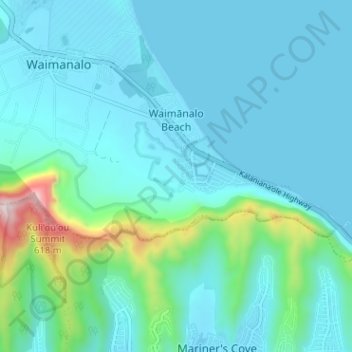
Waimanalo Beach topographic map
Interactive map
Click on the map to display elevation.
About this map
Name: Waimanalo Beach topographic map, elevation, terrain.
Average elevation: 315 ft
Minimum elevation: -20 ft
Maximum elevation: 2,247 ft
Other topographic maps
Click on a map to view its topography, its elevation and its terrain.
Oʻahu
United States > Hawaii > Honolulu County
Oʻahu, Honolulu County, Hawaii, United States
Average elevation: 259 ft
Honolulu
United States > Hawaii > Honolulu County
Honolulu, Honolulu County, Hawaii, United States
Average elevation: 187 ft
Helemano Stream
United States > Hawaii > Honolulu County > Haleiwa
Helemano Stream, Haleiwa, Honolulu County, Hawaii, 96712, United States
Average elevation: 115 ft
Waimanalo
United States > Hawaii > Honolulu County > Waimanalo
Waimanalo, Honolulu County, Hawaii, United States
Average elevation: 72 ft
Marine Corps Base Hawaii Kaneohe
United States > Hawaii > Honolulu County > Kaneohe
Marine Corps Base Hawaii Kaneohe, Kaneohe, Honolulu County, Hawaii, 96863, United States
Average elevation: 23 ft
Akupu
United States > Hawaii > Honolulu County > Kapolei
Akupu, Kapolei, Honolulu County, Hawaii, United States
Average elevation: 1,598 ft
‘Āina Haina
United States > Hawaii > Honolulu County > East Honolulu
‘Āina Haina, East Honolulu, Honolulu, Honolulu County, Hawaii, United States
Average elevation: 863 ft
Ko Olina
United States > Hawaii > Honolulu County > Kapolei
Ko Olina, Kapolei, Honolulu County, Hawaii, United States
Average elevation: 16 ft
Punaluu
United States > Hawaii > Honolulu County
Punaluu, Honolulu County, Hawaii, United States
Average elevation: 154 ft
Hawaii Kai Ridge & Cove
United States > Hawaii > Honolulu County > East Honolulu
Hawaii Kai Ridge & Cove, East Honolulu, Honolulu, Honolulu County, Hawaii, United States
Average elevation: 404 ft
Kunia Camp
United States > Hawaii > Honolulu County
Kunia Camp, Honolulu County, Hawaii, 96759, United States
Average elevation: 968 ft
Waipio Acres
United States > Hawaii > Honolulu County > Mililani
Waipio Acres, Mililani, Honolulu County, Hawaii, United States
Average elevation: 755 ft
Whitmore Village
United States > Hawaii > Honolulu County > Wahiawā > Whitmore Village
Whitmore Village, Wahiawā, Honolulu County, Hawaii, United States
Average elevation: 978 ft
Makaha Valley
United States > Hawaii > Honolulu County > Mākaha Valley
Makaha Valley, Mākaha Valley, Honolulu County, Hawaii, United States
Average elevation: 568 ft
Kawela Bay
United States > Hawaii > Honolulu County
Kawela Bay, Kawela, Honolulu County, Hawaii, United States
Average elevation: 69 ft
Kahuku
United States > Hawaii > Honolulu County
Kahuku, Honolulu County, Hawaii, United States
Average elevation: 26 ft
Wahiawa
United States > Hawaii > Honolulu County
Wahiawa, Honolulu County, Hawaii, 96786, United States
Average elevation: 974 ft
Lanikai Beach
United States > Hawaii > Honolulu County > Kailua
Lanikai Beach, Lanikai, Kailua, Honolulu County, Hawaii, United States
Average elevation: 52 ft
Nanakuli
United States > Hawaii > Honolulu County
Nanakuli, Honolulu County, Hawaii, United States
Average elevation: 180 ft
Maili
United States > Hawaii > Honolulu County > Kapolei
Maili, Mā‘ili, Kapolei, Honolulu County, Hawaii, United States
Average elevation: 20 ft
Pearl Harbor
United States > Hawaii > Honolulu County > Pearl City
Pearl Harbor, Pearl City, Honolulu County, Hawaii, United States
Average elevation: 62 ft
Kaneohe
United States > Hawaii > Honolulu County
Kaneohe, Honolulu County, Hawaii, 96744, United States
Average elevation: 344 ft
Makaha
United States > Hawaii > Honolulu County
Makaha, Honolulu County, Hawaii, United States
Average elevation: 177 ft
Waimalu
United States > Hawaii > Honolulu County > Pearl City
Waimalu, Aiea, Honolulu County, Hawaii, 96701, United States
Average elevation: 338 ft
Hickam Housing
United States > Hawaii > Honolulu County > Waipahu
Hickam Housing, Hickam, Aiea, Honolulu County, Hawaii, United States
Average elevation: 16 ft
Mililani Mauka
United States > Hawaii > Honolulu County > Mililani
Mililani Mauka, Mililani, Honolulu County, Hawaii, United States
Average elevation: 833 ft
Honolulu
United States > Hawaii > Honolulu County
Honolulu, Honolulu County, Hawaii, 96813, United States
Average elevation: 233 ft
Ewa Beach
United States > Hawaii > Honolulu County
Ewa Beach, Honolulu County, Hawaii, 96706, United States
Average elevation: 20 ft
Diamond Head
United States > Hawaii > Honolulu County > Honolulu
Diamond Head, Honolulu, Honolulu County, Hawaii, 96186, United States
Average elevation: 102 ft
Hawaii Kai
United States > Hawaii > Honolulu County > Honolulu
Hawaii Kai, Honolulu, Honolulu County, Hawaii, United States
Average elevation: 371 ft
Waikāne
United States > Hawaii > Honolulu County
Waikāne, Honolulu County, Hawaii, United States
Average elevation: 243 ft
Kapunahala
United States > Hawaii > Honolulu County > Kaneohe
Kapunahala, Kaneohe, Honolulu County, Hawaii, 96744, United States
Average elevation: 299 ft
Kapolei
United States > Hawaii > Honolulu County
Kapolei, Honolulu County, Hawaii, 96707, United States
Average elevation: 253 ft
Aiea
United States > Hawaii > Honolulu County
Aiea, Honolulu County, Hawaii, United States
Average elevation: 295 ft
Hahaione Valley
United States > Hawaii > Honolulu County > Honolulu
Hahaione Valley, Honolulu, Honolulu County, Hawaii, United States
Average elevation: 486 ft
‘Āhuimanu
United States > Hawaii > Honolulu County
‘Āhuimanu, Honolulu County, Hawaii, 96744, United States
Average elevation: 315 ft
Waiale‘e
United States > Hawaii > Honolulu County
Waiale‘e, Honolulu County, Hawaii, United States
Average elevation: 180 ft
Laie
United States > Hawaii > Honolulu County
Laie, Honolulu County, Hawaii, 96762, United States
Average elevation: 62 ft
Kokokahi
United States > Hawaii > Honolulu County > Kaneohe
Kokokahi, Kaneohe, Honolulu County, Hawaii, 96744, United States
Average elevation: 89 ft
Schofield Barracks
United States > Hawaii > Honolulu County > Mililani
Schofield Barracks, Honolulu County, Hawaii, United States
Average elevation: 915 ft
Mililani Town
United States > Hawaii > Honolulu County
Mililani Town, Honolulu County, Hawaii, 96789, United States
Average elevation: 604 ft
Hauula
United States > Hawaii > Honolulu County
Hauula, Honolulu County, Hawaii, 96717, United States
Average elevation: 863 ft
Diamond Head
United States > Hawaii > Honolulu County > Honolulu
Diamond Head, Honolulu, Honolulu County, Hawaii, 96815, United States
Average elevation: 85 ft
Joint Base Pearl Harbor-Hickam
United States > Hawaii > Honolulu County > Waipahu
Joint Base Pearl Harbor-Hickam, Waipahu, Honolulu County, Hawaii, 96853, United States
Average elevation: 23 ft
Kahaluu
United States > Hawaii > Honolulu County > Kailua > Kahalu‘u
Kahaluu, Kahalu‘u, Kailua, Honolulu County, Hawaii, United States
Average elevation: 105 ft
Heeia
United States > Hawaii > Honolulu County
Heeia, Honolulu County, Hawaii, United States
Average elevation: 325 ft
Ala Moana Beach
United States > Hawaii > Honolulu County > Honolulu
Ala Moana Beach, Ala Moana, Honolulu, Honolulu County, Hawaii, United States
Average elevation: 13 ft
Waialua
United States > Hawaii > Honolulu County
Waialua, Honolulu County, Hawaii, United States
Average elevation: 52 ft
East Honolulu
United States > Hawaii > Honolulu County
East Honolulu, Honolulu, Honolulu County, Hawaii, 96825, United States
Average elevation: 164 ft
Pupukea
United States > Hawaii > Honolulu County > Waiale‘e
Pupukea, Waiale‘e, Honolulu County, Hawaii, United States
Average elevation: 167 ft