
Aisholt topographic map
Click on the map to display elevation.
About this map
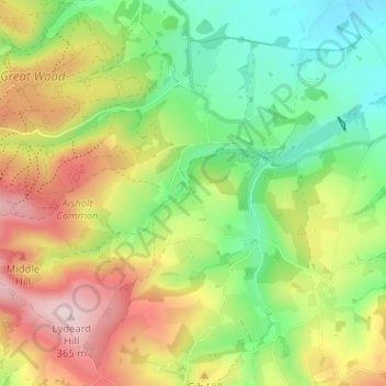
Name: Aisholt topographic map, elevation, terrain.
Location: Aisholt, Spaxton, Somerset, England, TA5 1AR, United Kingdom (51.09404 -3.17300 51.13404 -3.13300)
Average elevation: 623 ft
Minimum elevation: 207 ft
Maximum elevation: 1,194 ft
Other topographic maps
Click on a map to view its topography, its elevation and its terrain.
Priddy
United Kingdom > England > Somerset
The village lies in a small hollow near the summit of the Mendip range of hills, at an elevation of nearly 1,000 feet (300 m) above sea-level, and has evidence of occupation since neolithic times. There are remains of lead mining activities and caves in the limestone beneath the village.
Average elevation: 676 ft
Small Brook
United Kingdom > England > Somerset > South Somerset > Haselbury Plucknett
Average elevation: 157 ft
Kingsdown Clump
United Kingdom > England > Somerset > Roadwater > Nettlecombe
Average elevation: 584 ft
Quantock Hills National Landscape
United Kingdom > England > Somerset > Over Stowey
Average elevation: 381 ft
Mendip Hills National Landscape
United Kingdom > England > Somerset > Priddy
Average elevation: 351 ft
Mells Park
United Kingdom > England > Somerset > Vobster
The architect Edwin Lutyens had known the Horners, and Mells Park, since 1896. In 1918 he unsuccessfully tried to persuade the Horners to rebuild Park House. However, Reginald McKenna, the chairman of Midland Bank, and formerly Home Secretary and Chancellor of the Exchequer under Asquith, was married to Pamela…
Average elevation: 440 ft