
Make a donation
Gear up for your next adventure:
As an Amazon Associate, this site earns from qualifying purchases at no extra cost to you.
Guayama topographic map
Click on the map to display elevation.
Make a donation
Gear up for your next adventure:
As an Amazon Associate, this site earns from qualifying purchases at no extra cost to you.
Guayama
The Municipality of Guayama is located on the Southern Coastal Valley region, bordering the Caribbean Sea, south of Cayey; east of Salinas; and west of Patillas and Arroyo. Guayama's municipal territory reaches the central mountain range to the north and the Caribbean Sea to the south. The mountain systems Sierra de Jájome (2,395 feet or 730 meters) and Sierra de Cayey cover some of the municipality area. The highest points are the Cerro de la Tabla (2,834 feet or 863 meters) and Cerro Tumbado (2,450 feet or 746 meters), which are part of the Sierra de Cayey mountain system. Other elevations are the mountains Garau, Charcas and Peña Hendida. Parts of the Guavate-Carite Forest and the Aguirre State Forest are in Guayama. The Guavate-Carite Forest, a 6,000-acre nature reserve is inhabited by 50 species of birds, making this spot a recognized area for birding and has a reserve with a dwarf forest that was produced by the region's high humidity and moist soil. The Aguirre Forest includes: mangroves, tidal flats, bird rookeries, research lakes & large manatee population. The Jobos Bay National Estuarine Research Reserve was established in 1987. The reserve is located between the coasts of Salinas and Guayama, approximately 2,883 acres of mangrove forest and freshwater wetlands. The two main components: Mar Negro mangrove forest, which consists of a mangrove forest and a complex system of lagoons and channels interspersed with salt and mud flats; and Cayos Caribe Islets, which are surrounded by coral reefs and seagrass beds, with small beach deposits and upland areas.
Make a donation
Gear up for your next adventure:
As an Amazon Associate, this site earns from qualifying purchases at no extra cost to you.
About this map
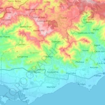
Name: Guayama topographic map, elevation, terrain.
Location: Guayama, Puerto Rico, United States (17.92839 -66.21349 18.10760 -66.05307)
Average elevation: 899 ft
Minimum elevation: -7 ft
Maximum elevation: 2,907 ft
Puerto Rico trails, hiking, mountain biking, running and outdoor activities
Make a donation
Gear up for your next adventure:
As an Amazon Associate, this site earns from qualifying purchases at no extra cost to you.
Other topographic maps
Click on a map to view its topography, its elevation and its terrain.
Make a donation
Gear up for your next adventure:
As an Amazon Associate, this site earns from qualifying purchases at no extra cost to you.
Make a donation
Gear up for your next adventure:
As an Amazon Associate, this site earns from qualifying purchases at no extra cost to you.
Make a donation
Gear up for your next adventure:
As an Amazon Associate, this site earns from qualifying purchases at no extra cost to you.
Isla de Mona
United States > Puerto Rico > Mayagüez
Mona is a mainly flat plateau surrounded by sea cliffs. It is composed of dolomite and limestone with many caves found throughout. With an arid climate and untouched by human development, many endemic species inhabit the island, such as the Mona ground iguana (Cyclura cornuta stejnegeri). Its topography,…
Average elevation: 85 ft
Make a donation
Gear up for your next adventure:
As an Amazon Associate, this site earns from qualifying purchases at no extra cost to you.
Make a donation
Gear up for your next adventure:
As an Amazon Associate, this site earns from qualifying purchases at no extra cost to you.
Comunidad Miraflores
United States > Puerto Rico > Las Piedras > Las Piedras
Average elevation: 509 ft
Make a donation
Gear up for your next adventure:
As an Amazon Associate, this site earns from qualifying purchases at no extra cost to you.
Make a donation
Gear up for your next adventure:
As an Amazon Associate, this site earns from qualifying purchases at no extra cost to you.
Make a donation
Gear up for your next adventure:
As an Amazon Associate, this site earns from qualifying purchases at no extra cost to you.
Mayagüez
United States > Puerto Rico > Mayagüez
Mayagüez has a tropical monsoon climate (Köppen climate classification Am). The city has the most extreme weather of the island. The high frequency of severe storms in the summer can produce strong winds, floods, waterspouts, and sometimes hail and even tornadoes. The average annual temperature is 75 °F (24…
Average elevation: 305 ft
Make a donation
Gear up for your next adventure:
As an Amazon Associate, this site earns from qualifying purchases at no extra cost to you.
Make a donation
Gear up for your next adventure:
As an Amazon Associate, this site earns from qualifying purchases at no extra cost to you.
Cayey
United States > Puerto Rico > Cayey
Cayey's climate is humid, rainy and mild compared to lower-elevation areas of the island, the area of the town is nearly 1,500 feet (460 m) high, so the climate is subtropical high. In summer average high Temperatures are around 82 °F to 88 °F and 70 °F to 78 °F in winter, and low around 68 °F to 72 °F…
Average elevation: 1,604 ft
Gozalandia Waterfall
United States > Puerto Rico > San Sebastián > San Sebastián
Average elevation: 577 ft
Make a donation
Gear up for your next adventure:
As an Amazon Associate, this site earns from qualifying purchases at no extra cost to you.
Make a donation
Gear up for your next adventure:
As an Amazon Associate, this site earns from qualifying purchases at no extra cost to you.
Make a donation
Gear up for your next adventure:
As an Amazon Associate, this site earns from qualifying purchases at no extra cost to you.
Ceiba
United States > Puerto Rico > Ceiba
The highest point in the municipality is Pico del Oeste in the Sierra de Luquillo at 3,346 feet (1,020 m) of elevation.
Average elevation: 164 ft
Make a donation
Gear up for your next adventure:
As an Amazon Associate, this site earns from qualifying purchases at no extra cost to you.
Make a donation
Gear up for your next adventure:
As an Amazon Associate, this site earns from qualifying purchases at no extra cost to you.
Cerro de Punta
United States > Puerto Rico > Ponce
The mountain is part of the Cordillera Central and is located on the border between the municipalities of Jayuya and Ponce. The access road to the point closest to the highest elevation is from the municipality of Jayuya. It is part of the Toro Negro Forest Reserve, and it has been described as "an alpine…
Average elevation: 3,350 ft
Make a donation
Gear up for your next adventure:
As an Amazon Associate, this site earns from qualifying purchases at no extra cost to you.
Make a donation
Gear up for your next adventure:
As an Amazon Associate, this site earns from qualifying purchases at no extra cost to you.
Villalba
United States > Puerto Rico > Villalba > Villalba
Villalba is located in the central region of Puerto Rico, on a valley in the Cordillera Central. The highest point in the municipality is Cerro El Bolo at 3,526 feet (1,075 m) of elevation.
Average elevation: 1,332 ft
Make a donation
Gear up for your next adventure:
As an Amazon Associate, this site earns from qualifying purchases at no extra cost to you.
Make a donation
Gear up for your next adventure:
As an Amazon Associate, this site earns from qualifying purchases at no extra cost to you.
Make a donation
Gear up for your next adventure:
As an Amazon Associate, this site earns from qualifying purchases at no extra cost to you.