Geolocate

Logan topographic map

Click on the map to display elevation.

About this map

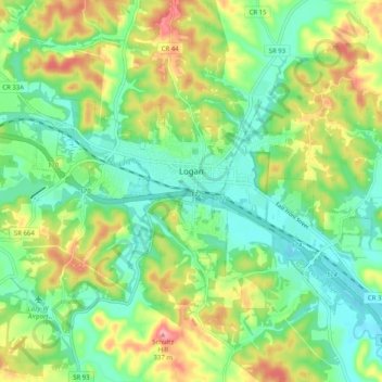
Name: Logan topographic map, elevation, terrain.

Location: Logan, Hocking County, Ohio, 43138, United States (39.51046 -82.46156 39.56086 -82.36054)

Average elevation: 833 ft

Minimum elevation: 682 ft

Maximum elevation: 1,102 ft

Hocking County trails, hiking, mountain biking, running and outdoor activities

Other topographic maps

Click on a map to view its topography, its elevation and its terrain.

Rose Lake

United States > Ohio > Hocking County

Average elevation: 968 ft

Rose Lake Dam

United States > Ohio > Hocking County

Average elevation: 974 ft

Rockbridge

United States > Ohio > Hocking County

Average elevation: 860 ft

Webb Summit

United States > Ohio > Hocking County

Average elevation: 886 ft

Sand Run

United States > Ohio > Hocking County

Average elevation: 843 ft

Starr

United States > Ohio > Hocking County

Average elevation: 896 ft

Union Furnace

United States > Ohio > Hocking County

Average elevation: 879 ft

Longstreth

United States > Ohio > Hocking County

Average elevation: 856 ft

Monday

United States > Ohio > Hocking County

Average elevation: 853 ft

Old Gore

United States > Ohio > Hocking County

Average elevation: 850 ft

Orbiston

United States > Ohio > Hocking County

Average elevation: 840 ft

Haynes

United States > Ohio > Hocking County

Average elevation: 837 ft

Jobs

United States > Ohio > Hocking County

Average elevation: 850 ft

Gore

United States > Ohio > Hocking County

Average elevation: 850 ft

Greendale

United States > Ohio > Hocking County

Average elevation: 817 ft

Gibisonville

United States > Ohio > Hocking County

Average elevation: 1,053 ft

Carbon Hill

United States > Ohio > Hocking County

Average elevation: 840 ft

Buena Vista

United States > Ohio > Hocking County

Average elevation: 1,030 ft

Enterprise

United States > Ohio > Hocking County

Average elevation: 843 ft

Ewing

United States > Ohio > Hocking County

Average elevation: 912 ft

South Bloomingville

United States > Ohio > Hocking County

Average elevation: 886 ft

Gear up for your next adventure:

🌡️Handheld Weather Meters - Measure wind, temp, and pressure for safe mountain travel
🖼️Topo Map Wall Art - Decorative topographic prints of famous peaks and regions
🏕️Family Camping Gear - Essentials for group camping trips
🧢Outdoor Hiking Hat - Sun protection hat for outdoor explorers
🔦Compact Flashlight - Reliable flashlight for emergencies

As an Amazon Associate, this site earns from qualifying purchases at no extra cost to you.