
Monroe topographic map
Click on the map to display elevation.
About this map
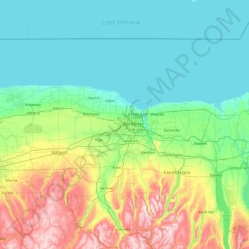
Name: Monroe topographic map, elevation, terrain.
Location: Monroe, New York, 14606, United States (42.45009 -78.38101 43.85009 -76.98101)
Average elevation: 653 ft
Minimum elevation: 236 ft
Maximum elevation: 2,251 ft
New York trails, hiking, mountain biking, running and outdoor activities
Other topographic maps
Click on a map to view its topography, its elevation and its terrain.
Cayuga Lake
United States > New York > Cayuga County > Village of Union Springs
Average elevation: 866 ft
Copake Lake
United States > New York > Columbia County > Town of Copake > Copake Lake
Average elevation: 771 ft
Burdett
United States > New York > Schuyler County > Burdett > Town of Hector
Average elevation: 932 ft
Catskill Park
New York's wilderness areas must be composed of 10,000 acres (4,000 ha; 40 km2) of contiguous land, twice the federal standard. Land is to be left as "untrammeled by man" and as close to its natural state as possible, offering outstanding opportunities for solitude. No artificially-powered devices are…
Average elevation: 1,644 ft
John Boyd Thacher State Park
United States > New York > Albany County > Town of New Scotland
The escarpment features rocks of the Upper Silurian and Upper and Middle Ordovician ages resting below the Devonian rocks. At the base of the escarpment, the Schenectady beds are visible. The Rondout "waterlime" or dolomite overlies the Schenectady beds and is most pronounced below Minelot Falls. The…
Average elevation: 860 ft
Genesee River
Only a small creek (Irondequoit Creek) flows in what is left of this large paleogeologic valley. The area of the lower river was also affected. Since the earth rebounded from the melting glaciers more rapidly in Canada than in New York, water from Lake Ontario was spilled over New York due to its lower…
Average elevation: 1,302 ft
Washington Heights
United States > New York > New York
Because of their abrupt, hilly topography, pedestrian navigation in Upper Manhattan is facilitated by many step streets. The longest of these in Washington Heights, at approximately 130 stairs and with an elevation gain of approximately 65 feet, connects Fort Washington Avenue and Overlook Terrace at 187th…
Average elevation: 82 ft
Great Sacandaga Lake
United States > New York > Fulton County > Town of Hadley
Average elevation: 1,214 ft
Averill Park
United States > New York > Rensselaer County > Town of Sand Lake
Average elevation: 807 ft
Flushing Meadows-Corona Park
United States > New York > New York
Around 1907, contractor Michael Degnon, whose firm constructed the Williamsburg Bridge, the Cape Cod Canal, and the Steinway subway tunnel (used by today's 7 and <7> trains), purchased large tracts of marsh near Flushing Creek. At the time, the land was considered "all but worthless". Degnon envisioned…
Average elevation: 49 ft
Mountain View Lake
United States > New York > Franklin County > Mountain View
Average elevation: 1,549 ft
Town of Skaneateles
United States > New York > Onondaga County > Town of Skaneateles
Average elevation: 906 ft
Sacandaga Lake
United States > New York > Hamilton County > Town of Lake Pleasant
Average elevation: 1,742 ft
Chestertown
United States > New York > Warren County
Chestertown is located at 43°39′09″N 073°48′03″W / 43.65250°N 73.80083°W / 43.65250; -73.80083 (43.6525664, -73.8009597) and its elevation is 896 feet (273 m). The ZIP code is 12817 and it is in the Eastern Time Zone. The nearest city is Glens Falls.
Average elevation: 1,007 ft
Nanuet
United States > New York > Rockland County
The topography is a result of the massive glaciation of the last ice age, and as such the soil is extremely rocky and the surface shows glacial erratic boulders. The glacial ice scraped off and carried with it rocks and minerals from as far north as Canada, depositing them in Nanuet in particular and southern…
Average elevation: 341 ft
Village of Pomona
United States > New York > Rockland County > Town of Haverstraw
Average elevation: 610 ft
Village of Horseheads
United States > New York > Chemung County > Town of Horseheads
Average elevation: 978 ft
Village of Blasdell
United States > New York > Erie County > Town of Hamburg
Average elevation: 623 ft
Village of New Paltz
United States > New York > Ulster County > Town of New Paltz
Average elevation: 276 ft
Village of Valley Stream
United States > New York > Nassau County
At this time, the community did not have a post office, so residents had to pick up their mail in the village of Hempstead. After Pagan petitioned authorities for a post office, he was appointed postmaster and it was based in his farmhouse, now known as the Pagan-Fletcher House. He was advised that the…
Average elevation: 23 ft
Village of Elmira Heights
United States > New York > Chemung County > Town of Horseheads
Average elevation: 912 ft
Lake Mohansic
United States > New York > Westchester County > Town of Yorktown
Average elevation: 522 ft
Village of Cassadaga
United States > New York > Chautauqua County > Town of Stockton
Cassadaga is located on the northwestern edge of the Allegheny Plateau in western New York at 42°20'29" north, 79°18'56" west (42.341343, -79.315653) at an elevation of approximately 1,340 feet (410 m) above sea level. The village is located at the south end of Lower Cassadaga Lake, Lily Dale being located…
Average elevation: 1,371 ft
Charles E. Baker State Forest
United States > New York > Madison County > Town of Brookfield
Average elevation: 1,581 ft
Murray Isle
United States > New York > Jefferson County > Town of Clayton > Grenell
Average elevation: 256 ft