
Orleans County topographic map
Click on the map to display elevation.
About this map
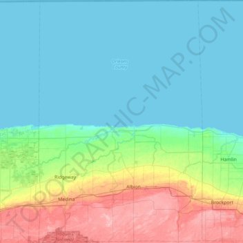
Name: Orleans County topographic map, elevation, terrain.
Location: Orleans County, New York, United States (43.12841 -78.46643 43.63475 -77.99518)
Average elevation: 351 ft
Minimum elevation: 240 ft
Maximum elevation: 748 ft
New York trails, hiking, mountain biking, running and outdoor activities
Other topographic maps
Click on a map to view its topography, its elevation and its terrain.
Watertown
United States > New York > Jefferson County
Watertown is around 60 miles (97 kilometers) northwest of Syracuse, 20 miles (32 kilometers) south of the Thousand Islands and 328 miles (530 kilometers) northwest of New York City. According to the United States Census Bureau, the city has a total area of 9.3 square miles (24 km2), of which 9.0 square miles…
Average elevation: 643 ft
Saratoga Springs
United States > New York > Saratoga County > Saratoga Springs
Average elevation: 528 ft
Sojourner Truth State Park
United States > New York > Ulster County > City of Kingston > East Kingston
Average elevation: 125 ft
West Point
United States > New York > Suffolk County > Hampton Bays > Town of Southampton > Rampasture
Average elevation: 10 ft
East Hampton
United States > New York > Suffolk County > East Hampton > Village of East Hampton
Average elevation: 39 ft
Port Jefferson
United States > New York > Suffolk County > Port Jefferson > Port Jefferson
It wasn't until 1836 that the local leadership truly initiated the community's transition from a swampish hamlet to a bustling port town. Twenty-two acres of the harborfront, which flooded with the tides, were brought to a stable elevation with the construction of a causeway. Concurrently, the village was…
Average elevation: 85 ft
Frost Valley
United States > New York > Ulster County > Town of Denning > Frost Valley
Average elevation: 2,411 ft
Stormville
United States > New York > Dutchess County > Town of East Fishkill
Average elevation: 367 ft
East Taghkanic
United States > New York > Columbia County > Town of Taghkanic
Average elevation: 656 ft
Gloversville
United States > New York > Gloversville
The city sits in the foothills of the Adirondack Mountains and therefore is within a climatic transition zone. Gloversville experiences the warmer summer temperatures common throughout the Capital Region's Hudson and Mohawk Valleys while experiencing generally more copious precipitation throughout the year…
Average elevation: 902 ft
Oneonta
United States > New York > Otsego County > City of Oneonta > Oneonta
Average elevation: 1,467 ft
Lake Mohansic
United States > New York > Westchester County > Town of Yorktown
Average elevation: 522 ft
Lower Corners
United States > New York > Schenectady County > Town of Glenville
Average elevation: 673 ft
Van Buren Point
United States > New York > Chautauqua County > Town of Portland
Average elevation: 581 ft
Irving
United States > New York > Chautauqua County
Irving is a hamlet in Chautauqua County, New York, United States. (It also falls in Cattaraugus County and Erie County. The Cattaraugus County part of Irving is part of the Seneca Nation Native American territory, the Erie County part borders Brant, New York and also is part of the Seneca Nation territory. )…
Average elevation: 607 ft
Findley Lake
United States > New York > Chautauqua County
Findley Lake is part of the town of Mina in southwestern Chautauqua County, New York, United States. Situated at an elevation of 1440 ft (439 m) above sea level, this hamlet is located on the north shore of Findley Lake.
Average elevation: 1,519 ft
Leonardsville
United States > New York > Madison County > Town of Brookfield
Average elevation: 1,345 ft
Murray Isle
United States > New York > Jefferson County > Town of Clayton > Grenell
Average elevation: 256 ft
Dewittville
United States > New York > Chautauqua County > Town of Chautauqua
Average elevation: 1,394 ft
Woods Mills
United States > New York > Clinton County > Town of Schuyler Falls
Average elevation: 692 ft
Owasco Lake Station
United States > New York > Cayuga County > Town of Fleming
Average elevation: 827 ft
Terpening Corners
United States > New York > Tompkins County > South Lansing
Average elevation: 945 ft
Toll Gate Corners
United States > New York > Cayuga County > Town of Moravia
Average elevation: 1,073 ft
Globe Hotel Corners
United States > New York > Cayuga County > Town of Niles
Average elevation: 1,407 ft
Vernon Park
United States > New York > Westchester County > City of Mount Vernon
Average elevation: 102 ft