
Mannheim topographic map
Click on the map to display elevation.
About this map
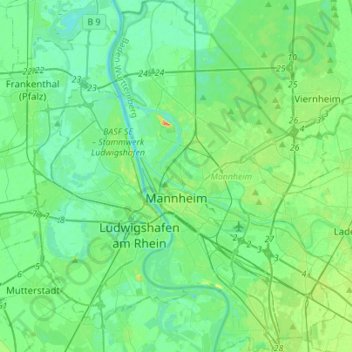
Name: Mannheim topographic map, elevation, terrain.
Location: Mannheim, Baden-Württemberg, Germany (49.41034 8.41416 49.59047 8.58999)
Average elevation: 318 ft
Minimum elevation: 276 ft
Maximum elevation: 459 ft
Other topographic maps
Click on a map to view its topography, its elevation and its terrain.
Stuttgart
Germany > Baden-Württemberg > Stuttgart
Stuttgart covers an area of 207.35 km2 (80 sq mi) and sits at elevation ranging from 207 m (679 ft) above sea level by the Neckar river to 549 m (1,801 ft) on Bernhartshöhe hill – something rather unique in large German cities. The most prominent elevated locales in Stuttgart are the Birkenkopf (511 m…
Average elevation: 1,158 ft
Andelshofen
Germany > Baden-Württemberg > Lake Constance district > Überlingen
Average elevation: 1,581 ft
Blauen
Germany > Baden-Württemberg > Landkreis Lörrach
In the 14th century, the mountain was recorded as the Blauwen or Blawen. Matthäus Merian's Topographia Sueviae in the mid-17th century calls it the Hoche Blawen ("High Blawen"). The parish boundary plan of the first Baden state survey of 1769/1770 distinguishes between the Hoch Blauen ("High Blauen") and the…
Average elevation: 2,877 ft
Affolter
Germany > Baden-Württemberg > Landkreis Calw > Nagold > Pfrondorf
Average elevation: 1,650 ft
Swabian Jura
The highest elevations reach just over 1,000 metres (3,300 ft). They are all in the southwestern part of the Jura, in the region of the Großer Heuberg.
Average elevation: 1,814 ft
Rembrechts
Germany > Baden-Württemberg > Landkreis Ravensburg > Wangen im Allgäu > Haslach
Average elevation: 1,811 ft
Kaiserstuhl
Germany > Baden-Württemberg > Landkreis Breisgau-Hochschwarzwald
Average elevation: 810 ft
Heidelberg Castle
Germany > Baden-Württemberg > Heidelberg > Königstuhl
All of these works are for the most part superficial and do not contain much information. In 1615, Merian's Topographia Palatinatus Rheni described Prince Elector Ludwig V as he "started building a new castle one hundred and more years ago". Most of the descriptions of the castle up until the 18th century are…
Average elevation: 919 ft
Hopfenweiler
Germany > Baden-Württemberg > Landkreis Ravensburg > Bad Waldsee
Average elevation: 2,028 ft
Sinsheim-Steinsfurt / Insenbach
Germany > Baden-Württemberg > Rhein-Neckar-Kreis > Sinsheim
Average elevation: 669 ft
Inneringen
Germany > Baden-Württemberg > Landkreis Sigmaringen > Hettingen
Average elevation: 2,579 ft
Nussdorf
Germany > Baden-Württemberg > Landkreis Ludwigsburg
The municipality (Gemeinde) of Eberdingen is located at the western extremity of the district of Ludwigsburg, in the German state of Baden-Württemberg, along its border with the districts of Böblingen and the Enz. Eberdingen is physically located in the basin of [de] the Neckar. Elevation above sea level in…
Average elevation: 1,053 ft
Zieflensberg
Germany > Baden-Württemberg > Landkreis Calw > Bad Herrenalb > Zieflensberg
Average elevation: 2,192 ft
Obergieß
Germany > Baden-Württemberg > Ortenaukreis > Hornberg > Niederwasser
Average elevation: 2,352 ft
Wolfenweiler
Germany > Baden-Württemberg > Landkreis Breisgau-Hochschwarzwald
Average elevation: 856 ft
Bad Rippoldsau
Germany > Baden-Württemberg > Landkreis Freudenstadt > Bad Rippoldsau-Schapbach
Average elevation: 2,349 ft
Kleinhegnach
Germany > Baden-Württemberg > Rems-Murr-Kreis > Waiblingen > Neustadt
Average elevation: 909 ft
Rielingshausen
Germany > Baden-Württemberg > Landkreis Ludwigsburg > Marbach am Neckar
Average elevation: 955 ft
Riet
Germany > Baden-Württemberg > Landkreis Ludwigsburg > Vaihingen an der Enz
Average elevation: 1,020 ft
Ableitung Erms
Germany > Baden-Württemberg > Landkreis Reutlingen > Dettingen an der Erms
Average elevation: 1,581 ft
Broggingen
Germany > Baden-Württemberg > Landkreis Emmendingen > Herbolzheim
Average elevation: 820 ft
Inselbad
Germany > Baden-Württemberg > Alb-Donau-Kreis > Munderkingen > Algershofen
Average elevation: 1,722 ft
Torfwerk
Germany > Baden-Württemberg > Landkreis Biberach > Bad Schussenried
Average elevation: 1,932 ft
Friedrichsturm
Germany > Baden-Württemberg > Landkreis Freudenstadt > Freudenstadt
Average elevation: 2,470 ft
Hohenhaslach
Germany > Baden-Württemberg > Landkreis Ludwigsburg > Sachsenheim
Average elevation: 922 ft
Hinterdenkental
Germany > Baden-Württemberg > Alb-Donau-Kreis > Westerstetten
Average elevation: 1,978 ft
Nordschwaben
Germany > Baden-Württemberg > Landkreis Lörrach > Rheinfelden (Baden)
Average elevation: 1,463 ft
Schnepfenstand
Germany > Baden-Württemberg > Landkreis Heidenheim > Herbrechtingen
Average elevation: 1,883 ft
Hohenzollern Castle
Germany > Baden-Württemberg > Zollernalbkreis > Bisingen
Average elevation: 2,073 ft
Escheck
Germany > Baden-Württemberg > Schwarzwald-Baar-Kreis > Furtwangen im Schwarzwald
Average elevation: 3,317 ft
Bleiche
Germany > Baden-Württemberg > Landkreis Konstanz > Stockach > Hindelwangen
Average elevation: 1,860 ft
Großherrischwand
Germany > Baden-Württemberg > Landkreis Waldshut > Herrischried
Average elevation: 3,018 ft
Kleinallmerspann
Germany > Baden-Württemberg > Landkreis Schwäbisch Hall > Kirchberg an der Jagst
Average elevation: 1,411 ft
Hauenstein
Germany > Baden-Württemberg > Landkreis Waldshut > Laufenburg (Baden) > Luttingen
Average elevation: 1,257 ft
Kapfenburg
Germany > Baden-Württemberg > Ostalbkreis > Lauchheim > Domäne Kapfenburg
Average elevation: 1,834 ft
Steinbronnen
Germany > Baden-Württemberg > Landkreis Sigmaringen > Bad Saulgau > Bierstetten
Average elevation: 2,093 ft
Urlau
Germany > Baden-Württemberg > Landkreis Ravensburg > Leutkirch im Allgäu > Urlau
Average elevation: 2,290 ft
Ground Zero
Germany > Baden-Württemberg > Landkreis Ludwigsburg > Ludwigsburg
Average elevation: 997 ft
Bad Teinach
Germany > Baden-Württemberg > Landkreis Calw
The township (Stadt) of Bad Teinach-Zavelstein is located at the center of the district of Calw, in Baden-Württemberg, one of the 16 States of the Federal Republic of Germany. Bad Teinach-Zavelstein's municipal area rests upon the plateau of the Enz and Nagold rivers, a landscape defined by severe river…
Average elevation: 1,827 ft
Tonbach
Germany > Baden-Württemberg > Landkreis Freudenstadt > Baiersbronn
Average elevation: 2,215 ft
Schnaitheim
Germany > Baden-Württemberg > Landkreis Heidenheim > Heidenheim an der Brenz
Average elevation: 1,808 ft
Lippisbacher Hof
Germany > Baden-Württemberg > Landkreis Lörrach > Obereggenen
Average elevation: 2,116 ft
Wilflingen
Germany > Baden-Württemberg > Ostalbkreis > Abtsgmünd
The main town of Abtsgmünd lies at the confluence of the Lein river into the Kocher (confluence elevation 367.4 m above sea level), predominantly on the left bank of the Kocher and left bank of the Lein. The furthest district of Untergröningen lies over 8 km west-northwest as the crow flies along two river…
Average elevation: 1,417 ft
Rheintal
Germany > Baden-Württemberg > Landkreis Breisgau-Hochschwarzwald > Müllheim im Markgräflerland
Average elevation: 1,391 ft
Apfelstetten
Germany > Baden-Württemberg > Landkreis Reutlingen > Münsingen
Average elevation: 2,477 ft
Obertüllingen
Germany > Baden-Württemberg > Landkreis Lörrach > Lörrach > Untertüllingen
Average elevation: 1,007 ft