
The Cobbles topographic map
Click on the map to display elevation.
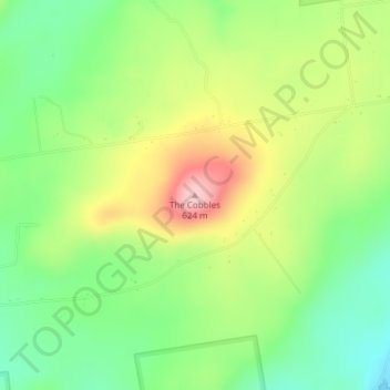
About this map
Name: The Cobbles topographic map, elevation, terrain.
Location: The Cobbles, Franklin County, New York, United States (44.43805 -74.00548 44.43815 -74.00538)
Average elevation: 1,709 ft
Minimum elevation: 1,470 ft
Maximum elevation: 2,044 ft
New York trails, hiking, mountain biking, running and outdoor activities
Other topographic maps
Click on a map to view its topography, its elevation and its terrain.
Salt Point
United States > New York > Dutchess County > Town of Pleasant Valley
Average elevation: 318 ft
Hawthorne
United States > New York > Westchester County > Town of Mount Pleasant
Average elevation: 374 ft
Catskill Park
New York's wilderness areas must be composed of 10,000 acres (4,000 ha; 40 km2) of contiguous land, twice the federal standard. Land is to be left as "untrammeled by man" and as close to its natural state as possible, offering outstanding opportunities for solitude. No artificially-powered devices are…
Average elevation: 1,644 ft
Village of Brightwaters
United States > New York > Suffolk County > Town of Islip
Average elevation: 26 ft
Mohonk Mountain House Property
United States > New York > Ulster County > Town of New Paltz
Average elevation: 748 ft
Erie Canal
United States > New York > Erie County > City of Tonawanda
The construction of the Erie Canal was a landmark civil engineering achievement in the early history of the United States. When built, the 363-mile (584 km) canal was the second-longest in the world (after the Grand Canal in China). Initially 40 feet (12 m) wide and 4 feet (1.2 m) deep, the canal was expanded…
Average elevation: 581 ft
Cayuga Lake
United States > New York > Cayuga County > Village of Union Springs
Average elevation: 866 ft
Genesee River
Only a small creek (Irondequoit Creek) flows in what is left of this large paleogeologic valley. The area of the lower river was also affected. Since the earth rebounded from the melting glaciers more rapidly in Canada than in New York, water from Lake Ontario was spilled over New York due to its lower…
Average elevation: 1,302 ft
Village of Florida
United States > New York > Orange County > Town of Warwick
Average elevation: 492 ft
Washington Heights
United States > New York > New York
Because of their abrupt, hilly topography, pedestrian navigation in Upper Manhattan is facilitated by many step streets. The longest of these in Washington Heights, at approximately 130 stairs and with an elevation gain of approximately 65 feet, connects Fort Washington Avenue and Overlook Terrace at 187th…
Average elevation: 82 ft
Great Sacandaga Lake
United States > New York > Fulton County > Town of Hadley
Average elevation: 1,214 ft
Manhattan Island
United States > New York > New York
Marble Hill is one example of how Manhattan's land has been considerably altered by human intervention. The borough has seen substantial land reclamation along its waterfronts since Dutch colonial times, and much of the natural variation in its topography has been evened out.
Average elevation: 56 ft
Chautauqua Lake
United States > New York > Chautauqua County > Bemus Point
Chautauqua Lake, at an elevation of 1,308 feet (399 m) above sea level, is higher than any of the Finger Lakes. It is also one of the highest navigable lakes in North America. The lake's water level is regulated by Warner Dam, with the water level lifted during the summer to allow for recreational boat use and…
Average elevation: 1,519 ft
New York, Westchester and Boston Railway
United States > New York > Westchester County > Village of Pelham > North Pelham
Average elevation: 92 ft
Town of Summit
United States > New York > Schoharie County
Summit is a town in Schoharie County, New York, United States. The population was 1,123 at the time of the 2000 census. The name is derived from a peak (Mt. Wharton) that was thought to be the highest elevation in the county.
Average elevation: 1,896 ft
Appalachian National Scenic Trail
United States > New York > Orange County > Village of Greenwood Lake
Plant life along the trail is varied. The trail passes through several different biomes from south to north, and the climate changes significantly, particularly dependent upon elevation. In the south, lowland forests consist mainly of second-growth; nearly the entire trail has been logged at one time or…
Average elevation: 899 ft
Village of Blasdell
United States > New York > Erie County > Town of Hamburg
Average elevation: 623 ft
Village of New Paltz
United States > New York > Ulster County > Town of New Paltz
Average elevation: 276 ft
Village of Valley Stream
United States > New York > Nassau County
At this time, the community did not have a post office, so residents had to pick up their mail in the village of Hempstead. After Pagan petitioned authorities for a post office, he was appointed postmaster and it was based in his farmhouse, now known as the Pagan-Fletcher House. He was advised that the…
Average elevation: 23 ft
Village of Elmira Heights
United States > New York > Chemung County > Town of Horseheads
Average elevation: 912 ft
Lake Mohansic
United States > New York > Westchester County > Town of Yorktown
Average elevation: 522 ft
Village of Cassadaga
United States > New York > Chautauqua County > Town of Stockton
Cassadaga is located on the northwestern edge of the Allegheny Plateau in western New York at 42°20'29" north, 79°18'56" west (42.341343, -79.315653) at an elevation of approximately 1,340 feet (410 m) above sea level. The village is located at the south end of Lower Cassadaga Lake, Lily Dale being located…
Average elevation: 1,371 ft
Charles E. Baker State Forest
United States > New York > Madison County > Town of Brookfield
Average elevation: 1,581 ft
Murray Isle
United States > New York > Jefferson County > Town of Clayton > Grenell
Average elevation: 256 ft