Geolocate

Margibi County topographic map

Click on the map to display elevation.

About this map
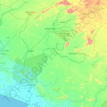
Name: Margibi County topographic map, elevation, terrain.

Location: Margibi County, Liberia (6.12457 -10.65187 6.90070 -9.84435)

Average elevation: 394 ft

Minimum elevation: 0 ft

Maximum elevation: 1,975 ft

Other topographic maps

Click on a map to view its topography, its elevation and its terrain.
Buchanan

Liberia > Grand Bassa County > Commonwealth-B

Average elevation: 10 ft

Grimes Farm

Liberia > Montserrado County > Todee

Average elevation: 259 ft

Dorkorta

Liberia > Gbarpolu County > Gounwolaila

Average elevation: 633 ft

Palala

Liberia > Bong County > Yeallequelleh

Average elevation: 768 ft

Harris Farm

Liberia > Lofa County > Salayea

Average elevation: 1,024 ft

Kpeloe Ndama

Liberia > Lofa County > Kolahun > Foya

Average elevation: 1,457 ft

Underwear

Liberia > Gbarpolu County > Bopolu

Average elevation: 302 ft

Noway

Liberia > Grand Bassa County > St. John River City

Average elevation: 266 ft

S.G. Kollie

Liberia > Bong County > Suakoko

Average elevation: 837 ft

Wahington Village

Liberia > Bong County > Jorquelleh

Average elevation: 758 ft

Zwedru

Liberia > Grand Gedeh County > Tchien > Zwedru

Average elevation: 702 ft

Dumagbe

Liberia > Grand Cape Mount County > Tewor

Average elevation: 62 ft

Gear up for your next adventure:

🥄Camping Utensil Set - Lightweight utensils for outdoor meals
🥘Titanium Cookware - Durable, featherlight pots and pans for backpacking
🔪Outdoor Multitools - Essential survival tools for gear repair and field use
🛰️Satellite Messengers - Emergency SOS and two-way messaging for off-grid adventures
📱Solar Portable Charger - Solar power bank for charging devices off‑grid

As an Amazon Associate, this site earns from qualifying purchases at no extra cost to you.