
Fort Meade topographic map
Click on the map to display elevation.
About this map
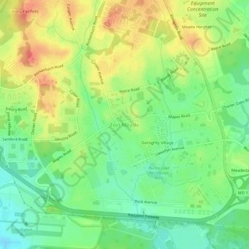
Name: Fort Meade topographic map, elevation, terrain.
Average elevation: 177 ft
Minimum elevation: 89 ft
Maximum elevation: 285 ft
Anne Arundel County trails, hiking, mountain biking, running and outdoor activities
Other topographic maps
Click on a map to view its topography, its elevation and its terrain.
Cape St. Claire
United States > Maryland > Anne Arundel County > Cape Saint Claire
Average elevation: 39 ft
Franklin Point State Park
United States > Maryland > Anne Arundel County > Columbia Beach
Average elevation: 3 ft
Forked Creek
United States > Maryland > Anne Arundel County > Arnold > Kimberly Woods Village
Average elevation: 72 ft
Magothy River
United States > Maryland > Anne Arundel County > Severna Park
Almost all of the creeks and tidal coves on the Magothy are named, partly as the result of a project started in 2001 by the Magothy River Association. They are shown on a map produced as part of that project, and the major ones are shown on the USGS topographic map.
Average elevation: 30 ft
Fort Smallwood Park
United States > Maryland > Anne Arundel County > Riviera Beach > Rockwood Beach
Average elevation: 7 ft
Magothy Greenway
United States > Maryland > Anne Arundel County > North Shore
Average elevation: 23 ft