
Oxbow Nature Preserve Lake topographic map
Interactive map
Click on the map to display elevation.
About this map
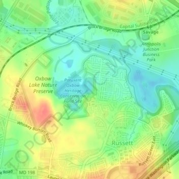
Name: Oxbow Nature Preserve Lake topographic map, elevation, terrain.
Average elevation: 180 ft
Minimum elevation: 105 ft
Maximum elevation: 279 ft
Other topographic maps
Click on a map to view its topography, its elevation and its terrain.
Annapolis
United States > Maryland > Anne Arundel County
Annapolis, Anne Arundel County, Maryland, United States
Average elevation: 26 ft
Arnold
United States > Maryland > Anne Arundel County
Arnold, Anne Arundel County, Maryland, 21012, United States
Average elevation: 49 ft
Monroe Gardens
United States > Maryland > Anne Arundel County > Glen Burnie
Monroe Gardens, Glen Burnie, Anne Arundel County, Maryland, 21061, United States
Average elevation: 72 ft
Yorktown
United States > Maryland > Anne Arundel County > Glen Burnie
Yorktown, Glen Burnie, Anne Arundel County, Maryland, 21108, United States
Average elevation: 98 ft
Pasadena
United States > Maryland > Anne Arundel County
Pasadena, Anne Arundel County, Maryland, 21122, United States
Average elevation: 52 ft
Bestgate Terrace
United States > Maryland > Anne Arundel County
Bestgate Terrace, Anne Arundel County, Maryland, 21405, United States
Average elevation: 72 ft
Queen Anne Hill
United States > Maryland > Anne Arundel County
Queen Anne Hill, Anne Arundel County, Maryland, 20779, United States
Average elevation: 43 ft
Crofton
United States > Maryland > Anne Arundel County
Crofton, Anne Arundel County, Maryland, 21114, United States
Average elevation: 115 ft
Annapolis Neck
United States > Maryland > Anne Arundel County
Annapolis Neck, Anne Arundel County, Maryland, 21403, United States
Average elevation: 23 ft
Villa Verdi
United States > Maryland > Anne Arundel County > Gambrills
Villa Verdi, Gambrills, Anne Arundel County, Maryland, 21108, United States
Average elevation: 128 ft
Herald Harbor
United States > Maryland > Anne Arundel County
Herald Harbor, Anne Arundel County, Maryland, 21032, United States
Average elevation: 33 ft
Glen Burnie
United States > Maryland > Anne Arundel County
Glen Burnie, Anne Arundel County, Maryland, 21061, United States
Average elevation: 121 ft
Riva
United States > Maryland > Anne Arundel County
Riva, Anne Arundel County, Maryland, 21041, United States
Average elevation: 36 ft
South Gate
United States > Maryland > Anne Arundel County > Shetland Square
South Gate, Shetland Square, Anne Arundel County, Maryland, 21108, United States
Average elevation: 82 ft
Magothy Forest
United States > Maryland > Anne Arundel County > Severna Park
Magothy Forest, Severna Park, Anne Arundel County, Maryland, 21146, United States
Average elevation: 43 ft
Fort Meade
United States > Maryland > Anne Arundel County
Fort Meade, Anne Arundel County, Maryland, 20755, United States
Average elevation: 177 ft
Franklin Point State Park
United States > Maryland > Anne Arundel County > Columbia Beach
Franklin Point State Park, Lincoln Road, Columbia Beach, Anne Arundel County, Maryland, 20764, United States
Average elevation: 3 ft
Galesville
United States > Maryland > Anne Arundel County
Galesville, Anne Arundel County, Maryland, 20765, United States
Average elevation: 13 ft
Crownsville
United States > Maryland > Anne Arundel County
Crownsville, Anne Arundel County, Maryland, 21140, United States
Average elevation: 108 ft
Gotts
United States > Maryland > Anne Arundel County > Crownsville
Gotts, Crownsville, Anne Arundel County, Maryland, 21032, United States
Average elevation: 112 ft
Mayo
United States > Maryland > Anne Arundel County
Mayo, Anne Arundel County, Maryland, 21037, United States
Average elevation: 7 ft
Glen Burnie
United States > Maryland > Anne Arundel County > Glen Burnie
Glen Burnie, Anne Arundel County, Maryland, United States
Average elevation: 79 ft
Riviera Beach
United States > Maryland > Anne Arundel County > Riviera Beach
Riviera Beach, Anne Arundel County, Maryland, United States
Average elevation: 20 ft
Fort Meade
United States > Maryland > Anne Arundel County > Fort Meade
Fort Meade, Anne Arundel County, Maryland, 20755, United States
Average elevation: 174 ft
Alloway
United States > Maryland > Anne Arundel County > Riviera Beach
Alloway, Riviera Beach, Anne Arundel County, Maryland, 21122, United States
Average elevation: 30 ft
Longmeadow North
United States > Maryland > Anne Arundel County > Severna Park
Longmeadow North, Severna Park, Anne Arundel County, Maryland, 21146, United States
Average elevation: 26 ft
Highland Beach
United States > Maryland > Anne Arundel County
Highland Beach, Anne Arundel County, Maryland, United States
Average elevation: 10 ft
Venice Beach
United States > Maryland > Anne Arundel County > Arundel on the Bay
Venice Beach, Arundel on the Bay, Anne Arundel County, Maryland, 21403, United States
Average elevation: 7 ft
Cape St. Claire
United States > Maryland > Anne Arundel County > Cape Saint Claire
Cape St. Claire, Cape Saint Claire, Anne Arundel County, Maryland, United States
Average elevation: 39 ft
Hardesty
United States > Maryland > Anne Arundel County
Hardesty, Anne Arundel County, Maryland, 20776, United States
Average elevation: 79 ft
Edgewater
United States > Maryland > Anne Arundel County > Annapolis > Edgewater
Edgewater, Annapolis, Edgewater, Anne Arundel County, Maryland, United States
Average elevation: 23 ft
Millersville
United States > Maryland > Anne Arundel County
Millersville, Anne Arundel County, Maryland, 21054, United States
Average elevation: 125 ft
Jessup
United States > Maryland > Anne Arundel County > Jessup
Jessup, Anne Arundel County, Maryland, 20794, United States
Average elevation: 213 ft
Odenton
United States > Maryland > Anne Arundel County
Odenton, Anne Arundel County, Maryland, 21112, United States
Average elevation: 161 ft
Garland Park
United States > Maryland > Anne Arundel County > Ferndale
Garland Park, Ferndale, Anne Arundel County, Maryland, 21062, United States
Average elevation: 121 ft
Mayo
United States > Maryland > Anne Arundel County > Mayo
Mayo, Anne Arundel County, Maryland, United States
Average elevation: 10 ft
The Woods
United States > Maryland > Anne Arundel County
The Woods, Anne Arundel County, Maryland, 21405, United States
Average elevation: 85 ft
Magothy River
United States > Maryland > Anne Arundel County > Severna Park
Magothy River, Severna Park, Anne Arundel County, Maryland, United States
Average elevation: 30 ft
Fort Smallwood Park
United States > Maryland > Anne Arundel County > Riviera Beach > Rockwood Beach
Fort Smallwood Park, Rockwood Beach, Riviera Beach, Anne Arundel County, Maryland, United States
Average elevation: 7 ft
Bluff Point
United States > Maryland > Anne Arundel County > Arden on the Severn
Bluff Point, Arden on the Severn, Anne Arundel County, Maryland, 21146, United States
Average elevation: 49 ft
Churchton
United States > Maryland > Anne Arundel County > Churchton
Churchton, Anne Arundel County, Maryland, 20733, United States
Average elevation: 7 ft
Severn
United States > Maryland > Anne Arundel County > Severn
Severn, Anne Arundel County, Maryland, United States
Average elevation: 154 ft
Linstead-on-the-Severn
United States > Maryland > Anne Arundel County > Severna Park
Linstead-on-the-Severn, Severna Park, Anne Arundel County, Maryland, 21146, United States
Average elevation: 36 ft
Magothy Greenway
United States > Maryland > Anne Arundel County > North Shore
Magothy Greenway, North Shore, Anne Arundel County, Maryland, United States
Average elevation: 23 ft
Admirals Walk
United States > Maryland > Anne Arundel County > Cape Saint Claire
Admirals Walk, Cape Saint Claire, Anne Arundel County, Maryland, 21409, United States
Average elevation: 39 ft
Annapolis
United States > Maryland > Anne Arundel County > Annapolis
Annapolis, Anne Arundel County, Maryland, 21411, United States
Average elevation: 43 ft
Willowdale
United States > Maryland > Anne Arundel County > Glen Burnie > Willowdale
Willowdale, Glen Burnie, Anne Arundel County, Maryland, 21061, United States
Average elevation: 75 ft
Gambrills
United States > Maryland > Anne Arundel County > Gambrills
Gambrills, Anne Arundel County, Maryland, United States
Average elevation: 121 ft
Dorrs Corner
United States > Maryland > Anne Arundel County > Dorrs Corner
Dorrs Corner, Anne Arundel County, Maryland, 21108, United States
Average elevation: 92 ft
Bay Ridge Junction
United States > Maryland > Anne Arundel County > Annapolis
Bay Ridge Junction, Market Quay, Annapolis, Anne Arundel County, Maryland, 21401, United States
Average elevation: 33 ft