
Make a donation
Gear up for your next adventure:
As an Amazon Associate, this site earns from qualifying purchases at no extra cost to you.
Schleswig-Holstein topographic map
Click on the map to display elevation.
Make a donation
Gear up for your next adventure:
As an Amazon Associate, this site earns from qualifying purchases at no extra cost to you.
Schleswig-Holstein
The Baltic Sea coast in the east of Schleswig-Holstein is marked by bays, fjords, and cliff lines. Rolling hills (the highest elevation is the Bungsberg at 168 metres or 551 feet) and many lakes are found, especially in the eastern part of Holstein called the Holstein Switzerland and the former Duchy of Lauenburg (Herzogtum Lauenburg). The longest river besides the Elbe is the Eider.
Make a donation
Gear up for your next adventure:
As an Amazon Associate, this site earns from qualifying purchases at no extra cost to you.
About this map
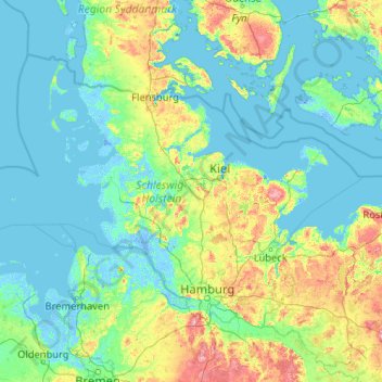
Name: Schleswig-Holstein topographic map, elevation, terrain.
Location: Schleswig-Holstein, Germany (53.35982 7.52116 55.09916 11.67239)
Average elevation: 56 ft
Minimum elevation: -20 ft
Maximum elevation: 525 ft
Make a donation
Gear up for your next adventure:
As an Amazon Associate, this site earns from qualifying purchases at no extra cost to you.
Other topographic maps
Click on a map to view its topography, its elevation and its terrain.
Berlin
Berlin straddles the banks of the River Spree, which flows into the River Havel (a tributary of the River Elbe) in the western borough of Spandau. Among the city's main topographical features are the many lakes in the western and southeastern boroughs formed by the Spree, Havel, and Dahme rivers (the largest…
Average elevation: 154 ft
Hopfensee-Achen
Germany > Bavaria > Landkreis Ostallgäu > Füssen > Hopfen am See
Average elevation: 2,654 ft
Wuppertal
Germany > North Rhine-Westphalia > Wuppertal
Uniquely for Germany, it is a "linear city", owing to the steep hillsides along the river Wupper. Its highest hill is the Lichtscheid, which is 351 metres above sea level. The dominant urban centres Elberfeld (historic commercial centre) and Barmen (more industrial) have formed a continuous urbanized area…
Average elevation: 686 ft
Make a donation
Gear up for your next adventure:
As an Amazon Associate, this site earns from qualifying purchases at no extra cost to you.
Hamburg
The neighborhoods of Neuenfelde, Cranz, Francop and Finkenwerder are part of the Altes Land (old land) region, the largest contiguous fruit-producing region in Central Europe. Neugraben-Fischbek has Hamburg's highest elevation, the Hasselbrack at 116.2 metres (381 ft) AMSL. Hamburg borders the states of…
Average elevation: 75 ft
Hamburg
The neighborhoods of Neuenfelde, Cranz, Francop and Finkenwerder are part of the Altes Land (old land) region, the largest contiguous fruit-producing region in Central Europe. Neugraben-Fischbek has Hamburg's highest elevation, the Hasselbrack at 116.2 metres (381 ft) AMSL. Hamburg borders the states of…
Average elevation: 184 ft
Make a donation
Gear up for your next adventure:
As an Amazon Associate, this site earns from qualifying purchases at no extra cost to you.
Obergieß
Germany > Baden-Württemberg > Ortenaukreis > Hornberg > Niederwasser
Average elevation: 2,352 ft
Potsdam
Germany > Brandenburg > Potsdam
The traditional towns in the governorate were small, however, in the course of the industrial labour migration some reached the rank of urban districts. The principal towns were Brandenburg upon Havel, Köpenick, Potsdam, Prenzlau, Spandau and Ruppin. Until 1875 Berlin also was a town within the governorate.…
Average elevation: 141 ft
Make a donation
Gear up for your next adventure:
As an Amazon Associate, this site earns from qualifying purchases at no extra cost to you.
Stuttgart
Germany > Baden-Württemberg > Stuttgart
Stuttgart covers an area of 207.35 km2 (80 sq mi) and sits at elevation ranging from 207 m (679 ft) above sea level by the Neckar river to 549 m (1,801 ft) on Bernhartshöhe hill – something rather unique in large German cities. The most prominent elevated locales in Stuttgart are the Birkenkopf (511 m…
Average elevation: 1,158 ft
Make a donation
Gear up for your next adventure:
As an Amazon Associate, this site earns from qualifying purchases at no extra cost to you.
Eifel
Germany > Rhineland-Palatinate > Landkreis Ahrweiler > Adenau
The Eifel is in the Atlantic climate zone with its relatively high precipitation; winters that are moderately cold and long with periods of snow; and summers that are often humid and cool. The prevailing wind is west/southwest. A relatively dry and milder climate prevails in the wind and rain shadow of the…
Average elevation: 1,919 ft
Bochum
Germany > North Rhine-Westphalia > Bochum
The city lies on the low rolling hills of Bochum land ridge (Bochumer Landrücken), part of the Ruhrhöhen (highest elevations) between the Ruhr and Emscher rivers at the border of the southern and northern Ruhr coal region. The highest point of the city is at Kemnader Straße (Kemnader Street) in Stiepel at…
Average elevation: 351 ft
Make a donation
Gear up for your next adventure:
As an Amazon Associate, this site earns from qualifying purchases at no extra cost to you.
Drosendorf an der Aufseß
Germany > Bavaria > Landkreis Bayreuth > Hollfeld
Average elevation: 1,460 ft
Teufelsberg
Teufelsberg was originally thought to be 115 metres (377 ft) high, which placed it at the same elevation as Großer Müggelberg (the summit of Müggelberge), and was the highest point in West Berlin. New measurements show that Teufelsberg is actually 120.1 metres (394 ft) high, making it higher than Großer…
Average elevation: 177 ft
Make a donation
Gear up for your next adventure:
As an Amazon Associate, this site earns from qualifying purchases at no extra cost to you.
Erlangen
In 1435 the church, which had been the daughter church of St. Martin in Forchheim up until this point, was elevated to its own parish. The main task of the Erlangen priest was the pastoral care in the city of Erlangen and the St. Martin's Chapel on the Martinsbühl, which was now named for the first time.…
Average elevation: 1,086 ft
Make a donation
Gear up for your next adventure:
As an Amazon Associate, this site earns from qualifying purchases at no extra cost to you.
Zugspitze
Germany > Bavaria > Landkreis Garmisch-Partenkirchen > Grainau
The mountain rises eleven kilometres southwest of Garmisch-Partenkirchen and just under six kilometres east of Ehrwald. The border between Germany and Austria runs over the west summit; thus the Zugspitze massif belongs to the German state of Bavaria and the Austrian state of Tyrol. The municipalities…
Average elevation: 7,546 ft
Monbijou
Germany > Rhineland-Palatinate > Südwestpfalz > Dietrichingen > Monbijou
Average elevation: 991 ft
Riedlhütte
Germany > Bavaria > Landkreis Freyung-Grafenau > Sankt Oswald-Riedlhütte
Average elevation: 2,444 ft
Obersalzberg
Germany > Bavaria > Landkreis Berchtesgadener Land > Berchtesgaden > Untersalzberg I
Average elevation: 3,061 ft
Make a donation
Gear up for your next adventure:
As an Amazon Associate, this site earns from qualifying purchases at no extra cost to you.
Hinterhausen
Germany > Rhineland-Palatinate > Landkreis Vulkaneifel > Gerolstein
Average elevation: 1,493 ft
Ludwigsburg
Germany > Schleswig-Holstein > Kreis Rendsburg-Eckernförde > Waabs
Average elevation: 56 ft
Make a donation
Gear up for your next adventure:
As an Amazon Associate, this site earns from qualifying purchases at no extra cost to you.
Rotthausen
Germany > North Rhine-Westphalia > Märkischer Kreis > Schalksmühle
Average elevation: 1,125 ft
Make a donation
Gear up for your next adventure:
As an Amazon Associate, this site earns from qualifying purchases at no extra cost to you.
Make a donation
Gear up for your next adventure:
As an Amazon Associate, this site earns from qualifying purchases at no extra cost to you.
Eifel
Germany > Rhineland-Palatinate > Landkreis Ahrweiler > Adenau
The Eifel is in the Atlantic climate zone with its relatively high precipitation; winters that are moderately cold and long with periods of snow; and summers that are often humid and cool. The prevailing wind is west/southwest. A relatively dry and milder climate prevails in the wind and rain shadow of the…
Average elevation: 1,919 ft
Make a donation
Gear up for your next adventure:
As an Amazon Associate, this site earns from qualifying purchases at no extra cost to you.
Neuschwanstein Castle
Germany > Bavaria > Landkreis Ostallgäu > Hohenschwangau
The municipality of Schwangau lies at an elevation of 800 m (2,620 ft) at the southwest border of the German state of Bavaria. Its surroundings are characterised by the transition between the Alpine foothills in the south (toward the nearby Austrian border) and a hilly landscape in the north that appears flat…
Average elevation: 3,222 ft
Make a donation
Gear up for your next adventure:
As an Amazon Associate, this site earns from qualifying purchases at no extra cost to you.
Erbel
Germany > Rhineland-Palatinate > Landkreis Altenkirchen (Westerwald) > Fluterschen
Average elevation: 922 ft
Make a donation
Gear up for your next adventure:
As an Amazon Associate, this site earns from qualifying purchases at no extra cost to you.
Make a donation
Gear up for your next adventure:
As an Amazon Associate, this site earns from qualifying purchases at no extra cost to you.
Bockstein
Germany > Saxony > Sächsische Schweiz-Osterzgebirge > Bad Schandau
Average elevation: 748 ft
Dessau
Germany > Saxony-Anhalt > Dessau-Roßlau
Dessau is situated on a floodplain where the Mulde flows into the Elbe. This causes yearly floods. The worst flood took place in the year 2002, when the Waldersee district was nearly completely flooded. The south of Dessau touches a well-wooded area called Mosigkauer Heide. The highest elevation is a 110 m…
Average elevation: 203 ft
Make a donation
Gear up for your next adventure:
As an Amazon Associate, this site earns from qualifying purchases at no extra cost to you.
Kleingladbach
Germany > North Rhine-Westphalia > Kreis Heinsberg > Hückelhoven
Average elevation: 276 ft
Make a donation
Gear up for your next adventure:
As an Amazon Associate, this site earns from qualifying purchases at no extra cost to you.
Liebenthal
Germany > Mecklenburg-Vorpommern > Vorpommern-Greifswald > Gützkow
Average elevation: 33 ft
Klettwitz
Germany > Brandenburg > Oberspreewald-Lausitz - Górne Błota-Łužyca
Average elevation: 430 ft
Make a donation
Gear up for your next adventure:
As an Amazon Associate, this site earns from qualifying purchases at no extra cost to you.
Heldberg
Germany > Rhineland-Palatinate > Landkreis Trier-Saarburg > Klüsserath
Average elevation: 705 ft
Make a donation
Gear up for your next adventure:
As an Amazon Associate, this site earns from qualifying purchases at no extra cost to you.
Zugspitze
Germany > Bavaria > Landkreis Garmisch-Partenkirchen > Grainau
The mountain rises eleven kilometres southwest of Garmisch-Partenkirchen and just under six kilometres east of Ehrwald. The border between Germany and Austria runs over the west summit; thus the Zugspitze massif belongs to the German state of Bavaria and the Austrian state of Tyrol. The municipalities…
Average elevation: 7,546 ft
Brocken
Germany > Saxony-Anhalt > Landkreis Harz > Wernigerode
The Brocken (German pronunciation: [ˈbʁɔkn̩] ), also sometimes referred to as the Blocksberg, is a 1,141 m (3,743 ft) mountain near Schierke in the German state of Saxony-Anhalt, between the rivers Weser and Elbe. The highest peak in the Harz mountain range, and in Northern Germany, it is subalpine, yet…
Average elevation: 3,159 ft
Make a donation
Gear up for your next adventure:
As an Amazon Associate, this site earns from qualifying purchases at no extra cost to you.
Wahnenbusch
Germany > North Rhine-Westphalia > Kreis Heinsberg > Erkelenz > Tenholt
Average elevation: 308 ft
Hohenzollern Castle
Germany > Baden-Württemberg > Zollernalbkreis > Bisingen
Average elevation: 2,073 ft
Bruck in der Oberpfalz
Germany > Bavaria > Landkreis Schwandorf > Bruck i.d.OPf.
Average elevation: 1,325 ft
Make a donation
Gear up for your next adventure:
As an Amazon Associate, this site earns from qualifying purchases at no extra cost to you.
Make a donation
Gear up for your next adventure:
As an Amazon Associate, this site earns from qualifying purchases at no extra cost to you.
Königshaus am Schachen
Germany > Bavaria > Landkreis Garmisch-Partenkirchen > Garmisch-Partenkirchen
The King's House on Schachen is located at Schachen, at an altitude with a view of the dramatic mountain backdrop of the Wetterstein Formation, about 10 km south of Garmisch-Partenkirchen, Bavaria. It can only be reached via a 10 km forest road, or a three-hour hike, ascending 1000m either from Schloss Elmau…
Average elevation: 5,344 ft
Neumühle
Germany > Bavaria > Landkreis Neustadt an der Waldnaab > Hammerles
Average elevation: 1,516 ft
Make a donation
Gear up for your next adventure:
As an Amazon Associate, this site earns from qualifying purchases at no extra cost to you.
Wingendorf
Germany > Rhineland-Palatinate > Landkreis Altenkirchen (Westerwald)
Average elevation: 935 ft
Ruine Falkenstein
Germany > Bavaria > Landkreis Ostallgäu > Pfronten > Benken
Originally known as Castrum Pfronten, the stone castle was built approximately 1270–1280 by Count Meinhard II of Tyrol on the borders of his land. Because of the unusual situation of the castle it has been interpreted in historical context as a symbol of opposition to the Duchy of Bavaria. (During the winter…
Average elevation: 3,084 ft
Make a donation
Gear up for your next adventure:
As an Amazon Associate, this site earns from qualifying purchases at no extra cost to you.
Reineberg
Germany > North Rhine-Westphalia > Kreis Minden-Lübbecke > Lübbecke
The Reineberg is a hill on the Wiehen ridge, south of the town of Lübbecke. With a height of 275.9 m above sea level it is, from a topographical point of view, not a particularly impressive eminence in this part of the Wiehen Hills, because, in the immediate vicinity are considerably higher summits, such as…
Average elevation: 594 ft
Gelstern
Germany > North Rhine-Westphalia > Märkischer Kreis > Schalksmühle > Heedfeld
Average elevation: 1,263 ft
Make a donation
Gear up for your next adventure:
As an Amazon Associate, this site earns from qualifying purchases at no extra cost to you.